Fatih
Fatih in History

This region that is at passageway from Asia to Europe has been home to diverse settlements from Paleolithic, Neolithic, and Bronze Age onwards. The first findings on history of the Historic Peninsula are from the Neolithic Age and are discovered at Yenikapı, during excavations for Marmaray. The Neolithic Age that corresponded to 6500 B.C. was when human beings started agricultural production, domesticated plants and animals. During this period, consciousness increased on writing, calendar, mathematics, construction and urbanization.
At excavations conducted at Sarayburnu, under Sultanahmet Square, findings dated to 5000-3000 B.C. were discovered. In the light of these findings it could be argued that the region has been inhabited for about 8500 years.
The first significant civilization at the Historic Peninsula were the Megarians that wanted to be a part of Mediterranean commercial network and benefit from trade of wheat. The Megarians settled in Sarayburnu area in 660-670 B.C. to establish a colony. It is known that before the Megarians this area was inhabited by the Thracians, Phrygians, and Bithynians. The Megarians enslaved resident people in line with the Spartan tradition and established Byzantion town. This town thrived on sea trade and its port was on the first bay on the turn to the Golden Horn from Sarayburnu, the Prosphorion Port.
Established about 100 years before Byzantion, Rome grew with conquests and became the most important power at the Mediterranean. The vibrant commercial network on the Mediterranean was the source of both political and economic power of the Roman Empire. As the Empire grew old, it started to lose its effect and strength. The Empire was divided into two in 395 A.D. as the Western Rome and the Eastern Rome. Western Roman Empire could not resist pressure from North and went out of existence in 476 A.D. leaving its place to the Eastern Roman Empire where commercial life continued in all its vibrancy, that is the Byzantium.
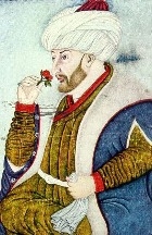
The Eastern Rome (Nea Roma), was alive for one thousand years more after the demolishing of the Western Europe. One of the most important reasons of this was the New Rome being a political capital while also a large port and a production center having strong walls surrounding the city. The walls protected the city from invasions for a long time. Also the fact that the Venetians and the Genoese was in control of the active commercial life in the region brought the end of Nea Roma. Although the city was the capital of the European civilization until the Latin Invasion in 1204, following the invasion it lost its former strength and surrendered to armies of Mehmed the Conqueror in 1453.
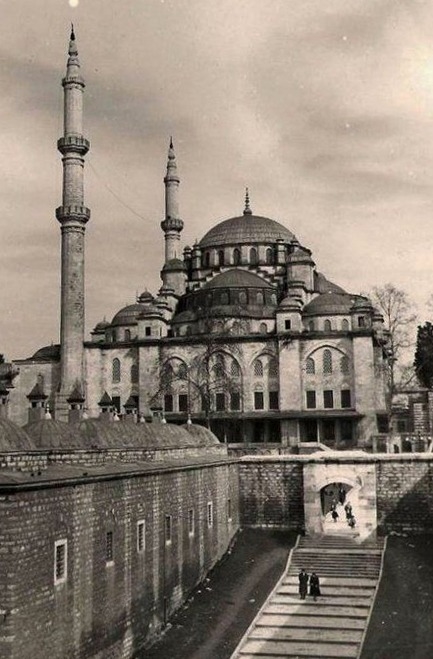
The new capital of the Ottomans, the Suriçi (Walled City) Historic Peninsula regained its former glory before the Latin Invasion in a short time. Mehmed the Conqueror took upon reconstruction activities right after the conquest. Initially, the city walls that were destructed during the conquest were repaired. The neglected and worn out Ayasofya was repaired and transformed into a mosque. In Fatih, construction began for the Mosque and Complex bearing the Sultan’s name was started together with the Topkapı Palace. Sahn-ı Seman madrasahs that were established in Fatih Complex being foundations of today’s Istanbul University were also opened in this period. Aqueducts that remained from the Byzantine period were repaired and the Grand Bazaar was constructed. Also in this period municipal organization of the city was also created. Mehmed the Conqueror assigned Hızır Çelebi as the Şehremini (mayor).
Also new residential areas were created to develop the city after the conquest. Muslim populations from the Anatolia and Rumelia were encouraged to migrate to the city. Christian and Jewish populations from various areas were also brought to the city and settled at certain areas. Only 50 years after the conquest, Istanbul with Historic Peninsula at its center became the biggest city of Europe, a center of science and arts.
The earthquake on September 14th, 1509 that cast its mark on the 16th Century and that is also known as the “Little Apocalypse” damaged the city to a great extent. The earthquake that lasted for 45 days caused great damage on thousands of buildings, there was not even one minaret that was left standing in the city. Many monuments at the Historic Peninsula that is the city center were either destroyed or damaged.
By Sultan Bayezid II (1510) the city was almost re-established with employment of 80,000 persons. The Historic Peninsula received its share from this recovery and several immortal monuments remained to this day from that period.
The 46 years of reign of Suleiman the Magnificent between 1520 and 1566 was a period of growth for the Empire’s capital Istanbul as well as the state. During this period several invaluable monuments were built in Istanbul many of which remained standing to this day. The city had a wealthy supply of water with new dams, aqueducts, waterways, and fountains. Istanbul was adorned with madrasahs, caravanserais, Turkish baths, gardens, and bridges, gaining the complete look of a capital city. Again in this period the Golden Horn Port became one of the busiest ports of the Mediterranean.
Monuments constructed during the reign of Suleiman the Magnificent especially those constructed by Mimar Sinan gave the city a brand new look. Süleymaniye Mosque and Complex, Şehzadebaşı Mosque and Complex, Sultan Selim Mosque and Complex, Mihrimah Sultan Mosque, Haseki Complex and Haseki Bath constructed for Hürrem Sultan were built in this period. Süleymaniye madrasahs made Istanbul a capital of education and science.
The reign of Suleiman the Magnificent witnessed some major catastrophes. The plague pandemic affected Istanbul frequently during this time. Fire in 1554 destroyed the area from Ayasofya to Tahtakale to a major extent. In 1554 strong wind led to rising level of sea waters and overflowing rivers, causing many people to drown. Flood as a result of heavy rain in 1563 caused even greater damage.
During the Tulip Age the city experienced many changes and innovations. Inspired from projects in Paris and Vienna, Grand Vizier Nevşehirli Damat İbrahim Pasha started housing projects in Istanbul. Initially the area around the Golden Horn was reclaimed and Golden Horn shores was made promenade areas. Many mansions and gardens were built at neighborhoods in and outside the Suriçi (Walled City). The neighborhoods that were destroyed in fires earlier were reconstructed.
The Tanzimat Period was started in November 3rd, 1839 when the reforms were read to the public at Gülhane Park of Topkapı Palace. During this period, westernization was accelerated and renovations were seen in Istanbul and the Historic Peninsula from architecture to lifestyle, education institutions to industrial organizations. During this time the city started to expand from the Suriçi (Walled City) to Bakırköy and in Galata towards Teşvikiye. Along the Bosporus the city grew towards Sarıyer and on the Anatolian side towards Bostancı and Beykoz.
During the Tanzimat Period, classical Ottoman architecture was abandoned and new structures were constructed in Westerns styles such as baroque, rococo, neogothic, and imperial. This change in style even penetrated into architecture of mosques.
This period also witnessed significant developments in infrastructure and urban services. Building a bridge on the Golden Horn, the tunnel (metro), Rumelia Railroad, opening of Şirket-i Hayriye that made local sea transport, establishing other municipal units of Şehremaneti (Municipality) organization, establishment of the first telegraph line, formation of Police Ministry and connected police stations, opening of Vakıf Gureba Hospital are among these developments.
The Tanzimat Period opened a new chapter in history of Istanbul. (August 31st, 1876). However, the Turco-Russian war that started a short time after (April 27th, 1877) caused panic in the city. Because of its proximity to the Rumelia front, Istanbul suffered many pains of the war. Dispatch of soldiers from the city to the West combined with patients and the wounded that came from front together with immigrants from Rumelia that escaped from the war caused many problems in the city. These immigrants tried to live in mosques and schools, in wooden and tin sheds in poverty.
In this period, the Historic Peninsula of Istanbul also experienced a major earthquake. Known among the public as “Three hundred and ten Earthquake” the 1894 earthquake caused severe damage to the Suriçi (Walled City). But, repair works started immediately.
Aksaray Quarter
It is surrounded by Cerrahpaşa Street to the north, Gazi Mustafa Kemalpaşa Street to the east, Kennedy Street to the south, Yokuş Çeşmesi and Davutpaşa İskelesi Streets to the west.
Early Age and the Byzantine Period
Aksaray is one of the oldest quarters of Fatih. During the excavations in Yenikapı for the Marmaray Station, along with many shipwrecks and historical artefacts, the 'Lost Harbour of Theodosius' and a grave and skeleton of the first inhabitants of Fatih dating back to 6500 BC were discovered.
The Aksaray settlement, which functioned as a natural harbour at the point where the famous Lycos Stream flowed into the sea during the Byzantium Period, remained within the walls of Constantine I when the city was transformed from Byzantium to Constantinople. Thanks to the alluvial soils carried by the Lycos Stream, the area around the stream close to the Marmara Sea (today's Yenikapı and Langa Street) was an orchard area, while the place where it flowed into the sea was a natural harbour. In the 4th century, a harbour named Eleutherios was built here. Long known as the lost harbour, this structure was unearthed during the Marmaray excavations.
This harbour, which was built by Theodosius, started to fill up as of the 7th century, both with what the Lykos Stream brought in and with the dumping of earthworks. By the 13th century, the harbour was completely out of use. In 1871, the construction of the railway line led to the disappearance of the harbour. In the 1950s, with the opening of the land road outside the city walls (Kennedy Street), the embankment was enlarged and the harbour was left far inland from the sea. Subsequently, Vatan Street was also opened and Lycos (Bayrampaşa) Stream was eliminated. Aksaray was also famous for its orchards along the coast. The water needs of the orchards were met from the water wells here. After the Byzantine period, orchards were also in use during the Ottoman period. At the entrance of Yenikapı Pier, the city's import and export gateway, there was a quarantine and a customs building. There were workplaces belonging to Armenian and Greek merchants.
The Mese Road, which was built as the capital of Eastern Rome during the reign of Constantine and was the main artery of the city, started from the Agora of Byzantium (where the Hagia Sophia is today), extended to the Tauri Forum (today's Beyazıt Square), and was divided into two when it reached the Capitol slightly to its west. One of its branches ran northwards parallel to the Golden Horn to the Poliyandri (Edirne) Gate, and the other branch reached today's Aksaray Square (today's Bovis Forum - Ox Square). From there, it would reach the seventh hill to the Arkadius Forum (Cerrahpaşa), and from there to the Porta Aura (Golden Gate) Yedikule Gate.
Aksaray was located on this most important axis of the imperial city. It was at the centre of both land and sea transportation and trade. It constituted the zone IX of the Byzantine city administration plan.
The Forum Bovis was built in the 380s and was in the form of an open market. Named after the statue of a bovine, the statue that characterised the square was used for executions. After the criminals were placed inside this statue, a fire was lit underneath it and the punishment was carried out. This method of punishment was first used in Sicily by Falaris, the Greek Despot of Sicily, and for the first time in Aksaray by burning the first Christians of İstanbul during the reign of Lulianus (361-363). The statue was later attacked and shattered during the reign of Heraclius (610-641).
The corpse of Emperor Phocas, who was overthrown in 610, Stefanos and Theodatos, the two deputies of Justinian II, who were removed from power in a coup d'état in 695, and the icon-breakers of the 8th century, were executed in this square and in this statue of a bull under which a fire was lit. The square was later transformed into an area where emperors returning from victory were ceremoniously welcomed.
Aksaray during the Ottoman Period
Before and after the conquest, Bovis Forum lost its commercial characteristic to a great extent. When the Karamanids were defeated by the Ottoman Commander İshak Pasha, Turkish families from Konya - Aksaray were compulsorily brought and settled in the vicinity of Bovis Forum. In addition to these, families from Bursa, Tire, Çarşamba, Sinop, Samsun, Skopje and Yenişehir were brought from Bursa and settled in Aksaray. Thus, the social structure, function and name of this place underwent a change with the Conquest.
In addition, in order to revitalise the commercial life of the city, Jews and Armenians were brought and settled in various parts of the city. Aksaray was also positively affected by this intensification of foreign migration. With the revitalised social, cultural and commercial life, inns with economic and cultural characteristics emerged. Beyazıt-Aksaray axis was one of the axes where these inns were located. During the reign of the Sultan Mehmed the Conqueror, Aksaray District was divided into 12 masjids, which were built with the aim of Islamising this district, and 12 quarters named after them. These founding quarters were Alembey, Baklalı Kemaleddin, Çakırağa, Gureba Hüseyin, Kemal Paşa, Kızıl Minare, Kovacı Dede, Mesih Paşa, Molla Kestel, Murat Paşa, Oruç Gazi and Sinekli Masjid quarters. As can be seen from the area covered by these quarters, it was much larger than today's Aksaray Quarter. In those years, between 5000 and 6000 people lived in Aksaray and the total number of the quarters in İstanbul was 262. Hindular Tekkesi Quarter and Ekşi Karadut Quarter did not have masjids. Today, the locations of the Ekiciler Quarter, Kumankeş Ahmet Ağa, Cevher Ağa Schools and Virdinar Sebili are unknown. Armenians and Greeks lived on the coast and slopes of Aksaray and Turks lived in the inner parts. Despite its rich demography, the quarter did not have a cosmopolitan disorder. It was a quarter inhabited by bureaucrats, madrasa scholars and students, and Turkish spoken in this quarter was at the best of its time.
Old Aksaray was the area surrounded by Camcılar Mosque, Murat Pasha Mosque, Aksaray Police Station, Çakırağa Mosque, tram warehouse and Pertevniyal Mosque. In this area, there were public baths, lodges, coffee shops, and pudding and pastry shops. The most central part of this area was İslamder Pasha Muhteki Şekerciler Street.
The streets of Aksaray used to be narrow, and the houses forming these streets used to have bay windows, and there used to be flower pots, house cats and bird cages in the bay windows. There used to be gizzards where the doors with iron and brass ring-shaped knockers were opened. The entrance areas of the house used to be covered with Malta stone or earthen floor. Houses used to be decorated with handicrafts of skilful women and cleaned. Also red syrups, aged canton oils, rose vinegars, mint and peppermint juices, bitter trees, senna, sugar candies and tamarinds used to be kept in the medicine cabinets of the houses. In addition to these medicines, which were generally good against diseases, the "share given to the onlooker" was respected especially in the month of Muharram and Ashura was served. In the spring following the winter, spring festivities, especially the purple wisteria flower, which was a favourite of the people of Aksaray, were held. When May came, the gardens of the coffee houses would be prepared for their customers. In Aksaray, the coffeehouses frequented by the bureaucrats and the educated people and the coffeehouses frequented by the tough hoodlums were separate. There were also "Semai Coffeehouses" where minstrels and poets hung out. Before Şehzadebaşı Direklerarası, Aksaray's "Yeşil Tulumba Square" was the most entertaining place in İstanbul. That square was in the middle of the road descending from Laleli Mosque to Aksaray. There were famous places such as Giritli Necati Efendi, Dilgüşa Coffee Houses, Yeşil Tulumba and Çavuş's Coffee House. These places used to be so crowded that there would be no seats left. Among many other coffeehouses in Aksaray, the famous one was Odabaşı Coffee House. This place was usually the hangout of famous people such as the writer Ahmet Rasim, the hoodlum Arap Hüsam, and Deli Nüzhet, father of Rıfat Pasha, one of the mayors of İstanbul. There were also hashish cafes in Tophane and Üsküdar, as well as in Aksaray. These places, which were not respected by the general public, were the hangout spots of wandering travellers, horse riders, so-called dervishes with their coins and cones, and prodigals in cardigans and furs.
Semai coffeehouses tended to be more ornate than others, with coloured paper and birdcages hanging from the ceilings. In these places, minstrels used to have conversations with the accompaniment of musical instruments. For the last 200 years, Aksaray had been a district where middle and lower middle class families lived. The people of Aksaray were divided into two groups: artisans and officials. The artisans were unpretentious people living in 2-3 room houses. The high officials, who lived in three-storey, 12-room houses with two consoles in each room, with courtyards and gardens around Sinekli Bakkal and Murat Pasha Mosque, were generally state officials.
Those who went a bit too far in the coffeehouses, where political conversations and organisations were held before the Second Constitutional Monarchy, were sent into exile by the Ittihad and Terakki Government. Some of these names included Mevlanazade Rıfat and Ali Kemal, journalist Hasan Fehmi and Ahmet Samim. There was also a group in Aksaray, known as the 12's, who committed extortion, gambling, drinking and adultery and got on well with the security forces of the period. They used to stone houses, tease women and girls, and even kill people. There were many open and secret brothels, dens and prostitution houses on Şekerci Street and other places. Officials of all ranks, including high-ranking officials, were seen in these places. Apart from the entertainment activities of a certain group of people, there were also entertainment events organised with the participation of the people at Yeşil Tulumba Square. In one of these, "Hoy Goycular" would come at the beginning of Muharram. In groups of four or five, burly, blind, lame, crippled, with colourful turbans and cones on their heads, wearing quilted turbans, bags on their backs and dogs with them, they would knock on all the doors and they used to beg in a peculiar style: "I set out from Aksaray. We do not look left and right. Man on the ground and angel in the sky. Watermelon sometimes turns out to be unripe".
Ramadan and Eid al-Adha were usually celebrated by the people in Yeşil Tulumba Square. It was an indispensable place especially for children. Girls and boys dressed in various festive dresses would spend their allowances they received from their elders by buying the favourite snacks and drinks of the period such as rooster candy, chewing gum, hazelnuts, seeds, chickpeas, pistachios, Turkish delight, syrup, paste, and soda pop. Furthermore, Ramadan was a month of entertainment in Aksaray as it was in the Direklerarası in Şehzadebaşı. From evening until dawn, people would have fun with performances such as Karagöz and Hacivat, visit dervish lodges and shrines during the day, and in the evenings, rich families would go for a walk on Aksaray-Divan Yolu Street, where various dessert, beverage and tea shops were located. Meanwhile, non-Muslim restaurant owners would not open their restaurants out of respect. Those who were already fasting would give up work for a month. Even civil servants would take their work slowly.
The New Military Barracks in Aksaray
When Suleiman the Magnificent wanted to build a large mosque in Şehzadebaşı for his son Şehzade Mehmet, who died at a young age, he had the janissary barracks (old chamber), which had been stationed in this place by the Sultan Mehmed the Conqueror after the Conquest, transferred by building a large barracks called Yeni Odalar (New Chambers) with a square called "Meat Square" in the middle, close to Vatan Street in today's İskenderpaşa Quarter. "Meat Square" is famous for its "mutinies" which became symbolic in the Janissary revolts. In 1826, when the Janissaries in the New Chambers rebelled against the discipline of the Eşkinci Ocağı (the New Military Unit), which was established with the aim of creating an alternative army to the deteriorating Janissaries, Sultan Mahmut II issued the edict of the incident known in our history as "Vak'a-i Hayriye" (The Auspicious Incident) and abolished the Janissaries by executing approximately 10,000 rebels. Keçecizade İzzet Molla described this event in a poem he wrote based on the abjad calculation as follows: "Blaspheming many blessings, they piled them up in the Meat Square, the cauldron was overturned, and the guild was destroyed."
There were seven gates of the New Chambers Barracks, and since one of these gates was the entrance for the meat of the barracks, the square where this gate opened was called the Meat Square. This square was also the training (drill hall) square. Around this square, there was a gunpowder and candle making factory, 8 butcher shops and a masjid. The kaputluk (janissary dress) and the room of the Janissary Agha were also located in this square. The meat of the Janissaries was prepared in the slaughterhouses outside the walls of Yedikule and transported to this place every morning by 30 horses.
The place of this guild, which turned into ruins, was opened for settlement in 1933. Today, only the Meat Square Cistern next to the Ahmediye Mosque remains from this historical building group.
Important Historical Events of Aksaray
The most important historical events of Aksaray after Vak'a-i Hayriye were the fires. Due to the wooden building stock, inadequate pump organisation and lack of water, Aksaray was burnt to ashes numerous times. These disasters were prevented in the Tanzimat Reform Period by transforming into a masonry building and modern fire brigade system.
Fires that Affected Aksaray:
The first known fire was in 562, during the Byzantine Period.
- 1540 Old Aksaray Fire
- The Great Fire of 1660
- 1699 Şehremini Fire (With 310 scales of gunpowder burnt, 425 buildings and Aksaray Mosque were damaged.)
- 1716 3rd Cibali Fire (Laleli Aksaray line, Davutpaşa Mosque and many palaces and buildings were burnt down).
- 1757 6th Cibali Fire (The fire spread to Aksaray and burnt down many houses together with the New Chambers Barracks.)
- The Fire of 1855 (748 buildings burnt down in and around Yeşiltulumba Square on the Aksaray-Laleli route).
- In 1863, 186 buildings were burnt down on the same route.
- 450 buildings burnt down in the Langa-Aksaray, Koska-Laleli fires of 1908.
- 2400 buildings were burnt down in the great Aksaray fire on 23 July 1911.
A poet had expressed this disaster as follows:
"The capital was burnt, again, ah, it was devastated, and it burnt down with such a terrifying fire. It spread everywhere as if it was an ocean, and even people who did not know how to cry started to weep."
Yet another poet wrote the following about one of the fires:
"Many people were burnt with their property and their lives. It was not known whether the dead were men or women." Apart from the fires, Aksaray was also in trouble with the flooding of Aksaray by the Lycos (Bayrampaşa) Stream, which overflowed with the rains. The waters could cover the streets and avenues of Aksaray with a rain lasting two hours.
Former Social Areas of Aksaray
There used to be a market place opposite the Valide Sultan Mosque. After the shops here were sold to market vendors in the 1920s, this market place was demolished and converted into residences and workplaces. Again in Aksaray, there was a famous garden called Sütçü Bostanı. When the gardener who owned it died, his heirs did not engage in the same business, and in 1938 the İstanbul Municipality turned it into a park.
Commercial Life in Aksaray
Along with its commercial density, Aksaray was a centre where the houses of tradesmen who worked in other districts were located. Aksaray tradesmen consisted of coffee makers, sweet makers, goldsmiths, soap makers, halva vendors and tavern keepers. In this period, another tradesman who was doing the same job could not come and open a shop next to a tradesman practising the same profession. The law would not allow this. Vangel, the famous tripe seller of Aksaray, opened a shop on İnkılap Street in 1890 and operated it until 2002. One of the first pharmacies of İstanbul was opened in Aksaray in 1895 by Ethem Pertev Bey. Again in these years, along with the first fez shop, tradesmen such as dessert makers, pastry makers, soup makers, restaurant owners, bakers and snack sellers operated in these neighbourhoods. The Turkish bath, which became famous as "Saraylılar Hamamı", was also located there.
Local Services in Aksaray (From Past to Present)
İstanbul tradesmen began to be governed by the guild system after the Conquest. However, in the 17th century, the city was divided into 15 districts (municipal departments) along with the police services. Aksaray was one of these districts. In 1868, a department was established to manage Aksaray district locally. During the reign of Mahmut II, the construction of masonry buildings was started, and in 1869, electricity was provided to the district for the first time by making use of the Yedikule Gas House. In the same year, a tramway was established, and in 1909, transportation was started to be carried out by minibuses and buses. In 1913, the "public latrine" was put into service.
Drinking water networks were renewed, streets were started to be washed in 1914, and a ban on building wooden houses was put into practice in 1921. Aksaray Police Station was located at the junction of Millet Street and Cerrahpaşa Street. The police station mostly dealt with bullying, prostitution and theft offences. Aksaray underwent major physical changes during the Menderes Period. One of these is Yenikapı-Unkapanı Boulevard. The boulevard was built with a length of 1655 metres and a width of 50 metres at a cost of TRY 4.200.000 including the cost of expropriation. During Haşim İşcan's term as Mayor (1964-68), Haşim İşcan Passage, Millet and Vatan Avenues were constructed in the same years.
Sandıkburnu
It was an area built by filling method with the old Yalı Quarter on the north side and surrounded by the Marmara Sea on the south. This area was famous for its shabby houses and casino-like entertainment places. Since the 17th century, it was a place where the art of music was performed and alcohol was consumed the most.
It had colourful figures such as the composer-mevlithan, the Imam of the Holy House, the Emir of Surre, Hafız Mohlası with a beautiful turban and Enderunlu Hafız Hüsnü Efendi, who started drinking raki after the Isha prayer. After the Mosque of Edirne was taken back from the Bulgarians, he was a person who recited the adhan and mawlid in the mosque, expelled those who did not listen to the prayer and spoke during the fasıls he organised, and was fluent in Arabic and French. He passed away in 1919. In 1935, the most famous casinos were the Red Rose, Bizim and Ahmet's Havuzlu Bahçe Casinos in Sandıkburnu at the end of Mahramacı Street. The casinos disappeared with the opening of Kennedy Street.
Yalı Quarter
It was established as an Armenian Quarter. Surp Tateos Partogomeos Grogoryan Church, which is attributed to the two apostles of Jesus Christ, is still active even though it has a small congregation. The Kâtip Fountain, which bears the name of one of the streets of the quarter, is not in its present location. The disturbing life of Aksaray, which continued with its various vices and the famous 12's with their mayhem, faded after the 1960s. With the latest regulations, Aksaray Quarter was reconstructed under the name of Aksaray by integrating Yalı, Kürkçübaşı, Çakırağa and İnebey Quarters.
Akşemsettin Quarter
Akşemsettin Quarter, which has Fevzipaşa Street to the northeast, Vatanperver Street and Feyzullah Efendi Street to the southeast, Vatan Street to the southwest, and Akşemsettin Street to the northwest, is one of our old residential areas formed by the merger of Hocaüveys and Hasan Halife Quarters.
Byzantine Period
Vatan Street, located in the southwest of Akşemsettin Quarter, used to be a stream bed known as the Lycos Stream. This stream used to flow into the sea at Yenikapı, where the Marmaray Station is located today, after entering the north-western walls of Theodosius II and passing through the Langa quarter. There was also a harbour where the Lycos Stream, which was later called Bayrampaşa Stream, flowed into the sea. This harbour was unearthed during the metro excavations. Bayrampaşa Stream had a short distance, but it could cause floods especially in rainy seasons when its water became abundant. The dam built by the İstanbulites of that period, who had water problems, along the Lycos Stream and in the Langa Quarter, probably for the water they needed, collapsed one day during heavy rains, and the flood waters of the dam filled the ships moored in the harbour and sank them. The shipwrecks found during the excavations for the Marmaray Station were filled with mud and had sunk as a result of such an event.
Ottoman Period
After Sultan Mehmed the Conqueror, this area was declared as a foundation land by Beyazıt II; Sultan Selim used to come here from time to time to rest as a promenade. This area, which Sultan Selim loved very much, started to be known as Yenibahçe after this date. In fact, when Sultan Selim ascended to the throne, he set up his tent here and accepted the allegiance of the state officials in this place. The Bayrampaşa Stream flowed openly, overflowed in winter and watered the orchards around it. There was a vault in front of the madrasah built by Süleyman the Magnificent on behalf of his father Sultan Selim and used as a health centre today. The stream would enter the vault from here. Over time, the proliferation of construction in the areas where the stream was fed decreased its water. This area was transformed into a street by Adnan Menderes between 1956 and 1957. This area was originally a green area where vegetables and fruits were grown since the time of the Megarans and where the people who were engaged in this business had one-storey or two-storey houses. Apart from a few wooden bridges over the stream, there was also a stone bridge built by Sinan the Architect. It had two small tributaries such as the Karagümrük stream flowing from the slopes of Hırka-i Şerif and joining the Bayrampaşa Stream from the vicinity of today's district governorship building and the Malta stream joining the Bayrampaşa Stream from the place where today's finance building is located. Some of the monuments that were removed during the creation of Vatan Street are as follows: Located adjacent to today's Migros Shopping Centre, the Simkeş Masjid, Taşkasap Masjid, Camcılar Masjid at the beginning of the road leading down to Aksaray, Yenibahçe Masjid, Ördek Kasap Masjid, Kara Mehmet Pasha Mosque, Murat Pasha Bath, Çakırağa Masjid and their cemeteries and fountains. The janissary barracks were also located in this district until 1826. When the barracks were removed, the Romani people started to settle along the stream. When Adnan Menderes turned this area into a street, the Romani people were transferred to Neslişah and Hatice Sultan quarters (1957).
Alemdar Quarter
It is surrounded by Bab-ı Ali and Ankara Streets to the northwest, Hükümet Konağı Street to the northeast, Divan Yolu Street to the southwest and Alemdar Street to the southeast. It was named after Alemdar Mustafa Pasha.
Alemdar Mustafa Pasha
Alemdar Mustafa Pasha was born in 1750 in Hotin as the son of a janissary named Hacı Hasan. He was enrolled in the 42nd Aga Company due to his aptitude for this profession. Since he carried the flag of his company, he was called "Alemdar" ("flag bearer"). Alemdar Mustafa Pasha is one of the important figures of our history who, while he was the Landed Proprietor of Ruse, travelled from Ruse to İstanbul with 10 thousand soldiers to restore Selim III to the throne after he was dethroned by the Kabakçı Mustafa rebellion that broke out in İstanbul in 1808. In the meantime, let's explain the concept of "Landed Proprietor". Landed Proprietor is the title given to the armed force formed from local forces loyal to the state in order to protect the effectiveness of the state authority, which had weakened in this region due to the Russian and Austrian wars in the Balkans towards the end of the 18th century, against both internal bandits and enemies on the border. Alemdar Mustafa Pasha was the commander of such a force. Pasha, who achieved great successes in the wars with the Russians and the rebellions in the Balkans during his period, stormed the Sublime Porte with 10,000 soldiers on 28 July 1808 in order to put the Reforms of the Nizam-ı Cedit (The New Order) back into effect and thus to depose Mustafa IV and restore Selim III to the throne. However, since Selim III was killed at that time, he declared Mahmut II, the son of his uncle, as Sultan in his place. He resided in the Sublime Porte and from there he directed and administered the public order in İstanbul. However, 3 months after this event, on 18 November 1808, as a result of the Janissary rebellion, Pasha's house in the Porte, whose basement was full of gunpowder and similar war materials, was raided. Pasha, who could not get any help from the palace, killed himself and 600 rebel janissaries by firing the explosives in the basement of his house at a moment when his house was being intensely harassed. His body, which was found by the rebels after the explosion, was dismembered and thrown into a well outside the Yedikule
Ali Kuşçu Quarter
Ali Kuşcu Quarter was formed by merging the old Kirmasti and Şeyhresmi Quarters. It is surrounded by Yavuz Selim Street to the north, Haliç Street and Tetimmeler Street to the east, Kıztaşı Street and Eski Mutaflar Street to the south, and Fevzipaşa Street to the west.Topographically, this area is one of the most important hills of Fatih. The location of Fatih Mosque is a flat area running from south to north along Daruşşafaka Street, except for Büyük Karaman Street. Only the west side of Fatih Street facing Fevzipaşa Street forms a slope. A large part of our quarter, taking half of Darüşşafaka Street, was located within the land walls built by Constantine I. Likewise, in the administrative structuring of the city during the Byzantine Period, it was within the boundaries of the 11th quarter. The famous Mese (Divanyolu) Road, which started in front of the Million Stone in Sultanahmet, had a branch extending from Beyazıt (in Philadelphion) to Aksaray and from there to Yedikule, and another branch passing through the courtyard of Fatih Mosque on the Fevzipaşa side and extending to Edirnekapı. A very important axis of land trade and transportation in the Byzantine and Ottoman Periods passed through the middle of the quarter. Considering that the land walls of the city (Byzantion) of that time passed through the place where the Haşim İşcan Passage is located today and descended from Yenikapı to Marmara, it is estimated that the part outside the city was a rural area.
Emperor Constantine I, who decided to make Byzantion Constantinople and drew and implemented the first plans, first designed the city with a capital architecture in accordance with the Pagan faith. However, in the face of the unstoppable spread of Christianity, he himself accepted Christianity unofficially towards the end of his life, either willingly or by necessity. As an expression of this, he built the famous Church of the Apostles (the first 12 holy people who believed in Jesus Christ) where the Fatih Mosque stands today. It is not known that there were any temples belonging to the Pagan Period before the Church of the Apostles.
Byzantine Period
The most important work built in our quarter during this period was the Church of the Apostles. The church was built according to the will of Constantine I after his death.
The intention was to build both the mausoleums of the Roman Emperors, who attached great importance to ostentation, and a temple of the Christian religion, which would be one of the most important religions of the future from its rapid progress, on this hill and to maintain respect for the mausoleums. It is estimated that the church, built in the centre of a large courtyard, was completed in 337. The courtyard was surrounded by colonnaded porticoes and buildings such as official buildings, baths and security units. The church was one of the most perfect temples of the period. The height of the cross-planned church, its bronze-covered roof and gilded interior decorations were legendary. This church was built in the style of a church mausoleum. It was designed with the representative tombs of the 12 Apostles and
Constantine's tomb in the centre. Constantine I wanted to get closer to Jesus Christ with this posthumous position and the rites he willed. Thus, he was spiritually honoured as the 13th Apostle. The Byzantine Emperors who came after him would be recognised by the Greek Orthodox Church as the 13th Apostle. However, since these ideas of Constantine I disturbed the leading Christian Orthodox, after his death, he was buried in the Church of Ayios Akakios for a while, not in his mausoleum, and then he was transferred to his mausoleum. After Constantine I, his son built another mausoleum in the same place and the emperors who came after him were buried in these mausoleums.
After the Apostle Constantine I, religious rites, especially on feasts such as Easter, the emperors used to leave the palace and participate in these celebrations with great ceremonies. The 2nd and 7th Councils convened in this church and took important historical decisions. The church, which was worn out over time, was restored by Emperor Justinian I in 550.
The Church of the Apostles has gained a very symbolic value due to the mausoleum of the founder of the city and the acceptance of Christianity by the Roman Empire. It was regularly maintained and decorated at regular intervals by subsequent emperors. However, the Latin invasion in 1204 was a disaster for the church. The administration of the church was given to the Latin clergy, the mausoleums were looted, and the relics (sacred objects) of the church were stolen and taken to Europe. In addition, the statue of the archangel Michael in front of the church was destroyed in an earthquake in 1328. After these events, the church could not be restored. (When Constantinople was conquered, the famous Church of the Apostles was in ruins).
There is a cistern built in the courtyard of the Church of the Apostles during the Byzantine Period, which can still be entered between the Black Sea Orta Kurşunlu and Baş Kurşunlu Madrasas. Inside the cistern, there are 43 upright pillars positioned at certain intervals. However, substances such as inward depressions, slime rubble and tree roots have made the actual dimensions of the cistern invisible. The date of construction of the cistern is unknown. In the Byzantine Period, a number of works were built around the Church of the Apostle and in various parts of our quarter, but they have not survived to the present day.
Atikali Quarter
It is surrounded by Hattat Rakım Street to the west, Karakol Street, Draman Çukuru Street to the northwest, Mehmet Ağa Hamam Street to the north, Mehmet Ağa Mosque Street, Manyasızade Street to the northeast, Yavuz Selim Street to the southeast and Fevzipaşa Street to the southwest.
History
The Atikali Quarter was located on the northern side of the land walls of Byzantion and the first Constantinople founded by Emperor Constantine I. Atikali is estimated to have been a slightly higher area than it is today, considering that the hills of the cities have been levelled over a long period of time. The height that starts around Fatih Mosque to the east continues northwards towards Edinekapı, albeit with a slight difference. Again, the elevation starting from the edge of the Golden Horn to the east ends at Atikali Quarter and descends to Fevzipaşa Street (Vatan Street-Lycos Stream) with the same slope. The quarter was also on
the eastern side of the famous Mese Road, which started from Augusteon (Sultanahmet) Square, and branched off from Vezneciler in a north-westerly direction towards Edirnekapı (Philadelphion). The beginning of this road is the Million Stone, which was then considered as the point zero of the world. This road, which is an important branch of land trade, started to gain importance as of the reign of Constantine I. The quarter, which was a rural area or orchard area outside the first city, was taken into the Walled City with the expansion of the land walls during the reign of Theodosius II. Our quarter was in the 11th district in the administrative plan of Constantinople during the Eastern Roman Period.
Eastern Roman and Byzantine Period
We are aware of the existence of an important monument built in the region during this period. The name of the monument was Soter Philanthropos, which means "Christ who loves mankind". Built by Eirene Dukaina, the wife of Alekisos I Komnenos (1081-1118), this men's monastery was located southeast of Karagümrük Çukurbostan (Aetius Cistern). It is known that this monastery was connected to a women's monastery in the same vicinity. The monastery, which has not survived to the present day, is known to be present at the time of the Conquest.
Ottoman Period
After the Conquest of İstanbul, as in every district, a great Islamisation and Turkification activity was initiated here as well. These activities were carried out on the one hand by settling the Muslim population, and on the other hand with works that would change the region both in cultural and religious terms. These works were Atik Ali Pasha (Zincirlikuyu) Mosque, Semiz Ali Pasha Madrasah, the famous Zincirli Well, Efdalzade Fountain and Madrasah, Keskin Dede Masjid and Cemetery, Old Ali Pasha and Zincirlikuyu Baths, Calligrapher Mustafa Rakım Efendi Tomb, Palace Agha Fountain, Şeyhülislam Esad Efendi Fountain, Çukur Madrasah adjacent to Nişanca Mosque and Semiz Ali Pasha Madrasah.
Republic Period
Four late 19th and early 20th century civil architecture buildings have survived to the present day. The other buildings are generally two or three storey houses, often with gardens, which were converted into apartment buildings during the reinforced concrete construction boom of the 1960s and 1970s. One of the four surviving civil architectural examples is a masonry building on the side of Fevzipaşa Street and is used as a shop, while the other is a wooden building and is used as a construction material warehouse. The masonry building on Fevzipaşa Street once belonged to Dr Faruk Serkut, one of the founders of the Democratic Party and a member of parliament. During the 1960 coup d'état, he was tried in Yassıada and acquitted. The building at the beginning of Kimyager Street was the property of Osman Nuri Engin, one of our famous intellectuals. This building is one of our first masonry apartment buildings. The ground floor of the masonry building next to Ahmet Rasim High School was used by Osman Nuri Engin as a library warehouse. Before 1959, when the extension works had not yet been carried out, the beginning of Kimyager Street on Fevzipaşa Avenue was an important stop. So much so that Taksim Square and this point were the two important
endpoints of the route. Those who got off the minibus at this point would go in the direction of Çarşamba - Draman.
Name of the Quarter
The quarter was named after Atik Ali Pasha. Atik Ali Pasha was a Bosnian child from Sarajevo and was recruited to the Chamber of White Eunuchs through the devshirme method. After the education he received here, when Şehzade Abdullah was appointed as the governor of Karaman, he went with the prince as a lala. When Prince Abdullah passed away, he was first appointed as the Commander of Gemendire and then as the Commander of Shkodër. In 1486, Atik Ali Pasha became vizier and was promoted to second vizier due to his successes in the Peloponnese Campaign (1501). In 1487, he was sent to Tarsus during the Ottoman-Mamluk War. He defeated the Mamluks while he was the commander of the army. Then he defeated Yavuz Sultan Selim, who tried to seize the throne by force, near Çorlu (1511).
When Mesih Pasha died in 1501, he became the Grand Vizier. Although he was dismissed two years later, he was reinstated in 1506 and since he gained the trust of Bayezid II, he carried out many state affairs on behalf of the sultan. He supported Ahmet in the struggle between the princes and marched on Shahkulu, who started to threaten the Ottoman Empire. Although he defeated him, he was caught by surprise and was martyred by Shahkulu's soldiers near Sivas-Kayseri Gökçay region (2 July 1511).
Atik Ali Pasha, who was a statesman and a good commander, was also an honest, capable, personable and philanthropic person. In this sense, he had many historical buildings constructed. For example, Zincirlikuyu or Atik Ali Pasha Mosque at the intersection of Fevzipaşa Street and Atikali Pasha Street, Kariye Mosque and Madrasah, which was converted from a monastery next to the Landlord's Palace, the complex with mosque, madrasah, school, library and other outbuildings in Çemberlitaş, a mosque in Edirne, an imaret in Bursa and primary schools in Mora are his known works. In addition, he highly valued science and art, frequently gathered those who were engaged in this field in his palace and offered them banquets.
Ayvansaray Quarter
It is surrounded by the land walls to the north and west, Kariye Mosque and Kariye Türbesi Streets and Draman Street to the south, Kesmekaya and Ayan Streets to the southeast, and the Golden Horn Coast to the east.
There are two opinions regarding the name Ayvansaray. Firstly, it is said to be derived from "Animal Palace" due to the feeding of exotic animals, especially elephants, in this neighbourhood where the Old Blaherna Palace was located; and secondly, it is said to be derived from "Eyvan Saray" due to the high 'iwan' buildings located in this area.
Ayvansaray Quarter was reconstituted with a decision taken by the İstanbul Metropolitan Municipality Assembly on 16 July 2008 by transforming the former quarters of Avcıbey, Kasım Gürani, Balat Karabaş, Molla Aşkı and Atik Mustafapaşa into a single quarter under the name of the former Ayvansaray Quarter. The names of the merged quarters were taken from the names of the benefactors who contributed to the formation of the quarters. For example, Avcıbey Quarter; the original name of Avcıbey comes from Avcı Mehmet Bey. He was the head hunter of the Sultan Mehmed the Conqueror. After the conquest, he built a masjid here to Islamise and Turkify the quarter. His quarter, which was named after him, was also formed around him. However, the masjid was demolished in the 1950s and was never rebuilt.
Balat Karabaş Quarter consists of the area extending east of Ayvansaray Avenue and Mürselpaşa Avenue to the Golden Horn. Since it was outside the city walls, it used to be called "External Balat". During the Byzantine Period, this area was outside the Golden Horn walls. It was the place where the sewage in this part of the city reached the sea. The Walled City, where sea transport was available and therefore the boatmen worked, was also like a free trade zone. Namely, the administration of this period did not levy taxes on commercial goods coming from various countries. Only rent was collected from the warehouses where the goods were stored. This was a district where the rich and the poor lived together in connection with the movement of goods arriving by sea. In general, there was no cleanliness and city order in this place where the riffraff lived. In this period, along with many foreigners engaged in trade, Jews, known by the name of Ohri, also lived here. There were three synagogues belonging to this community. After the conquest of Constantinople, Jews from Kasturia in Macedonia and then from Spain and Portugal between 1492 and 1497 settled here. Until the 17th century, they built synagogues named Neve Shalom, Messina and Montias. However, when these buildings burnt down in the fires in the 17th century, the Jewish community dispersed.
This area was generally unlit at night, poorly maintained and damp as it was close to the Golden Horn. Misery and filth were the most visible faces of this area. However, in the streets of Karabaş Quarter, which were far from the Golden Horn shore, there were well-kept two-storey houses around temples such as the Ahrida and Çana Synagogues, where there were wealthy merchants and modest tradesmen, boatmen, porters, and various vendors doing business on foot. Towards the end of the 19th century, Jews realised the importance of education and established schools and vocational training stalls for boys and girls. After 1908, Jewish men began to be conscripted into the army as required by law, and then aid associations for the wives of Jewish soldiers who died in the wars began to be established here. Jews in Balat Karabaş Quarter migrated to Galata in the 1920s due to better trade and prosperity. The mobilisation initiated during the World War II years and the negative impacts such as the wealth tax caused Jews to migrate to Palestine (New State of Israel). The vacant places were occupied by people from the Black Sea region and the Jews who remained in the minority moved to the vicinity of Şişli-Osmanbey. Karabaş Quarter was one of the places where maritime trade was the most intensive in İstanbul since it was a quarter along the Golden Horn. Vapur İskelesi Street and Odun İskelesi Street were the most important transport points along the area. In addition, the garbage and boat piers were also famous. As mentioned before, the open sewers that flowed openly and overflowed from time to time in these areas were converted into closed sewerage systems in 1890, and were transferred to the sea. The generally poor population was made up of peddlers, boatmen and fire-fighters. Although the houses were generally one-storeyed, there were also large two-storeyed houses rented by Jews, which became famous as Jewish houses.
The district had two famous coffeehouses named Zakeriyas and Perendeoğlu. Of these, the pious and rowdy Perendeoğlu Coffee House was mostly frequented by fire-fighters. There was a shortage of houses in this quarter due to poverty and population density. There was a Jewish slaughterhouse on Karabaş Salhane Street here. Sephardic Jews and Romaniyot Jews who started to live in Balat mingled with each other, and some of them learnt Greek and started to get along with the local Greeks. The "Pol Yalan Synagogue" belonging to the Romaniyot Jews, which is thought to have been built during the reign of Sultan Mehmed the Conqueror, and the "Gerush Synagogue" belonging to the Jews coming from Spain were burnt down in the Dubek fire in 1911, leaving only the foundations and were destroyed by expropriation. The previously established Alliance Schools were also burnt down in this fire. These buildings were not renovated and their students were sent to schools in Hasköy. In the past, there used to be Demir Hisar Street in the direction of Ayvansaray. A building with a high chimney and round windows was built on this street. During World War II, rumours spread about this building, which was transferred to the Meat and Fish Institution, that the Jews here would be incinerated. Therefore, the name of the building in this psychology was "Los Ornos De Balat" (Balat Bakeries). The Or-Ahayim Hospital, which was built during this period (1858), is still in operation. Jews would occasionally quarrel with the Greeks and Armenians living in the area. On the other hand, they got along relatively well with their Christian and Muslim neighbours. Christians used to give colourful Easter eggs to the Jews, and they used to offer "pesah" (doughless cookies) to the Muslims and Christians. The most valid professions in these areas were rabbis, butchers, street vendors, water carriers, milkmen, sellers of nuts and vegetables, egg sellers and fishermen, as well as Jewish fire-fighters, who were famous for their rowdy behaviour and fights, and who were also responsible for carrying the dead to the cemetery. Rabbis had the duty of preaching religious sermons, teaching Mahazke Torah and Ralmud Torah, reconciling quarrels, and protecting from the evil eye. Jewish taverns were also famous. In addition to drinking, there was live music. In addition, cards games and music were played in coffeehouses. The regulars of these places were hoodlums, fire-fighters and street vendors. According to 1948 data, there were 80 coffee houses and 20 taverns in Balat.
In the Republican Period, as the Jews evacuated these areas, they were replaced by people from various regions of our country, who were engaged in trade, along with the people from the Black Sea region (boatmen). In this process, 2 million square metres of the Golden Horn, which was originally 6 million square metres, was occupied. And 622 factories and hundreds of houses were built on the occupied area. Leather manufacturing, paddy, liquid oil cleaning agents and a number of workshops settled along the coast and started to pollute the Golden Horn with their production. There had been various attempts to clean the polluted Golden Horn since 1943 until Bedrettin Dalan became the Mayor of İstanbul Municipality, but no action was taken. For the first time during Bedrettin Dalan's term, the buildings on the edge of the Golden Horn were demolished and removed together with the Balat Karabaş Quarter in 1987. Afterwards, Mr Recep Tayyip Erdoğan, who became the Mayor of İstanbul Metropolitan Municipality, had the wastewater flowing into the Golden Horn pumped to the bottom of the Marmara Sea by means of collectors, and 5 million tonnes of sludge accumulated in the Golden Horn was pumped to the quarries on the Black Sea coast. Afterwards, by transferring water from the Black Sea, he restored the Golden Horn to marine life.
Roman and Byzantine Period
The most important place in this area is the Crooked Gate (Porta Kaligaria). Its history dates back to before the construction of the famous Theodosius Walls. Before the walls were built, this was a small settlement surrounded by walls. It consisted of a church in the middle, a public bath called Nympheior, a theatre, a lusarion (playground), a bridge and two large porticos (covered, with columns in front and on the sides and under open arches), two bakeries, five bread shops, eleven streets and avenues and one hundred and sixty-seven buildings, surrounded by walls facing the Golden Horn from the slope. To the south of the Crooked Gate, close to today's Landlord's Palace, there was a small palace used by the emperors at that time and a few settlements around it. The basis for the establishment of this district was the shoe factory of that day (Kaligaria - Sandal). This gave its name to both the gate of the district and the district itself. This area was later enclosed by combining the sea walls with the land walls (Theodosius Walls). While this small settlement was included in the land walls, the Kaligoria Gate was preserved. Outside the Landlord's Palace, which was built seven hundred years after the construction of the city walls, a ditch was built for protection purposes up to the starting point of the slope descending to the Golden Horn.
Going back to the Crooked Gate, the Ottomans called this gate "Crooked Gate" after the conquest because it was not located on a plane in terms of entry and exit to the city, but in a crooked way, while this gate was combined with the land walls or due to the effect of earthquakes that occurred later.
Many churches and palaces were built between the Crooked Gate and Ayvansaray. For example, the palaces named Anastatisos, Danubios, Okeanos built in this area were united under the name Blachernai Palace. Like the Ancient Rome, the New Rome (Neva Roma) was also governed by regions. In this respect, this place corresponded to the second part of the 14th region. In order to meet the needs of the animals and churches in the region, there was a major water problem in the higher parts of the region. After the construction of Landlord's Palace, the walls between Landlord's Palace and Ayvansaray, between Anemas Palace and Toklu İbrahim Dede Tomb were rebuilt and fortified.
Since the location and defence of the Crooked Gate was weak compared to the other gates of the city (its sloping and hard ground did not allow the digging of a trench), the Avars in 626 and the Latins in 1204 managed to enter the city through this gate. So much so that the Latins built a church named St. Nicolaus here as a token of gratitude for allowing the Latins to enter the city. After the looting and destruction activities of the Latins, there was a difference of understanding in art and religion in Byzantium. Art was relatively revived, and according to the changing religious and world view, the isolation of the monasteries was ended and they became more open to the society. Starting in 1261, this understanding continued with the restoration of churches and monasteries during and after the reign of Michael VIII Paleologos and the Emperors started to use the Blachernai Palace. To the south of the Crooked Gate is the Avcibey Quarter. What made this quarter important in the Byzantine Period was the Kariye Museum (Chora Church) and the Panagia Hançerlotissa Church. These were the highest and most spacious parts of the city. Since it was relatively secluded, it was favourable for religious buildings such as monasteries.
To the north of the Crooked Gate is the Ayvansaray Quarter with its former name. Ayvansaray was a district where courtiers and nobles lived during the Byzantine Period and it was the extension of the Blachernia Palace. The name Ayvansaray is derived from the fact that there were cellars in this district dating back to Byzantine times, and animals brought from hot countries were kept in these cellars during the Ottoman Period. According to a rumour, it is said that the people called this place "Animal Palace" because of this situation. According to another opinion, the people called it "Iwan Palace" because of the arched and high Byzantine Palace located in this area. Ayvansaray Quarter, located within the land walls on the shore of the Golden Horn, is one of the places where Byzantine and Ottoman cultural heritage are intertwined. After the Conquest, the quarter quickly acquired the identity of a Turkish quarter and was inhabited by workers, small tradesmen, seafarers and fishermen. The name of this area was known as "Blaharnia", derived from the "blehron" (wild mint) or "bleho" (fern) that grew abundantly in this area or from the "laherna" (acorn) that lived abundantly on the banks of the Golden Horn at that time. In 626, during the sieges of the Avars, the Theotokoston Blahernon (Blachernia) Church, where Mary's dress (Maphorion) was preserved at the end of the Golden Horn shores in Ayvansaray, which was outside the walls of Ureodosius II during the sieges of the Avars, was taken under protection by Emperor Heraclius in 626 by expanding the Golden Horn walls of Ayvansaray. Byzantine Emperors used to live in their palaces in the place called Sarayburnu until the 11th century. However, in this century, due to the Turkish danger in the east, especially after Emperor Alexios Komnenos ascended the throne in 1180, the great palace in the south of the Hippodrome was abandoned and they started to move to the palaces in the Ayvansaray Region. Since the state officials settled in this region together with the emperors, it turned into a region where nobles lived. As the emperors and statesmen stayed in the region, its defence became more important. On the west side of Ayvansaray, which was difficult to defend in terms of land and sea sides, a fortress tower (a reinforced tower built just outside the walls for the defence of the castle gates) was built by Leon V in 813 on the place where Toklu İbrahim Dede Tomb is located today. Today, Toklu İbrahim Dede's cemetery and masjid are located in this inner castle. In the last great earthquake of İstanbul, one of the towers of this inner fortress, which contained the tomb of the king's daughter, was destroyed. The name of this inner fortress in the Byzantine Period was 'Peterion'. Emperor Emanuel Komnenos (1143-1180) built the single-storey city walls starting from the edge of the Landlord's Palace towards the Golden Horn and extending to the Heraclius walls at the tip of Ayvansaray. From the point where these land and sea walls meet, a wall descending steeply towards the Golden Horn was built. This wall was demolished in 1868 and the connection between the castle and the coast was provided by the xyloporta (wooden gate).
From the western part of the wall extending from the end of the Ayvansaray city walls towards the Golden Horn (north direction), there was a quarter that grew towards Eyüp Sultan-Defterdar Quarter. As of the 12th century, what made the quarter important was the presence of a pier that allowed the emperors to reach the Blakhernia Palace. After this pier, the Blakhernia gate of the palace was accessed. Another feature of this quarter was the fact that Justianus II (527-565) had built a church in the name of the Virgin Mary and churches named Frisfos and Nicolas, and that this was the necropolis (cemetery) area of the period. As a matter of fact, two column capitals with very fine workmanship were found during the excavation of the foot of the III Golden Horn Bridge built here in 1972.
Again, the small vaulted, ceramic-covered, painted grave chambers in the Tokmaktepe Fatih Cemetery, which rises towards the south-east after the plain of the Golden Horn, tell us that these are cemeteries. The name of the region is Ya Vedûd (Loving, desiring the good of all creatures and bestowing it to them). It is rumoured that when İstanbul was besieged and conquered, a person whom Allah loved living in the Walled City devoted himself to worship in Hagia Sophia. This person was Sheikh Abdül-Vedûd from Bukhara. Allah did not allow the conquest of Constantinople for the sake of this person until the 50th day of the siege, the day of his death. Constantinople could be conquered only after Abdul-Wadûd died. When Sultan Mehmed the Conqueror visited Hagia Sophia after the conquest, he saw the luminous body of this holy person in the place called "sweating pillar". Knowing the sanctity of the person, the clergy wanted to wash the body immediately, and when the sound of the body being washed came from the direction of the "sweating pillar", the people there took the body to Ayvansaray Tokmaktepe by sea. And upon the sound of "Ya Vedûd" coming from a grave already dug there, the body of this holy person was buried there and henceforth the name of this quarter became "Ya Vedûd". This area between the walls of Ayvansaray and the Third Golden Horn Bridge was both a cemetery and a quarter. The cemetery extended to the foot of Tokmak Tepe. There was also a orchard fountain in this area. Until 1972, there were 2 masjids, 2 water scales, 1 primary school, 2 mills, 8 fountains, 2 piers, 2 water closets, 1 flour and bulgur mill, 2 dervish lodges, 1 tannery, 2 baths and 2 cemeteries in this quarter. As a result of the expropriations made for the construction of the Third Golden Horn Bridge, some of the monuments in this area were moved, some of them were abandoned, some of them were demolished and buried in the ground, and some of them are still there today. During the period from the Ottoman Empire to the Republic, "Ya Vedûd" was a charming coastal quarter with its streets consisting of two-storey houses next to the cypress trees rising from the cemetery.
Ottoman Period
Ayvansaray Region was a place where palaces and churches were densely located during the Byzantine Period. Especially the Landlord's Palace, being the highest hill of Walled İstanbul, was the place where the humidity was the lowest and the air was the cleanest. However, in the late Byzantine period, like almost every other part of the city, this place had fallen into disrepair. Despite this, it was one of the most densely populated places, especially by Orthodox Greeks. After the Conquest, similar to other districts, Islamisation and Turkification started in this district in terms of architecture and population. In this context, many fountains, schools, madrasas, masjids, mosques, lodges and civil architectural buildings were built in this region. In this process, some churches that had fallen into disuse and ruins were converted into masjids and mosques, while new ones were started to be built in some other places.
Ayvansaray Gate
It is at the westernmost part of the city walls in the direction of the Golden Horn. Some of the city wall gates are civilian and some are military. Ayvansaray Gate is a civilian gate and was built in times of war. This gate was located right at the foot of Ayvansaray Masjid. However, the exact location of the gate is not known today.
Ayvansaray Bridge
According to the notes of travellers and Byzantine sources, there was a wooden bridge between Hasköy and Ayvansaray.
Balaban Agha Quarter
It is the area surrounded by Fethibey Street on the west, Vidinli Tevfik Pasha, Vezneciler and Darülfünun Streets on the north, Beyazıt Mosque Square on the east, and Ordu Street on the south.
Name of the Quarter
The quarter was named after Balaban Agha, the Sekban chief of Sultan Mehmed the Conqueror, who participated in the conquest of İstanbul. Sekban was a military class in the Ottoman army serving along the borders. The Sekbanbaşı was the commander of this class. When Sultan Mehmed the Conqueror ascended to the throne, he abolished the Janissary Agha in order to punish the Janissaries who committed acts of disorder during the coronation ceremony and had this duty assigned to the Sekbanbaşı. Thus, the Janissary Agha remained under Sekbanbaşı until the reign of Sultan Selim I the Grim. Probably Sekbanbaşı Balaban Agha built the masjid, which is known by his name and gives its name to the quarter, during the period when he held these two positions together. Balaban Agha had the Balaban Agha Masjid built in the 1475s on today's Vidinli Tevfik Pasha Street by converting it from an old Byzantine monument into a mosque. The masjid was open for worship until 1911. The masjid burnt down in the great fire of that year, but a new one was not built in its place, and between 1920-30 it was gradually demolished and a road was built over it. During the excavations carried out by the American-Byzantine Institute in the 1930s, it was found that this monument was an oval building with a diameter of 10.60 metres and that there were 6 cells with a grave in each of them and that there was a dome standing on 6 legs at the top. While this Christian Tomb was converted into a mosque, it was understood that the graves in the crypt were kept intact. During this transformation phase, a half-moon shaped last congregation place was added to the building. Balaban Aga's grave was also removed together with the masjid.
Balat Quarter
It is the area surrounded by Sarayağası Street, Fethiye Street and Zülüflü Street to the west, Hacı İbrahim, Kalpakçı Çeşmesi, Tatlı Memba Streets and Ayan Street to the north, Vodina Street and Hızır Çavuş Köprübaşı Street to the north, Golden Horn and Fener İskele Yolu Street to the east, Soğuk Tulumba Street, Camcı Çeşme Slope to the southeast, Yavuz Selim Street to the south, Manyasizade Street and Mehmetağa Mosque Street to the southwest.
This area of Balat Quarter, which is located in the northeast of the Historic Peninsula, includes the Fatih Girls' Anatolian Imam Hatip High School, Aspar (Çarşamba Çukurbostan) Cistern, Yavuz Sultan Selim Mosque, its cemetery and Sultan Selim Girls' Vocational High School, and extends to the east of the Golden Horn with a sharp slope, while the northeast direction of Sultan Selim Girls' Vocational High School extends to Vodina Street with the same slope as Camcı Slope.
The eastern parts of Manyasizade and Fethiye Streets, together with Kiremit Street, descend to Vodina Street with a steep slope, and from there, it meets the Golden Horn with a relatively flat area. As can be understood, our quarter was established on the northeastern slope of the Historic Peninsula facing the Golden Horn. Although Balat Quarter was outside the walls built by Constantine I, it was later included within the walls built by Theodosius II. It was located in the 14th region in the city administration established in this period. In 2008, with the decision taken by Fatih Municipality Council, Hatip Muslihittin, Tevkii Cafer, Kâtip Muslihittin, Hızır Çavuş and Tahta Minare Quarters were merged under the name of Balat Quarter. When our city was called Byzantion, the Fener District of our quarter consisted of a rocky slope descending steeply to the Golden Horn. It was probably dominated by a vegetation according to the climate dominated by the transition from the Mediterranean to the Black Sea. While the Golden Horn was an extension of the sea rich in fish, especially bonito, agricultural activities and fishing were carried out on its relatively flat land.
Roman and Byzantine Period
The name of the lighthouse is rumoured to be derived from 'petrion' (rocky) because it is rocky (Petrion) or from 'Fener' because there is a lighthouse on the ledge extending into the Golden Horn. During the Byzantine Period, there was a castle here for defence purposes. The quarter formed around the castle (petrion) was called the Petrion Quarter. There was also an Ayia Eufemi Church in this quarter. With the sea walls starting from Ayvansaray, Fener District was annexed to Constantinople in 345. These walls were built at a short distance from the sea.
Fener District was an important pier of this district of the city in terms of maritime transportation. Emperors would disembark at Fener Pier to go to Blaknerai (Blaherna) Palace, and from there they would reach the palace by road. Since the hills of Constantinople had a very wide topography, the sea route was more convenient for transport. Because of this superiority in transport, Fener was popular. This superiority contributed to the development of the Fener District.
When the Eastern Roman Empire adopted Christianity as the official religion, all pagan temples in Constantinople were demolished and converted into churches. In fact, the stones that could be used in the church construction of the temples in the places under the rule of the Roman Empire, columns, column spaces, stones used for arches and many other processed materials were taken from different locations and transported to Constantinople. In addition to the temples, they built squares, avenues, baths, aqueducts (Valens) and cisterns to meet the water needs of the city.
In addition, the most exquisite examples of Byzantine civil architecture were constructed in these places. However, all these reconstruction efforts of Byzantium were subjected to a great looting and destruction with the Latin Invasion of 1204. This was partly caused by the inhabitants of Fener. Because when the Latins besieged Constantinople, the inhabitants of Fener, who had good commercial relations with the Venetians at the time, did not stand against the Latin attack and were rewarded for allowing the invasion in the form of rape, destruction and looting. After this event, the Byzantine Empire moved to Nicaea, and when the Byzantine Empire returned to recapture the city in 1261, Emperor Michael VIII set fire to the quarter near the Golden Horn where the Latins lived. The Byzantine Empire began to experience the most vulnerable period of its history. The financially weak state was unable to maintain the city as before, and those who left the city during the Latin Invasion never returned. The city became deserted from district to district due to neglect, and this situation lasted until the conquest of Constantinople (1453). During the conquest, some 70 ships were launched into the Golden Horn by land. Despite the efforts of the Byzantines, the navy could not be burned and on the morning of 6 April, the Turkish navy sailed inside the Topkapı Walls, while the navy in the Golden Horn under the command of Zağnos Pasha made a landing at Fener.
Ottoman Period
The conquest of Constantinople, which was praised by our Prophet (pbuh), was bestowed to Sultan Mehmed the Conqueror. On the morning of 6 April, while the land forces of the Ottoman Empire entered the city through the passages opened in Topkapı with the cannons that had not been cast in that size until then, the naval forces in 70 ships launched from the land entered Constantinople from the Fener Coast under the command of Zağanos Mehmet Pasha. Constantinople had not recovered after the Latin invasion and was in a poor, ruined, desolate and restless state. After the conquest, a rapid reconstruction activity was initiated and basic rights such as freedom of religion and belief, inviolability of property, right to work and a fair city administration was introduced for everyone regardless of race, language and religion. After the conquest, Hagia Sophia was converted into a mosque and after the first Friday prayers, Sultan Mehmed the Conqueror, who saw that the patriarch did not come to visit him, asked the Patriarchate why the patriarch did not come to him, and the Patriarchate learnt that the patriarch Anastasios II was alive, but he resigned because he did not wish Constantine XI to interfere in religious affairs. Thereupon, Mehmed the Conqueror brought Scholarius Gennadios, who was against the union with the Vatican, to İstanbul and elected Gennadios as patriarch by putting pressure on the Spiritual Assembly of the Orthodox Church. In addition, after this election, Sultan Mehmed the Conqueror invited the patriarch to dinner, authorised him with the title of 'Head of the Nation' in religious and sectarian affairs, and supported him by giving him the 'Patriarchal Scepter' (as the Byzantine Emperors had done) as a sign of these privileges. He then escorted him to the palace gate and saw him off to the patriarchate. All this was the same as the Byzantine Patriarchal ceremonies.
Sultan Mehmed the Conqueror also gave the Patriarch an "Emanname", which defined the legal status of the Orthodox community in accordance with Turkish Islamic Law. This edict included the following provisions; "Let no one dominate the Patriarch, let no one, no matter who he is, interfere with him, let him and the priests in his entourage be exempt from all kinds of public services for life. Their churches shall not be converted into mosques. Marriage, burial and other customs shall be carried out according to the Greek Church and customs as they were before." These rights were renewed by all sultans from this date onwards.
After this event, the rapid reconstruction of Constantinople was initiated. First of all, people were brought from Anatolia to revitalise the city. Some of them were settled around the Church of the Twelve Apostles. When the Muslim population of the city increased, the Patriarchate was relocated to the Pammakaristos Monastery (where the Fethiye Mosque stands today) near the Çarşamba District. After 131 years of administering the religious affairs of the Orthodox community from this place, it was moved first to the Wallachian Mansion in Fener, from there to the Church of Hagia Dimitri in Balat, and from there to the Monastery of Hagios Georgi (Hagios Georgios) in 1602. This area, called Fener Kapısı Quarter, was one of the quarters that did not have a mosque and included today's Abdi Subaşı, Tahta Minare and Tevkii Cafer quarters. In Ekrem Hakkı Ayverdi's words, this district was called "Semt-i Meş- hura Âlem". Greeks, Serbs and captives who left the city during the war after the conquest were allowed to settle in the Fener Region. Nevertheless, when the city could not reach the desired population density, the Christian Greek and Armenian communities in the newly conquered places (such as the people of science and knowledge in the Peloponnese) were settled in İstanbul in the form of exile with a fatwa edict. Sultan Mehmed the Conqueror thus became the Kayser-i Rum (Caesar of Rome). In other words, he also accepted the rulership of Rome. This meant that Sultan Mehmed the Conqueror was the Sultan of all the peoples living under Roman (Greek) sovereignty. Greeks lived in the area extending from the border of Cibali Quarter to the border of Küçükmustafapaşa Quarter along the coast and to Manyasizade and Fethiye Streets in the west. Their families were employed in both religious and bureaucratic positions, as well as in skilled professions such as bankers, sailors, merchants and goldsmiths. The architecture of the houses they lived in consisted of thick stone walls, small windows with large thick iron bars in front of them, bay windows standing on consoles and depictions of animals in front of them, arched doors disproportionate to the size of the building, unlike Turkish houses, which were generally made of wooden materials. The buildings had two or three storeys and were adjacent to each other. Bay windows would usually protrude from the second floors onto the street. Some of the families living in this area originated from the Byzantine aristocracy and they used to live in ostentatious mansions. They were quite wealthy. They were treated like kings by their servants, and they lived and consoled themselves with this respect that reflected the splendour of their past. When they came from the aristocracy of the Byzantine Empire, the Ottoman administration appointed them to the administration of the provinces of Moldava and Wallachia. The gunsmith's parsonage in Fener was one of the most central bazaars in İstanbul at that time. Kalafathane on the Golden Horn Coast and Mumhane near the Balat Gate were the most active bazaars of the district. In such places, they were small-scale tradesmen, merchants, craftsmen, sailors, fishermen, shoemakers, carpenters and journeymen. They used to run taverns and cabarets in partnership with Jews. The people of Fener attached importance to education and raised their children in important education centres of the time such as Italy. In this way, they would learn Turkish, Arabic and many European languages, which would enable them to advance in business life and take important positions in the state, such as translators for the Imperial Council and the Navy. When Italian lost its dominance as the lingua franca to French, the Greeks of Fener started to learn French. Those who could not go abroad were educated in local schools. These schools were the Greek Erbeh High School (Red School) and the Greek Girls' High School (Ioakimyon Girls' High School). Despite this, according to a study conducted by Charleswhite in 1844, the literacy rate of Greeks was not higher than that of Turks. Some of the Greek families who served the Ottoman Empire were the Gikas, Kalimakis, Garagras, Sutsus, Ipsilantis, Mozugis, Rallis, Hangerites and Rosettis. These were families who took part in the administration of Wallachia and Moldavia in the 18th and 19th centuries. The most important structure of Balat Quarter on the Golden Horn was the ferry pier. This pier was between Abdi Subaşı and Tahta Minare quarters. Those who disembarked from here travelled all the way to the patriarchate. This place was called Fener Road and the pier was called Fener Pier. There was a two-storey mansion above the ferry pier in the 19th and 20th centuries. This mansion was a flamboyant building above the waters of the Golden Horn and had a function as a mixture of a pub and a coffee house (casino). From time to time, the feet of the people living on the lower floor would get wet with the waters of the Golden Horn caused by the waves of the ferries passing through the Golden Horn. On the left side of the Fener Pier, there used to be a boat dock descended by three steps. Boatmen used to carry passengers to Kasımpaşa via this pier. Since it was on the edge of the Golden Horn, Fener was also a place of entertainment. Since the possibility of travelling far was very limited, those who wanted to come to the square where Silahtar, Kâğıthane and today's Fener Police Station were located used to travel by boat. Especially on summer nights, this place was ideal for cooling off and having fun under the moonlight. Opposite the Fener Police Station, there was a customs building on the right side of the 3x3 metre ferry pier. The first official fire brigade was established in a location called Kılburnu. This unit, which was established after the fire brigades, had fire extinguishing vehicles towed by horses. These vehicles were equipped with hand pumps, hoses, buckets, ladders and tools used in fire extinguishing.
Another feature of this quarter was its taverns. This culture, which did not exist in Muslim quarters, was available in the Christian quarter of Fener. There were four regular taverns named Sakiyas, Gümüş, Halkalı Kamburoğlu and Taşanaki. There were two more taverns named Sakızlı and Kafesli in the vicinity of Kiremit Street. However, as the demographic structure changed, none of these have survived to the present day. The casino next to the Fener Pier was also closed in 1943. One of the important businesses in the courtyard of the church was the production of baptismal oil. This oil is sacred because it is used in religious rituals. Therefore, its production was carried out in accordance with traditional methods and in strict adherence to these methods. This oil, which represented the spiritual and political power of the Patriarchate, was prepared in large cauldrons over a period of several days, day and night, using sacred objects (such as books, icons, prayer books, etc.) as fuel, and then carefully filled into bottles and sent to all the churches of the entire Orthodox sphere. This product, which was an important source of income for the Patriarchate, is the reason why many sacred objects of historical value have not survived to the present day (due to their incineration). The Patriarchate ceased to produce this baptismal oil with the foundation of the Republic.
The Patriarchate also has a story of a middle gate that has been closed since 1821: After the conquest of İstanbul, the Greeks, who had gained a strong legal support with the "Emanname" of Sultan Mehmed the Conqueror, soon became rich through trade. These rich people also had influence over the Orthodox clergy because of their financial aid to the Patriarch. Moreover, in the eyes of the Renaissance movement that began to rise in the West, these rich people were highly respected because they were the descendants of Ancient Greece. Having become rich through their trade with Europeans, the people of Fener enrolled their children in Western academies and universities in order to reach the same level of culture as the Westerners. The desire for a new Hellenism was alive in the hearts and minds of these people of Fener. However, this desire, which reminded idolatry (Elen), with the acceptance of Christianity by Eastern Rome, was not accepted by the Orthodox. However, the persistent efforts of the wealthy people of Fener yielded results and the name of the church was changed to the Greek Orthodox Church. With Greek Orthodoxy, efforts were being made to establish a new Roman Empire by Greekising other races. At that time, the Principalities of Wallachia and Moldavia accepted Ottoman rule in order to guarantee their autonomy. Since the churches of these Principalities were affiliated to the Orthodox Patriarchate in İstanbul, Hellenist merchants (rich people) bought land, opened academies and schools, and organised various conferences and seminars to spread Hellenic culture in these areas. The foundation of the Eastern Roman Empire began to be laid here. A Megalo Idea and organisation (Ethniki Eteria) was formed. The aim was to revive the Byzantine Empire under the leadership of the Greek Orthodox Patriarch of İstanbul. Patriarch Gregorios, many metropolitans and clergymen were involved in this endeavour. Finally, the efforts carried out in Rumelia and İstanbul bore fruit and on 12 February 1821, a rebellion was launched in Mera. However, Benderli Ali Pasha, the Grand Vizier of the time, who followed these events with strong intelligence, informed Sultan Mahmut II about the treachery of the Greek officials from Fener working in foreign affairs and the support of the British, French and Russian embassies to the rebellion. Patriarch Gregorios was then interrogated. When he confessed his guilt, he was executed on 22 April 1821 by hanging in the middle door of the Patriarchate with a treason label on his chest. Subsequently, the traitors who had participated in the same crime with him, the Greek Beys of Fener, were also hanged. The new Patriarch, who was elected after this, protested this event by locking this door. There is a painting of Patriarch Gregorios on the inner side of the door and Grand Vizier Benderli Ali Pasha Street on the outer side. The door, popularly known as the "Grudge Gate", has been closed for 200 years.
Beyazıt Quarter
It is the area surrounded by the borders of Şeker Ahmet Paşa Street and Tığcılar Street to the north, Çarşı Kapı and Kalpakçılar Streets to the south, Çarşıkapı Nur-u Osmaniye Street and Kürkçüler Çarşısı Street to the southeast, Çuhacı Hanı Street to the east, Çadırcılar Street to the west and Bakırcılar Street to the northwest.
Beyazıt District has been the 3rd most active hill of the Historical Peninsula in all periods of history from Byzantium to İstanbul. It is a square that has been active for about 2 thousand years. For about 800 years, from Byzantium to Roman times, the area extending from the old Thracian gate (one of the exit gates of the city at that time) to Laleli, Fatih and Süleymaniye, where the tomb of Mahmut II is located, was a 'necropolis' (cemetery). The largest forum of the city in the Byzantine Period and one of the palace squares of the city in the Ottoman Period were here.
Since then, it has been the historical, cultural and commercial square of the Walled City. It has hosted these activities throughout history. Beyazıt District was a sub-district of Eminönü district in the last periods of the Ottoman Empire. It was named after the complex built there by Sultan Bayezıt II. Since Theodosius I organised this square in the most comprehensive way during the Roman Period, it was called "Theodosius Forum" at that time. Theodosius I was the last emperor who officially converted Rome from Paganism to Christianity and ruled both Rome at the same time. After his great struggles against paganism, he divided the empire among his sons before he died in Milona. Ten months after his death, his body was brought to İstanbul and buried (395). Another name of the square was "Tauri". It means Tauros (bull). It was rumoured that a cattle market was held here at certain times. It is also thought that this name was used because there were bronze bull head statues on the triumphal arch built by Theodosius. According to another rumour, there was a large hollow bull statue made of bronze or copper in the square. After the criminals were put inside, they were executed with a fire lit from below. Thus, another name derived from these rumours was "Tauri Square".
Beyazit Square in the Ottoman Period
After the Conquest, Sultan Mehmed the Conqueror had a palace built on a large part of this square, which was later known as the Atik Palace. Thus, the empty part of the shrinking square turned into Sarayönü Square. Since the trees in this part of the square, which were in a densely spaced arrangement, allowed robbers to work easily, a large part of them were ordered by Sultan Mehmed the Conqueror to be cut down. In addition, Sultan Mehmed the Conqueror had his first coin mint built in the place known as the "Simkeşhane". Afterwards, his son Sultan Beyazıt II had the second complex of the city built in this place after the Conquest. The complex included a mosque, madrasah, almshouse, caravansary, school for boys, bathhouse and the tomb of the sultan. The area between the complex and the mint was one of the busiest places in the city. In addition, entertainments including juggling, animal taming, magician and conjuring shows were organised in this area and in time it turned into a public entertainment centre.
In 1580 Mimar Sinan built shops on the side of the mosque facing the road, and in the 17th century these were followed by single-storey wooden shops selling stationery. Subsequently, housing started to be built in the square and it was so densely built that it was only possible to carry wedding goods from the square for Fatma Sultan's wedding by demolishing the eaves of the houses. The square was again hit by fires and earthquakes during this period. In the 18th century, it turned into a market where sacrificial animals were sold and the south part was reserved for the activities of permanent butchers. In this century, important buildings such as the "Simkeşhane" (Mint), Hasan Pasha Inn, Ragıp Pasha Tomb, Laleli Complex with its school and library were built on both sides of Ordu Street descending from the square to Aksaray. In addition to these buildings, it is worth remembering the presence of many shops tailored to the needs. During the reign of Mahmut II, the Aga Gate, which became vacant after the abolition of the Janissaries Guild, was allocated to the Shaykh al-islam. The Old Palace was deemed appropriate as the command centre of the "Asakir-i Mansure-i Muhammediye" Army, which was formed to replace the Janissary Guild. The remaining parts of the palace were demolished and converted into the Seraskier's Office. The courtyard walls of the Beyazıt Mosque were demolished so that the soldiers could train comfortably. A Sultan's Mansion was built for Sultan Mahmut II so that he could observe military ceremonies under today's Çınaraltı. The building, which later became derelict due to neglect, was demolished by the municipality in 1930.
Beyazıt Square from the Tanzimat Reform Period to the Republic
After Mahmut II organised Atik Palace as the military headquarters, the building was demolished during the reign of Sultan Abdülaziz. In its place, the "Daire-i Umur-i Askeriye", which would fulfil the same function and only had a different name, was constructed. Its gate was built by the French architect Bourgeois in the Serazan style (the gate of today's university campus) (1866). In the same year, the garden wall on the Bakırcılar Street front was completed. The mansions of Ali and Fuat Pashas, important pashas of the Tanzimat Reform Period, were also located in this military area. Fuat Pasha's mansion was on the west side of this complex, which would later serve as the Ministry of War. The mansion was first allocated to the Ministry of Finance and then to the Faculty of Pharmacy of İstanbul University. In addition to the military and political assets added to the square, cultural exhibitions were opened in the mosque courtyard during Ramadan. These exhibitions, specially held for Ramadan, were a continuation of the Direklerarası. The first pharmacy of İstanbul was also opened opposite "Simkeşhane" (Mint) during this period. This pharmacy was like a clinic where two physicians, two of whom were operators, served every night.
Beyazıt Square was reorganised with the establishment of "Şehremaneti" (Municipal Administration) in 1855. After the abandoned almshouse building to the east of the square was allocated to the use of horse-drawn carriage coachmen, it was converted into a library by Sultan Abdülhamit II in 1884. Along with the library (Beyazıt Public Library), booksellers and paper sellers also started to make their presence in the square. The mansion to the west of this square, built in the 19th century, was the residence of Yusuf Kamil Pasha and Zeynep Hanım. It later became one of the first Muslim orphanages in İstanbul between 1903 and 1909. "Darülfü-nun-i Osmani", which replaced the "Darülfünun-i Şahane" established in 1909, started its education activities in the Zeynep Hatun Mansion. Thus, the square started to transform from its current state into an academic structure. When the building burnt down in 1942, today's Science and Literature Faculties were built in its place.
During the reign of Abdülhamid I, the square was visited by a large number of people, attracted by the Grand Bazaar next to it. Due to this density, the square was filled with vendors such as kebab shops, barbershops, paper vendor huts and peddlers. The square hosted many military and political events during and after the Constitutional Monarchy Period, and many ceremonies and executions took place in this square. This square witnessed events such as:
- Mass executions during the 31 March Incident
- Occupation of the Ministry of War by the Movement Army led by Mahmut Şevket Pasha
- The shooting of Şevket Pasha at this place on 11 June 1913
- The landing of our pilot Mehmet Ali, who received flight training in England and Germany, at this place upon the request of Enver Pasha
- Inbringing of a wooden model 32 calibre cannon from Austria in the early years of World War I for ceremonial purposes and its placement in front of the Ministry of War, and the bombing of this square by British aeroplanes during the war years, mistaking it for a real cannon.
Beyazıt Square in the Republican Period
In the early years of the Republic, Ali Haydar Bey, the Mayor of the city, had the square reorganised by the architect Asım Bey. Accordingly, the shabby shops and trees blocking the road were removed. The centre of the square was arranged as a pool with a fountain and the surrounding area was organised as a roundabout (1926).
Trams and carriages used to circulate around the pool and from there go down to Aksaray. However, in 1930, Lütfi Kırdar, the Governor and Mayor of İstanbul, had the French city planner Henri Prost prepare a masterplan for the Historic Peninsula. In 1956, according to this plan, Beyazıt Square was demolished for reorganisation. According to the new plan, the shabby shops and coffee houses around the madrasah were removed. Embankment walls and new latrines were placed in various parts of the square. In 1939, Beyazıt Madrasah, which was renovated after the buildings around it were demolished, was allocated to the municipality as a museum and library. In 1945, when the museum department was moved to Gazanfer Aga Madrasah, only the library remained in this place. Afterwards, it was transformed into the Museum of Foundation Calligraphy. In the continuation of the new organisation works, the buildings to the west of the mosque were demolished and the square was thoroughly widened. Beyazıt Square gradually evolved from its political and military identity to its cultural and educational identity. This transformation can be seen in new establishments such as the Municipal Library, Beyazıt Library, Institute of Turkic Studies, Sahaflar, Çınaraltı, Küllük Kahvesi and the Foundation Calligraphy Museum. Taking this transformation one step further, the Old War Ministry Building was assigned to İstanbul University in 1933 and the Science and Literature Faculties were built in place of the burnt down Zeynep Hanım Mansion. In 1957, 127 buildings along with the historical buildings and the pool in the square were demolished in order to find a solution to the traffic congestion, and the area around the mosque and Ordu Street was transformed into its present state.
As for the coffee houses in Beyazıt... The tradition of coffeehouse started during the reign of Sultan Suleiman the Magnificent. In the courtyard of the Beyazıt Mosque, coffee makers used to serve coffee to those who came to prayers. At that time, coffee was a means of conversation. Then coffee became a part of intellectual and cultural life. This was followed by Çınaraltı Coffee Houses and Küllük. These places became the hangouts of literature enthusiasts, intellectuals and writers and illustrators etc. The Sahaflar (Booksellers) Bazaar is also an important part of the square. This bazaar used to be located in the Sandal Covered Bazaar and the Cevahir Covered Bazaar within the Grand Bazaar, but was moved to its present location due to the damage to the Grand Bazaar during the earthquake of 1894. This place used to be the place of "hakkaks" (wood carvers). After the Second Constitutional Monarchy, when the hakkaks (wood carvers) vacated this bazaar and went to the Grand Bazaar, the booksellers moved into their place. In 1950, a fire broke out in a clockmaker's shop and 15 shops of the booksellers were completely burnt down and 5 shops were partially burnt down. In 1952, the bazaar was rebuilt and has survived to the present day. Beyazıt Square was the place where anti-government demonstrations were frequently held during the Democrat Party rule. After the 1960 coup d'état, its name was changed to Hürriyet Square in reference to these demonstrations. Later, with the coup d'état of 12 September 1980, the name was changed back to Beyazıt Square. After this date, the square fell into a political silence until the mid-90s. It was mostly used by peddlers and second-hand book sellers on weekends. After this date, the square once again became a venue for political protests. In recent years, it has hosted IMM's Ramadan events and the Turkish Culture and Book Fair organised by the Türkiye Diyanet Foundation.
Binbirdirek Quarter
It is the area surrounded by Divanyolu Street to the northeast, At Meydanı Street and Şehit Mehmet Paşa Street to the southeast, Kâtip Sinan Mosque Street to the southwest and Taş Durak Çeşme Street to the northwest.
Binbirdirek Quarter is the oldest settlement in the northwest of the ancient city of İstanbul. From Byzantion to Constantinople (Neva Roma), from Constantinople to İstanbul (in the official records of the Ottoman Empire, the name of İstanbul is "Konstantiniyye-i Mahrusa", i.e. "Protected Constantinople"), world politics was shaped for approximately 1600 years from this place. The famous Million Stone, considered the centre of the ancient world, is located here. This quarter, which forms a part of Core İstanbul, is almost like an open-air museum with its historical monuments. Part of the Hippodrome, which the Ottomans called "Horse Square" and even "Ahmediye" for a while, is located here. The Hippodrome was considered the heart of Constantinople during the Byzantine Period. It maintained this characteristic during the Ottoman Period. It was a unique and historical place where the public gathered on various occasions, where the most important public movements were held, where capital punishments such as executions were carried out, where a message was conveyed to the society or where the society conveyed a message to the government. The fact that it is located on the famous "Mese" (middle) road (which was Divanyolu Street in the Ottoman period and today) starting from the Necropolis (the inner fortress where important structures such as temples and rails were located) since Byzantion, and that the Çatladıkapı (Buka-leon: ox-lion) road, which leads to the sea, passes through this place has always made it valuable
Cankurtaran Quarter
It is the area surrounded by Kennedy Street to the north, east and south, and Akbıyık, Mimar Mehmet, Kabasakal, Alemdar and Taya Hatun Streets to the west. Its former name was Cankurtaran Seyyid Hasan Mescidi Quarter.
The quarter takes its name from the mosque built by El Hac Seyyid Hasan, one of the artillery chiefs of Sultan Mehmed the Conqueror. It is rumoured that his tomb is inside the mansion adjacent to the mosque. The minbar of the mosque was built by Rukiyye Hanım during the reign of Sultan Mehmet IV. However, there are also other rumours about the name of the quarter. According to these; since the current speed was high in the Bosphorus entrance section of Sarayburnu, frequent sea accidents occurring in this area would cause loss of life and property. In order to rescue boats, sailors and passengers, a lifeguard (evacuation) station was built here in the past and those who operated this facility were called the "Lifeguard Company". The quarter became known by this name over time. According to another narrative, the person who gave the name to the quarter was a martyr of the Conquest. During the conquest of Constantinople, a brave man named Seyyid Hasan Agha was given the epithet 'lifesaver' due to his great heroism in this vicinity of the city walls during the conquest of Constantinople; thus, the place where this episode of events took place began to be called Cankurtaran Seyyid Hasan. The quarter was established after the Conquest. The small masjid built by Cankurtartaran Seyyid Hasan is still in ruins and has not yet been restored.
Cerrahpaşa Quarter
It is the area surrounded by Hekimoğlu Alipaşa Street to the north, Haseki Kadın, Yokuş Çeşmesi, Davutpaşa İskelesi Streets to the east, Kuru Sebil, Sancaktar Tekkesi, Etyemez Tekkesi Streets to the west, railway and Marmara Sea Walls to the south.
Byzantine Period
The quarter was within the city walls of Constantine I, the founder of the city, and constituted the 12th section of the administrative plan of the city. It was close to the area known as Kserosofios (Xeropolos) during the Byzantine Period. At that time, it was an agricultural area rather than a residential area. The branch of the famous Mese Road extending to the Yedikule Gate was on the route of today's Koca Mustafapaşa Street and ran past the Arcadius Forum. The Arcadius Column was located at the intersection of today's Haseki Kadın Street and Koca Mustafapaşa Street. The construction of the column, whose pedestal is still in place, was started in the 4th century in memory of Theodosius I (370-408), who won the war against the Goths and Visigoths in 384, and Arcadius, who suppressed the rebellion of the Gothic commander Gainas, however, the monument was completed in 421 by Arcadius' son Theodosius II.
The monument was built on a square rectangular cube pedestal with a height of 9 metres. The pedestal was covered with reliefs representing the victorious battle and opened into two small rooms. From there, an internal staircase led to the column monument with a diameter of about 4 metres, and from there, the 223rd step of the spiral staircase led to the balcony on which the 47-metre-high statue of Arcadius was placed. The monument was surrounded by a rectangular porticoed building, thus forming the forum. The Statue and Column of Arcadius had suffered the effects of wind, rain, earthquake and lightning since the year 542, and was heavily damaged and collapsed in the earthquake of 740.
It was understood from the findings determined to be from the city of Lycos during the railway works carried out in 1871 that Thracians, Phrygians and Bithynians came and settled on the Marmara coast as early as 3000 BC. In the early years of Constantinople, the part of the Mese Road extending from Porto Aura (Yedikule Gate) to the south of Koca Mustafapaşa (present day) was an orchard area with small settlements. The city walls built parallel to the sea were constructed for protection against any attack from the sea. Throughout its history, the city was besieged from the sea only once by Muslim Arabs.
Ottoman Period and the Name of the Quarter
After the conquest of İstanbul, as a result of the efforts to Islamise and Turkify this district, mosque-centred quarters such as Hobyar, Hacı Timur, Keyci Hatun, İsa Kapısı, Başçı Mahmut were established. Among these quarters, the district was mostly known by the names Hobyarlı and Avrat Pazarı. After the conquest, wooden houses and shops were built around the quarter, and an Women's Bazaar was established close to this forum.
One rumour has it that Hürrem Sultan, the wife of Suleiman the Magnificent, dreamed of a market where only women were the buyers and sellers, and it was founded upon her wish. Another rumour is that slave women were being traded there since the Byzantine Period. The administrator of this market was also a woman. The mansion (slave master's mansion) named after her was in this vicinity until the 1960s. In addition, this market was a centre where
merchants of various nationalities, especially trade caravans coming from North India and Samarkand, showed great interest. Apparently, it was a place where both people and goods were traded. However, as time passed, both the forum and the market fell victim to time and the worn-out column was deemed dangerous and was demolished in 1711 during the reign of Ahmet III (1703). In 1594, when the Cerrahpaşa Complex was built, the quarter took its present name and started to be called Cerrahpaşa. Mehmet Pasha, who was also a surgeon physician, served as grand vizier for nine months. Although it is not known where and when he was born, it is known that he was educated in the Enderun (Palace School) and learnt surgery there.
Pasha, who served as lala (prince's tutor) and Rumeli governor respectively, and participated in the siege of the Eger Castle, served as a vizier many times. Since he was unable to fulfil his heavy duties after he fell ill with nichris, he was appointed as the district governor of Kasımpaşa. He died in 1604 while he was in charge of this position. His tomb is located in the cemetery of the mosque named after him.
The pasha received the title of surgeon for circumcising the prince Mehmet III, the son of Sultan Murat III. After performing a successful circumcision surgery, the ceremony lasted for 55 days, day and night, and then the pasha, who received a great fortune as a gift, turned this fortune into charity and built this famous complex. Since the skill underlying the construction of the complex was "surgery", both he and his work were known by this name.
Later on, the whole district shared this name. Due to the beautiful weather and scenery of this district, the prominent figures of the Ottoman Period built mansions there. Most of the mansions and pavilions made of wood were burnt down in fires in 1660, 1693, 1782 and 1918 respectively. In addition to the elite dignitaries, Taştekneler Dervish Lodge, Bekâr Bey Lodge and Bayrampaşa Lodge were also places where the Sufis lived and contributed to the life of the district. In the 1950s, many historical buildings were demolished during the works carried out within the scope of opening roads and widening streets, as was the case in Adnan Adıvar Street. This demolition continued with the expansion works of Cerrahpaşa Hospital, which was established in the late 19th century. After the 1960s, with the high-rise construction caused by the migration movement from the countryside to the city, the district's wooden buildings with gardens were demolished and apartment buildings began to be built in their place.
Cibali Quarter
It is the area surrounded by Hasan Baba Street and Zeyrek Mehmetpaşa Street to the southwest, Atatürk Boulevard to the southeast, Hisaraltı Street to the east, Küçük Mustafapaşa District to the north, and Karadeniz Street to the west.
Byzantine Period
The most important historical monument of Cibali is the walls of the Golden Horn. Worn out by the attacks of the Avars in 626, the walls were strengthened against the Muslim Arab attacks that started in the early 8th century. During this period, the famous Golden Horn chain, which made the Golden Horn safer, was also positioned on both sides. The chain was drawn from the Eugenios Tower in Sarayburnu to the Castellion Tower in Galata (replacing the Yerebatan Mosque in Karaköy). Crusaders attacked Constantinople on 8-12 April 1204 from the place of entrance to today's Ayan Street from Abdülezelpaşa Street. Cibali was a commercially active place during the Byzantine Period, thanks to the Zeugma Harbour located in Unkapanı. This harbour was deep enough for large ships to dock. Commercial commodities such as wood warehouses, dry food warehouses and cigarette factories around it made this place an economic centre
Ottoman Period
In the Ottoman Period, Cibali was the place where Saraçhane Bazaar opened to the sea. There were commodity warehouses, caulking yards and a rifle factory, which was the oldest firearm and gunpowder factory in İstanbul. The almshouse next to the Cibali Pier burnt down in the fire of 1718.
The Name of Cibali
Although its name was "Porta Puteae" or "Porta Lubalica" in the Byzantine Period because of the gate of the city wall, Bursa Commander Cebe Ali entered the city with his entourage through this gate during the conquest of İstanbul and therefore it took the name Cebe Ali. This name was transformed into "Cibali" in time.
Greeks and Jews continued to live in Cibali District after the Conquest. In addition to this, it is a district where the mansions of high-level Ottoman administrators such as Piri Reis, Murat Reis, Lala Mustafa Pasha and Kemal Reis were located. Muslim Turks started to settle in this district densely from the 18th century onwards. With the Conquest, the first people to settle in the vicinity of Cibali were people from Trabzon and Alanya. After 1940, when the Greeks moved out, they were replaced by people from Rize. Jews, who lived in Cibali for a while, established the first Chief Rabbinate in İstanbul in this district. However, after the 19th century, when the Jews gradually left the district, they were replaced by people from Kastamonu who started to operate unlicensed small bagel and pastry bakeries.
In the 1950s, Cibali was a place where bachelors coming from Anatolia to find a job worked intensively. Because the tobacco factory, various workshops and factories, wood and timber warehouses were in need of labour. Although the majority of the people were lowlifes, this district, which had plenty of taverns, was also home to firemen, horse and carriage coachment, bakers, dough makers and peddlers, boatmen, sailors and the gentlemen of İstanbul. Haleplioğlu Tavern, which was the biggest of the taverns, was located next to the bathhouse next to the New Gate of Cibali.
The Second Address of Seafarers, Cibali
Cibali, which is the safest harbour for ships in stormy conditions, is neighbour to Kasımpaşa, where Sultan Mehmed the Conqueror's ships were launched into the sea, on the opposite shore. After the Conquest, Mehmed the Conqueror had sailors brought here from the Black Sea and Karaman. In 1516, Sultan Selim the Grimm relocated the shipyard from Gallipoli to this area. During the reign of Suleiman the Magnificent, Grand Vizier Güzelce Kasım Pasha expanded and renovated the facilities established by Sultan Selim the Grimm in the place where the Northern Sea Area Command is located today.
This density in Kasımpaşa also affected the opposite shore, Cibali, and this place became the residence of many famous sailors. For example, our world-famous sailor Muhiddin Piri, the son of Hacı Ali Mehmet of Karaman, lived here. Piri Reis started piracy in the Mediterranean in 1481 with his uncle Kemal Reis, and they helped the persecuted Muslims in Andalusia during the reign of Bayezid II. When his uncle Kemal Reis died, Piri Reis came to Gallipoli, an important naval base of the Ottoman Empire (1513) and started to write his famous "Kitab-ı Bahreyni" (Book Of The Sea) and to draw the world map by using the maps of Christopher Columbus, Arab and Portuguese sailors. In 1516, Piri Reis commanded the Ottoman navy during the Egyptian Expedition of Sultan Selim the Grimm in 1516, participated in the Rhodes Expedition in 1622 and undertook the task of transporting Makbul İbrahim Pasha to Egypt. Piri Reis, who took back Aden from the Portuguese, could not capture the Persian Gulf, and was executed in Egypt due to some evidence put forward by Kubad Pasha, the Governor of Basra, that he failed to capture the Gulf due to his own faults.
In addition to these renowned figures, Murat Reis was another sailor who had a mansion in Cibali. Until the age of 100, he fought on the decks of ships. Murat Reis, who achieved his first success in the Naval Battle of Preveza (1538) under the command of Turgut Reis, was martyred after many battles since he could not be saved from a severe wound he suffered. His grave is on the island of Rhodes. Unfortunately, no known trace of their mansions remains
Demirtaş Quarter
It is the area surrounded by Kıble and Kantarcı Streets to the northeast, Prof. Dr Cemil Birsel Street to the southeast, Fetva Yokuşu Street to the southwest and Kuyulu, Kâtip Şemsettin, Hoca Gıyasettin and Bodrum Streets to the northwest.
Byzantine Period
The quarter was within the borders of the first Constantinople and formed the northwest part of the 7th district of the city, which was divided into 12 administrative districts at that time. Since it was close to the Golden Horn, it was in the sphere of influence of maritime transport and trade. The Mese (middle) Road, today's Divanyolu Street, famous for the Great Numerium, Theodisius and Tauri Forums, passed through its southern part. Topographically, the quarter extending with a slight slope from the Süleymaniye Quarter towards the Golden Horn was shaped with public, religious and civil buildings during the Byzantine Period. The quarter extending towards the Golden Horn, neighbouring Küçükpazar, was one of the most important commercial centres during the Ottoman Period.
Ottoman Period
The quarter, which adopted a new form and culture following the Islamisation and Turkification activities after the Conquest, took its name from the masjid built by Hacı Timurtaş in 1476.
Dervişali Quarter
It is the area surrounded by Hoca Çakır Street, Kesmekaya Street and Hamami Camii Avlusu Street to the north, Kariye Cami, Kariye Tomb Street, Draman Street, Aynalı Shop and Kalpakçı Çeşmesi Streets to the east, Hattat Rakım Street, Karakol and Draman Çukuru Streets, Sarayağası Street, Zülüflü and Hacı İbrahim Streets to the south, Fevzipaşa Street and Arabacılar Street to the west.
Surrounded by the city walls, its northwestern edge is topographically the highest and therefore the most spacious area of Fatih. The area spreads towards the southeast with a slight slope up to the upper part of Kalfa Efendi Street, which runs above the Kariye Mosque, and descends towards the Golden Horn with a relatively sharp slope from there onwards. Edirnekapı, one of the important gates opening to the outside with a passage from the land walls of Fatih, is located here. The quarter, which was outside the first city walls built by Emperor Constantine I, was later included in the city with the territorial waters built by Theodosius II and its position in the Byzantine city administration plan of Constantinople was regulated as the 14th district. The quarter, which had been growing since the foundation of Constantinople, went through three phases in terms of historical development: Byzantine, Ottoman and Republican Periods.
Byzantine Period
Although the quarter is considered to be rural compared to the centre of Constantinople, it has been an important part of the city since the foundation of the city with the Chora (Kariye) Monastery. In this respect, the historical richness of our quarter can be understood through the monuments such as Kariye Museum (Chora Church), Ayios Yeorgios Greek Orthodox Church, Panagia Greek Orthodox Church, Aetius Cistern, Edirnekapı (Poliandry or Hadranopolis Porta). The quarter, which remained outside the city walls until the reign of Emperor Theodosius II (408-450), was included in the city walls when the land walls were built in their present location by Theodosius II. Because the region became an important district of the city in terms of military, commercial and religious venues. In fact, this region was the settlement of the Goth soldiers who worked as mercenaries in the Eastern Roman Army at that time. Just as Porda Aura (Golden Gate) was a ceremonial gate for the Eastern Roman Empire, Andrynaporda (Edirnekapı) had the same function for the Ottoman Empire. Indeed, the Prince, who was destined to become the Sultan, used to come from Sarayburnu to Bostan Pier on the Golden Horn with the imperial boat in order to be girded with a sword (Taklid-i Seyf) in front of Eyüp Sultan Tomb. After the ceremony, he would enter the city from Edirnekapı by road to go to the Topkapı Palace.
The pronunciation of Edirnekapı "Andrynaparda", similar to the Turkish "Edirne", emphasises the meaning of the gateway to the former Ottoman capital, which was an inland city. After this date, Edirnekapı became an important gateway for land trade and a commercial and a social centre that promoted commercial activities, as well as religious activities with its churches such as Khora, and various other components. One branch of the road, which starts in front of the Million Stone in Sultanahmet and splits into two at Beyazıt- Vezneciler, heads north, passes the edge of the Aetius Cistern and heads outside the city walls. The north-western boundary of this road, whose old name was Mese, is the present-day Fevzipaşa Street. Since Edirnekapı led to the city cemetery located outside the city, it was also referred to by the name "Myriandron", which literally means "cemetery gate". Since the "Nim'el Ceyş" (Happy Soldiers) were buried in this cemetery immediately after the conquest, this cemetery became very large, as every deceased person in İstanbul wished to be buried next to these glorified martyrs.
A centre was established to follow the land customs affairs at this entrance, which was an important land gate for livestock, goods and people. The city walls, which were built to protect the city against external attacks, underwent maintenance and repair in the course of the history as they were worn out by various factors. In this context, the walls around Edirnekapı were repaired during the reign of Emperor Alexios Kommenos as stated in the inscription that is not in place at present (at the entrance of Edirnekapı). Edirnekapı and other parts of the city walls, which were severely damaged during the conquest, were repaired after the conquest, and the gates of the city used to be opened in the morning and closed in the evening, and the security of the gates was ensured by janissary soldiers.
Name of the Quarter
Derviş Ali was one of the architects who lived during the reign of Sultan Bayezıt II and Sultan Selim the Grimm. The reason why the pseudonym of Ali Çelebi, who was an architect, was not architect but dervish is unknown. The quarter was named with this name because of the mosque built by the benefactor in his name on Dilmaç Street in 1512. Derviş Ali's grave is in the cemetery on the right flank of the mosque.
Emin Sinan Quarter
It is the area surrounded by Neviya Street and Dönem Street to the west, Yeniçeriler Street to the north, Taş Durak Çeşme Street to the east, and Kadırga Hamamı Street and Kadırga Limanı Street to the south. The quarter was established on the slope of the Çemberlitaş District facing the Marmara Sea. As with all other Fatih quarters, this quarter, too, has survived to the present day by undergoing a transformation in terms of its demographics and architecture.
Name of the Quarter
Emin Sinan Quarter was named after the mosque built by Emin Sinan. The area of Emin Sinan Quarter was located outside the city walls of the city of Byzantion founded by the Megarans. This was the necropolis (cemetery) of the Byzantion. The small city of that day was conquered by the Roman Emperor Septemus in 196 AD and was annexed to Rome. However, the governor of the city made a secret agreement with the Persian Emperor Pescennius. Upon hearing this, Emperor Septemius Severus was enraged and had the city completely destroyed and then rebuilt due to its importance. He then named the city after his son (Augusta Antonia). Afterwards, the Romans, who gradually began to better understand the importance of the city, latinised the city during the reign of Emperor Vespasian in the 1st century AD and changed its name to Byzantium. Emin Sinan Quarter was situated outside the Western Walls of İstanbul of that day. When Emperor Constantine I rebuilt the second city walls and the city in 330, Emin Sinan Quarter remained inside the city this time. The necropolis, located in the northern part of the quarter around today's Divanyolu Street, was covered with 1.5 metres of soil and covered with marble blocks. In time, Çemberlitaş (Column of Constantine) with a statue of Apollo was erected in the middle of it (318) and shops were built around it, turning it into both a shopping centre and a forum area. During the Ottoman period, Emin Sinan Quarter was a transit point between Kumkapı and Çemberlitaş districts and was mostly inhabited by government officials and traders.
Hacı Kadın Quarter
It is the area surrounded by Atatürk Boulevard to the northwest, Azep Askeri Street to the southwest, Vefa and Sarı Beyazıt Streets, Tavanlı Çeşme, Hızırbey Cami Streets to the southeast and Atlamataşı Street to the northeast.
Byzantine Period
The quarter is located outside the Byzantion, which was the first core city of İstanbul, within the walls of Constantinople, the first capital city founded by Emperor Constantine I, close to Unkapanı and the Golden Horn. It was located outside the settlement areas planned for the foundation of Constantinople, which was divided into 12 administrative districts during the Roman Empire Period, close to the Golden Horn and the northwestern Constantine walls. It was surrounded by the Constantinius Forum created at Çemberlitaş during the reign of Constantine I in the south-east, the Tauri Forum built in the south during the reign of Theodosius II, and the Valens Aqueduct in the south-west. In addition, the Golden Horn, which had a very important function in terms of sea transportation in this period, was located to the east of this quarter. Fatih, which became the capital of the Eastern Roman Empire with Constantine I, began to develop rapidly and its population began to increase. The entrance gate of the dry food to feed this population, especially the wheat arriving by sea, was in the area where the present day Yavuz Sinan Quarter is located, extending from our quarter towards the Golden Horn.
Ottoman Period
This region, which is known today as Unkapanı and Küçükpazar, was the centre of wheat trade in the Byzantine Period. This characteristic of the region continued to flourish during the Ottoman Period. The flour produced by the mills established here gained prominence and became an important centre of the region that bears its name. The biggest "Beylik Mill" of İstanbul was located in Küçükpazar. The administrative unit established for weighing, storing and selling the products arriving here and for the smooth conduct of these commercial affairs was referred to as a "kapan". Since such institutions were often referred to by the name of the sold product, this place was also called "Unkapanı" over time. In the Ottoman Period, products such as gold, vinegar, candy, and milkcress were also started to be bought and sold in Unkapanı. Our quarter was a transit zone between such a maritime trade centre on the Golden Horn and the Mese Road (Ordu Street) connecting Fatih to the Balkans via the gates of Yedikule and Edirne. During the Byzantine Period, important historical monuments and churches such as Fildamı were built around the quarter, which gradually became a settlement area. After the conquest, it was one of the first quarters to be Islamised.
Name of the Quarter
The quarter was named after a fountain and a double bathhouse built in 1458 by Hacı Kadın, the daughter of Hızır Çelebi, who was the granddaughter of Nasreddin Hodja, a great scholar, lawman, poet, famous for answering questions with questions, who was accepted as the first mayor of İstanbul, next to the mosque (Hacı Kadın Mosque) built by her father. This mosque is also known as Hızırbey Mosque. After the conquest of İstanbul, Hızır Çelebi was appointed as the kadi of the city and passed away in 1459. His grave is in the cemetery between the İstanbul Furnishings Bazaar and Atatürk Boulevard. There is also a mosque and a bathhouse named after Hacı Kadın in Kocamustafapaşa. However, it is rumoured that both of these buildings were built by Hızır Bey, the father of Hacı Kadın.
Haseki Sultan Quarter
It is the area surrounded by Kızılelma Street to the northwest, Turgut Özal Millet Street to the northeast, Hekimoğlu Alipaşa and Cerrahpaşa Streets to the south and Haseki Kadın Street to the west. Haseki Sultan Quarter was formed by merging Eski Nevbahar, Keyçi Hatun and Haseki Sultan Quarters.
Byzantion Period
It forms a part of the hill region of the topography rising from the historical Lycos Creek Valley (now Vatan Street) towards the southwest and descending towards the Marmara Sea and one of the seven hills of Fatih. Our quarter was founded during the reign of Emperor I. Constantine's Agora of Byzantion (Tutrastoon of Septemus Severus) or the Tauri Form (today's Beyazıd Square) of the famous Mese Road (Divan Road), which started from the Million Stone, passed through the Capitol of Constantinus in the west direction, and was situated to the north of the historical road, one of which ran north parallel to the Golden Horn to the city's Poliyandri Gate (Edirne Gate) and the other to the west, passing through the Bovis Forum in present-day Aksaray Square and the Arkadius Form further west, reaching Porta Aura, the city's gateway to the Balkans via Via Egnatis. Our quarter, which was within the city walls built by Conorders ostantine I, was also within the boundaries of the 11th district in the city administration plan implemented in this period.
Byzantine Period
One of the four famous forums (squares) established in the Byzantine Period was on the site of the present-day Haseki Sultan Complex. The square, whose first name was Theodosius, was later called Arcadius. During this period, the name of the district was Xerolophos. This district, which was considered to be the centre of Constantinople, was an area where settlement was not dense where agriculture was carried out. The most important monument that made this square famous was the Column of Arcadiusand the statue on top of it. As the name suggests, the column was built by Emperor Arcadius in 403 in honour of his father, the Emperor, who won victories against the Goths and Scythians. Later, Theodosius II placed a statue of his father Arcadius on a horse on the top of this column in 421.
It is known that the column, whose balcony at the top could be reached by a staircase from inside, was around 50 metres tall. There were also reliefs on the column related to the triumphs. However, the gold-plated arm of the Statue of Arcadius, which could not withstand the destructive effects of nature, was first ruptured as a result of an earthquake, then it was struck by lightning, and finally, in another earthquake in 704, the statue was detached from the column and shattered. The column, which survived for many years, eventually developed cracks and fractures. The column, one of the first monuments of Eastern Rome, was demolished in 1719 in order to prevent loss of life and property as it was surrounded by a residential area. In order to grasp the magnitude of the Archadius Square, it would be adequate to imagine that the area between where the pedestal of the column is located today and where the Haseki Complex is located belongs to this square in its entirety. In addition, in terms of the splendour of this huge square, it should be noted that the statues of Valentianus and Marcianus were located here but were later destroyed by earthquakes.
Ottoman Period
The first masjid built for the purpose of Islamisation in our quarter, after the Conquest, is the Başçı Mahmut Masjid. The name of the quarter was derived from the complex that Hürrem Sultan had Mimar Sinan build here during the reign of the Sultan Suleiman the Magnificent. When "Başçı Mahmut Mosque", which was the reason why the quarter was called "Başçı Mahmut" for a long time, was exposed to fire and was not rebuilt for a long time, the quarter became referred to as "Haseki".
Another name of the quarter from the Ottoman Period was Kadınlar Pazarı (Women's Bazaar). The buyers and sellers of the bazaar called "Avrat Bazaar" (Women's Bazaar) were women. It was a place where mostly the products produced by women were sold. In the centre of this bazaar, which was held once a week, there was a column from the Roman Period with a staircase inside. This description refers to the Column of Arcadius. While modest, single and two-storey Ottoman Turkish houses with gardens took their place in this district of Constantinople, which evolved from Byzantine urban culture to Ottoman urban culture, fires and earthquakes experienced during the course of the time transformed the architectural structure into masonry.
A sub-quarter of Haseki Sultan Quarter is Nevbahar (Yenibahar) Quarter. It is one of the old quarters of Fatih. It was named after the mosque built by Muhyiddin Mehmet bin İsa, the bread maker of Sultan Mehmed the Conqueror, at a place close to Turgut Özal Millet Street on the present-day Molla Gürani Street. Unfortunately, Nevbahar Mosque was burnt down in a fire in 1918. Next to this mosque were the Taha Lodge and Kasap Halil Mosque, which did not survive to the present day. The mosque was surrounded by orchards. The settlement consisted of sparse and modest buildings. Today, this lodge and mosque do not exist.
The name of the old quarter located at the southeastern end of Haseki Sultan District and at the northeast of Aksaray is Yusuf Pasha Quarter. The children school built by Yusuf Pasha is today used as a public library on Haseki Street. The school was allocated to the General Directorate of Foundations as a library in 1973. The library has around 9000 books for children. Yusuf Pasha's grave is also situated in the garden of this library. Born in Arapkir in 1808, Yusuf Kamil, after receiving a good education in İstanbul, served in the Imperial Council clerk office, in the service of Mehmet Ali Pasha in Egypt, then as a member of the Education Council in İstanbul, then as the Minister of Commerce, as the Chairman of the Supreme Council of Judicial Ordinances and as a grand vizier to Sultan Abdülaziz Khan. He married Zeynep, the daughter of Mehmet Ali Pasha, and built the famous Zeynep Kamil Hospital. In addition, one of his many charitable works is Yusuf Pasha Children School.
Republican Period
In the Republican Period, with the increasing population and migration, the historical civil architecture of the quarter, together with its gardens, disappeared. The biggest change in this period was experienced between 1955 and 1960. During these years, some of the historical monuments were removed while the area of Vatan Street and Haseki Hospital was being expanded. For example, Hafız Galip Street and Arap Manav Street were combined to form Dr Adnan Adıvar Avenue. Also, while Millet Street was being expanded, Tevekkül Bath, Şimerd Çavuş Mosque, Zıbin-ı Şerif Lodge and Selçuk Hatun Mosque were demolished. The bazaar, which was organised around the Column of Arcadius, turned into simple shops made of mudbrick over time. Along with these approximately twenty shops, there were Bıyıklı Hüsrev Mosque and its fountain, Seydi Baba Lodge, and Haseki Bostan Bath dating back to the reign of Sultan Mehmed the Conqueror. Today, only the cemetery of Uçuruk Lodge remains opposite the Hekimoğlu Ali Pasha Primary School. Likewise, today, in the part of the quarter towards Fındıkzade, there is no Sheikh Taha Efendi Lodge and Nevbahar Mosque, whose lands are now occupied by works that do not conform to their original design.
The famous Turkish literary figure Nihat Özön lived in Haseki Quarter, the improvising performance artist Abdürrezzak Efendi lived on Haseki Street, the astronomer and mathematician Yusuf Ziya Gökçe lived on Güzel Sebzeci Street, and Kalkandelenli Sabri Bey, the Hafiz-ı Kütüb (Protector of Books) of the Yıldız Palace Library, lived on Küçük Mühendis Street. Haseki Sultan Quarter grew by becoming diversified in terms of population structure, housing density, transport, economic life, health, educational and training institutions. In 1946, the Municipality and the Emlak ve Kredi Bankası (Real Estate and Credit Bank) jointly established a construction company to build 56 m², 3-bedroom, single-storey houses with a garden, a bathroom, a kitchen and a toilet in the orchards of the quarter at that time. The gardens of the houses with electricity, gas, water and sewerage were separated from each other by fences.
Name of the Quarter
"Haseki" is a word that is a mixture of Arabic and Persian. It means close friend. In Ottoman Turkish, it was used for the concubines in the sultan's palace. Concubines who were the wife of the sultan were called "haseki". Accordingly, the concubine who became "Haseki" was dressed in a sable fur coat, and if she had a son, her name would become Haseki Sultan. Haseki Sultans would have a precious crown on their heads. When the Sultan died, those who had a son were sent to the Old Palace. Those who had daughters or were without offspring were married off to a high-ranking person in the palace.
Hırka-i Şerif Quarter
It is the area surrounded by Prof. Naci Şensoy and Fevzipaşa Streets to the north, Akşemsettin Street to the south, Adnan Menderes Vatan Boulevard to the southwest, Arpa Emini Köprüsü Street, Sofalı Çeşme and Melek Hoca Streets to the northwest, and Altay Street to the east.
Byzantine Period
During this period, our quarter was outside the city walls built by Emperor Constantine I (330) and therefore outside the settlement area of Neva (New) Rome. Very close to the city centre, the north-east of this area was traversed by the northeast branch of the famous Mese Road, which extended to Polyandry (Edirnekapı) and was described as the backbone of the city. The land sloped gently towards the Lycos Valley (Vatan Street), where horticulture was practised, probably cereal crops, as it was far from water. The empty areas were covered with
natural vegetation such as fig and mulberry trees. Later, with the construction of the city walls by Theodosius II at the end of the 4th century, our quarter was included in the Walled City as the XIth quarter in the Byzantine Constantinople administration plan. The southwestern border of our quarter was formed by Lycos (Bayrampaşa) Stream. At the point where this stream reaches the Marmara Sea, first the great Eleftherius and then Julianus ports were built, which were connected to each other by a canal, one of which served as an inner and one as an outer port. Over time, these ports, which were used for the entry of grain into the city, were filled with the mud carried by the Lycos Stream. During this period, a number of large and small churches were built in this region. However, most of them became derelict due to lack of interest in the years near the Conquest.
Ottoman Period
Immediately after the Conquest, Islamisation and Turkification activities were initiated in Hırka-i Şerif, as in all the districts of Fatih. In this context, Keçeci Karabaş, Mesih Ali Paşa, Muhtesip İskender, Mimar Sinan, Hırka-i Şerif mosques were built in the centre parts of the district.
Name of the Quarter
The quarter was named after the cardigan of the Prophet. As it is known, there are two cardigans of the Prophet in İstanbul. One of them is the one in Topkapı Palace. This cardigan (bürde) is the cardigan that the Prophet gave as a gift to Ka'b bin Zuhair, a Muslim poet who was initially anti-Islamic and later pro-Islamic, in the early years of Islam. The Prophet gave the cardigan to Ka'b bin Zuhayr when he recited the couplet "Surely the Messenger of Allah is a sword of Allah's sharp swords by the light of which guidance is reached" from his Qasida-i Banet in his presence. The poet Sahaba Ka'b kept the cardigan (Al-Bur- de) for life. However, after his death, Caliph Mu'awiya bought this cardigan from his heirs and took it under state protection. After the Umayyads, the cardigan passed to the Abbasids and when Sultan Selim conquered Egypt in 1517, it was brought to İstanbul as a sacred relic and kept in the Holy Relics Department in Topkapı Palace. The cardigan, which was known as the Hırka-ı Saadet (El Bürde), was visited with a state ceremony every Ramadan until the caliphate was abolished. Apart from this sacred relic preserved in Topkapı Palace, the original cardigan of our Prophet, which gives our quarter its name, is the cardigan sent as a gift to Üveys el- Karani. Rumour has it that when Üveys al-Qarani, who came to visit our Prophet by taking permission from his mother while he was busy with camel shepherding around Yemen, could not find our Prophet in his place and returned without seeing our Prophet because he could not stay long; our Prophet sent his cardigan in return for this act of his. Üveys kept this holy relic for a lifetime, and when he died, the cardigan passed to his nephews, and then one of this clan, Ziver al-Üveysi, brought the holy relic from Iraq to Kuşadası. It is known that Ziver al-Üveysi, who is not known when he brought the cardigan, was engaged in agriculture on this island in western Anatolia. Şükrullah Efendi, a member of this clan, brought the cardigan to İstanbul in 1678. Many scholars, imams and preachers were raised among Şükrullah Efendi's descendants. Since this family protected the holy relic in a house in Fatih, in the district of Yavuz Selim, they were commonly referred to as the "Sheikhs of Hırka-i Şerif". However, after a while, when this place was deemed unsuitable, Abdülhamit I. built an independent room in the courtyard of the Hırka-i Şerif Mosque and allocated it to the protection and visitation of the Hırka-i Şerif. However, due to the increasing interest and visits, it was decided to build a mosque for this sacred relic during the reign of Abdülmecid. Thereupon, the relic was taken to Yavuz Sultan Selim Mosque and then the current Hırka-i Şerif Mosque was built by Abdülmecid in 1851 and opened for worship. The holy relic, which was started to be protected in a silver chest, thus became both the name of the mosque and the Name of the Quarter. Hırka-i Şerif is opened to visitors on the first Friday of Ramadan. Visiting can be made from morning until afternoon. The opening of the Hırka-i Şerif is carried out under the supervision of Barış Semir, the 59th generation grandson of the last owner, His Holiness Veysel Karani.
Hobyar Quarter
Surrounded by Reşadiye Street to the northeast, Ankara Street to the east, Yeni Cami Street to the northwest and Türk Ocağı Street to the southwest, the quarter is a very dense and active area in terms of population.
Who is Hodja Hobyar?
The quarter was named after Hodja Hobyar, one of the hodjas of the Conquest Period. Hodja Hobyar built the mosque here in 1457, about 3 years after the Conquest, at the corner of today's Aşır Efendi Street and Hamidiye Türbe Street. The masjid, which has been repaired and maintained many times over time, became ruined at the beginning of the 20th century. Thereupon, with the support of philanthropists, it was rebuilt in 1913 by Architect Vedat Tek and Muzaffer Bey in accordance with the First National Architecture movement.
Who is Aşir Mustafa Efendi?
Another important person mentioned in the quarter is Aşir Mustafa Efendi. Aşir Efendi Street was named after this person. Aşir Mustafa Efendi lived in the 18th century. He was the ninety-third of the Shaykhs al-islam. He was born in 1729 in İstanbul. His father was Reis-ül Küttab Mustafa Efendi. He had a good madrasah education, learnt Arabic and Persian, and served as a kadi in Mora, Yenişehir, Bursa and Mecca respectively. After being appointed as Mufti of Kastamonu and twice as Kazasker of Rumelia, Aşir Efendi was appointed as Shayk al-Islam. He built a library with a very rich collection of works near Bahçekapı and endowed all his works to the nation.
Hoca Gıyasettin Quarter
It is the area surrounded by Atlamataşı and Küçükpazar Streets to the northeast, Şifahane Kuyulu, Kâtip Şemseddin, Hoca Gıyaseddin, Bodrum Streets and Fetva Yokuşu Street to the southeast, Molla Şemsettin Camii Street to the southwest and Tiranbaz Sarı Beyazıt Street, Tavanlıçeşme and Hızırbey Camii Streets to the northwest.
Byzantine Period
The quarter in the southwest of the Golden Horn was an important settlement since the foundation of Constantinople and was within the boundaries of the 7th district of the Byzantine Period. Located within the city walls built by Constantine I, the quarter was on the route of Constantinople's relationship with the Venetian city of Galata on the opposite side of the Golden Horn. After the Conquest, the Walled City was Turkified and Islamised and became one of the most important settlements of İstanbul.
Ottoman Period
The construction of the Old Palace by Sultan Fatih on the site of today's İstanbul University, followed by the construction of the Süleymaniye Mosque and its complex during the reign of Suleiman the Magnificent, created an important centre in the south of the quarter. Subsequently, the residences of the elite of the Ottoman Empire, such as the high bureaucrats of the Ottoman Empire, such as the Janissary Aghas, other statesmen, madrasah teachers and students, began to expand towards Hoca Gıyaseddin Quarter and many mansions were built in this area. The Hoca Gıyaseddin Quarter, forming the northwestern border of such an important centre as the Süleymaniye Quarter, began to develop as a Quarter of Ottoman İstanbul, on the edge of the third hill of İstanbul and between the Sub-districts of Vefa and Beyazıt, which were the units of the former administration of İstanbul.
Name of the Quarter
The quarter was named after Hodja Gıyaseddin (Mehmet Pasha). Hodja Gıyaseddin was the nephew of Akşemsettin, the famous mentor of Sultan Mehmed the Conqueror. The real name of the scholar and benefactor, whose date of birth is unknown, is Gıyaseddin Mehmet Efendi. Hodja Gıyaseddin, who was a scholar, was also known by the epithets Pasha and Çelebi. He worked as a mudarris in Eyüp and Amasya Madrasahs. After his retirement, he was assigned to the Jerusalem Madrasah, but he died in İstanbul in 1521 before his departure. His grave is in front of the mihrab of the Masjid named after him. The name of Gıyaseddin Hodja is associated with the masjid he built in the quarter.
Hocapaşa Quarter
It is the area surrounded by the Bosphorus to the north, Hükümet Konağı Street to the south, Ankara Street to the west and Alemdar and Taya Hatun Streets to the east.
When it comes to Hocapaşa Quarter, Sirkeci District comes to mind. Sirkeci is a district extending from Eminönü coast to Sarayburnu and its foundation dates back 2700 years. Part of the first Byzantion was established here. However, from those days to these days, the natural coastal area has been expanded as needed by filling the Sirkeci coast towards the sea. Sirkeci harbour maintained its importance from Byzantion to Byzantine. In the Ottoman Period, its proximity to Topkapı Palace and Ottoman Porte, as well as the construction of Sirkeci Station here with the arrival of the Eastern Express in İstanbul in the 19th century, turned the district into an important centre. Before the arrival of the railway to Europe, Sirkeci district was a transit area. On the one hand, the walls of Topkapı Palace extended towards the coast to encompass the Private Garden, while on the other hand, the city walls extended parallel to the walls of Topkapı Palace. The Private Garden was the place where the sultans rested. The Private Gardens were located in various parts of old İstanbul and were used for entertainment purposes. In these gardens, which were considered to be the property of the Sultans, the Sultans would come for sightseeing, entertainment and hunting. Some of these
gardens were located in Okmeydanı, Eyüp, the Bosphorus ridges and the shores of the Golden Horn. The Private Garden in Sarayburnu was one of these gardens.
Where does Hocapaşa Quarter get its name from?
Our quarter got its name from Hocapaşa Mosque. Hocapaşa Mosque is located at the intersection of İbn-i Kemal Street and Hocapaşa Street. The mosque was built during the reign of Sultan Mehmed the Conqueror (1451-1481), presumably before 1477. This small mosque built by Hodja Pasha, also known as Sinaneddin Yusuf Pasha, was rendered obsolete over time due to various factors such as earthquakes and was later rebuilt by Hodja Üveys in 1590 during the reign of Murat III. It was burnt down in the famous Hocapaşa Fire in 1865, after which it was rebuilt to reflect the architectural features of the 19th century. In addition, a madrasah was built next to it by Abdülhamit II during this period, but this beautiful work was demolished in 1940 and the present finance building was built instead. An important detail about the mosque was its fountain. The fountain, which used to be located opposite the mosque and believed to be built by Sultan Mehmed the Conqueror, was dismantled by the fourth wife of Sultan Mahmut II and rebuilt on the north-west wall of the mosque (1818).
Who is Hodja Pasha?
Hodja Pasha was the son of Hızır Çelebi, who was the grandson of the famous Nasreddin Hodja, philosopher, scholar, mudarris and the first qadi of İstanbul. According to the records, he was born in 1440 in Edirne or Bursa. He received his first education from his father. He was very intelligent as well as sceptical. So much so that even his father Hızır Çelebi could not cope with him. He was even beaten by his father once because of this behaviour. Sultan Mehmed the Conqueror appointed this highly-admired scholar first to the position of Mudarris of the Higher Hadith School of Edirne Madrasah (1460) and six years later to the position of Mudarris of Fatih Madrasah, which was the highest madrasah mudarris of the period called Sahn-ı Seman. Hocapasha, whose real name was Sinaneddin Yusuf, also served as a vizier for a short period of time. However, due to his extreme scepticism, he had a falling out with Sultan Mehmed Fatih. He even suffered his wrath and the Sultan had him imprisoned with a sudden decision. With the intervention of other scholars, the situation seemed to be settled. When Sultan Mehmed the Conqueror passed away, Bayezıt II pardoned him and appointed him to the Hadith School in Edirne. Our philosopher scholar, who was a very generous person, produced very valuable works in the fields of Qur'anic exegesis, hadith, literature, mathematics and astronomy. The grave of Hodja Üveys bin Kayser, who was the second owner of the mosque, is located in front of the mihrab wall of the mosque, while Hocapaşa, who died in İstanbul, was buried near Eyüp. Hocapaşa, who was also interested in Sufism for a considerable portion of his life, was a disciple of Shaykh Muslihiddin Mustafa of the Zeyniye sect. Since his mother's name was Vefa, he was also called İbn-i Vefa. It is rumoured that although he was a person of high income, due to his extreme philanthropy, there was not even enough wood in his house to heat the water for his funeral when he died.
İskendarpaşa Quarter
It is surrounded by Macar Kardeşler and Sarıgüzel Streets to the north-east, Adnan Menderes Boulevard to the west, Vatanperver, Adnan Kahveci and Feyzullah Efendi Streets to the north-west and Atatürk Boulevard to the south-east. Our quarter is on the southwestern slope of the famous Mese (Middle) Road of the first Constantinople, from today's Beyazıt (Theodosius II Forum - Philadelphion) to Edirnekapı (Polyandr) in the northeast direction, facing the Marmara Sea.
Byzantine Period
İskender Paşa Quarter was outside the city walls built by Constantine I, the founder of the city. In the first decade of the 5th century, the quarter was incorporated into the city by the walls built by Theodosius II on the present boundaries. The quarter, spreading towards the old Lycos Stream (Vatan Street) with a gentle slope, was an orchard area along the stream. The quarter was located in the 11th district of the Byzantine Period city administration. The highest hill of this sloping land is where the Kıztaşı (Nike: Angel) is located. The six-armed relief painting on the side surface of the pedestal on which this pillar stone stands is the symbolic form of this name. After the conquest, as a result of the perception formed by this relief picture, this place started to be called Kıztaşı. The construction of Kıztaşı dates back to approximately 80 years after the foundation of the city. The Kıztaşı was erected by the Governor Preafectus Tartianus in the name of Emperor Marcianus (450 - 457) on this hill, which can easily be seen from the Marmara Sea, the Lycos Valley and the area extending from Cerrahpaşa Mosque to Topkapı. This obelisk, one of the five columns remaining from the Roman and Byzantine Periods, was made of granite. The statue, once said to be of Marcianus, was pillaged by the Latins during the Latin Invasion. The 17 metre high 'obelisk' standing on a three-stepped pedestal was known as the Marcianus Column or Marcianus Square. This column had another column in the direction of the Church of the Apostles, today's Fatih Mosque. It is known that this column, originally named 'Kıztaşı', was dismantled during the construction of Süleymaniye Mosque and used in the construction of the mosque. Rumour has it that this obelisk used to whisper whether the women passing by it were virgins or not, either with a whispered voice or by bending down. It is even rumoured that the condition of Emperor Justinus II's sister-in-law was revealed by this obelisk, and that the Emperor had his sister-in-law killed by dragging her to the Hippodrome (Sultanahmet Square) by having her tied to horses. It was also believed to protect the city from ants and snakes with its talismanic power. Another rumour is that Theodosius II, who died in 450, asked the Senate to bring a famous person to the throne through marriage, based on tradition and law. It is rumoured that Marcianus married the sister (Pulicheria) of Theodosius II, who had pledged not to lose her virginity for life, and Marcianus, who agreed to be faithful to this pledge, and that this sculpted column was erected in his name on this incident. According to Evliya Çelebi, during the reigns of Byzantine Emperors Constantine, Vezondan and Yanko, 27 talismanic monuments were erected in various parts of the city by famous architects to protect the city from all kinds of dangers. One of them was erected over the grave of the daughter of Pozanti the Great in Saraçhane to protect his daughter from snakes. According to a rumour, while the construction of Hagia Sophia was in progress, a young girl who set out to carry the column in Kıztaşı with extraordinary strength and use it in its construction, was told by one of the jinns that the construction of Hagia Sophia was completed and therefore there was no need for this stone. So the girl left the column back where she took it. But later, when she realised that she had been deceived, she wanted to take
the column back to Hagia Sophia, but she could not find the strength in herself. Because of this rumoured incident, it is said that the name was called 'Kıztaşı'. In short, the name Kıztaşı is a name with plenty of rumours.
The Latin inscription states: 'Do not take your eyes off this sculpture, this work, built by the Governor Praefectus for his master Marcianus' (Principis Hanic Statvam Marciani Cerne Torumque Praefectus Vovit Qvod Tatianus Opus). It is rumoured that there was a wind observatory in Marcianus Square, which was organised as a square surrounded by shops in the Byzantine Period, during the Lion Isavros Period. There was also a Kıztaşı Bathhouse close to the İskender Paşa Mosque. Apart from Kıztaşı, the second important area of our quarter is around Horhor Street. Horhor is the only land road that provides transportation between the Marmara Sea and the Golden Horn since the foundation of İstanbul. With the commissioning of Atatürk Boulevard, it has fallen to the second level of importance. Another feature of this road is that the water from the Bozdoğan (Valens) aqueduct flows through this street to the spots known as Büyük Horhor and Acı Çeşme.
In addition to the Bozdogan aqueduct, the water extracted from the vicinity of Fatih Mosque (Kirmasti Quarter) was transferred through the sluice system from the right and left sides of Horhor Street to the areas descending to Aksaray to the port, palace and similar centres. It is said that the name Horhor comes from the sound of the water flowing through the sluices.
Ottoman Period
The Kıztaşı and Horhor districts, inherited from the Byzantine period, maintained their importance during the Ottoman Period. In addition to keeping İstanbul clean and well-maintained, the Ottoman Walled City strived to make it the capital of a world state. In this respect, efforts were made to give the city a Muslim identity in terms of both space and people. In other words, after the military and political conquest, efforts were made to achieve the conquest of culture and civilisation. In this long process, both the buildings inherited from the Byzantine period and the buildings built by the Ottomans were exposed to earthquakes and fires. Another name of Kıztaşı in the Ottoman Period was Sofular. The name Sofular came from the Ekmel Baba Lodge, which was built by a group of Sufis who participated in the conquest of İstanbul after the conquest. Today, the tombs of three great dignitaries belonging to this lodge are still in the cemetery of the lodge. Sofular is also the street where historical monuments such as Sofular Bath, Sofular Mosque and Yayla Mosque are located. The activities of Sofular Lodge were terminated in accordance with the Law on Dervish Lodges and Zawiyahs. The building was later allocated for Holy Quran studies. It is still a Qur'an boarding school for female students. The most important shaykh of the lodge was Koğacızade Mehmed Efendi (Deceased: 1617), who was also a master musician. The lodge was opposite the Sofular Mosque on the same street. Sofular Mosque was built by the Shaykh al-Islam Molla Hüsrev. Next to the lodge was the Sofular Bath and behind it was the Bıçakçı Alaeddin Ali Çelebi Lodge, of which only one room remains today. Above it in the direction of Saraçhane was the Ordu Shaykh Lodge. A little further ahead of this lodge was the Yayla Kambur Mustafa Pasha Mosque and school on Hacı Salih Efendi Street. In the Adnan Menderes Boulevard direction of this mosque, there was Sırrı Efendi Lodge, which is no longer in place. There used to be the Green Lodge on the east side of Sofular Street. The Green Lodge was formerly used for population and national defence affairs, and it was
located on the site of the building used as Fatih District Governor's Office today. The original name of the Lodge was Shaykh Alaeddin Lodge, and it was named so because of its green colour. In the Kıztaşı Square, which was transformed into a square surrounded by shops in the Byzantine Period, a number of civil architectural buildings in the Ottoman Period (e.g. Grand Vizier Kamil Pasha -Birth.1833 Nicosia/ Death: 1913 Nicosia - Mansion - which was located in the garden of this mansion. On one side of this mansion were the mansions of Abacızade İsmail Hakkı Bey and on the other side were the mansions of Basri Bey, a fabricator from Denizli.
As it is understood, Sofular and Iskender Pasha Mosques were added in the Ottoman Period around the Marcianus Column (Kıztaşı), which was a central point during the Byzantine Period. İskender Pasha was a grand vizier during the reign of Bayezid II. With the mosque he built, he was instrumental in the formation of one of the first Muslim settlements of İstanbul. Thus, our quarter took on a Muslim Turkish identity in terms of population and space by adding new historical cultural values to the heritage it received from the Byzantium with the conquest.
The biggest problem of Fatih throughout history was earthquakes and fires. One of these was the fire that started in Çırçır in 1908, which spread to Kıztaşı and burnt all the buildings there, and thus Kıztaşı, which was almost surrounded by buildings, regained its loneliness in its early years. After this disaster called 'Çırçır Fire', a second fire in 1918 turned the whole of Fatih into ashes starting from Sultan Selim to Kocamustafapaşa. After completely destroying the civil architectural fabric of Kıztaşı, Sofular and Horhor, the area was rebuilt. This reconstruction activity must have created a good centre in the conditions of the day, as the saying 'Nişantaşı on the other side and Kıztaşı on this side', which expresses the equivalence of Nişantaşı on the other side of the Golden Horn and Kıztaşı in Fatih, used to circulate. The obelisk, which was slightly damaged in the fire, also underwent maintenance and repair. This new construction preserved its architectural status until the 1950s.
Mualim Naci (1850 - 1893), one of the famous poets, writers and teachers of the Tanzimat Period, was born in Kıztaşı. The literary master was in favour of innovation without severing our ties with tradition. In his book 'Sünbüle', he describes his childhood memories in Kıztaşı. His grave is next to the tomb of Sultan Mahmud II. The Kıztaşı Column was restored in 2008.
Horhor District used to meet its water needs from the famous Bozdoğan (Valens) aqueduct during the Roman, Byzantine and Ottoman periods. Water was supplied to the palaces and religious places through the established water network system. This water network system was discovered during the excavation of the foundations of Haydarhane and Suphi Pasha Mansion, founded by Alemdar Ali Haydar Dede, one of the statesmen of the Sultan Bayezid II period, in 1999 in order to transform it into a theology faculty. The historical building facing Horhor Street adjacent to the Faculty of Theology, which is currently active, is used by İstanbul University as a printing house and film centre.
Horhor District was located within the borders of Baba Hasan Âlemi. Baba Hasan Âlemi was a person who built a mosque. He had a mosque built on the street named after him in 1460. The mosque of the flagbearer (Âlemi), who was the flagbearer of Sultan Mehmed the Conqueror and participated in the conquest, was demolished during the opening of Atatürk Boulevard. His grave is on the side of the same street. The opening of Atatürk Boulevard led to the removal of many monuments belonging to the district. Horhor's proximity to Aksaray, Sofular and Saraçhane and its clean air made it a district where Ottoman Period viziers and pashas lived. (For example, Hacı Ali Pasha, Suphi Pasha and Hacı Ali Mansions.) In addition, Münir Pasha and Hacı Akif Pasha Mansions, which were used as Hayriye High School for a period, are among the architectural works of this period. One of the important buildings of Horhor is the Antiques Bazaar, which was built for the school in 1981. This building is indeed a cultural centre with a very rich variety of historical objects. This bazaar was established after the flea market in Kuledibi was moved here. The bazaar, which still has 214 shops, is open every day.
Kalenderhane Quarter
It is the area surrounded by Atatürk Boulevard to the northwest, Cemal Yener Tosyalı Street to the northeast, Bozdoğan Kemeri Street to the southeast and Şehzadebaşı Street to the southwest.
Byzantine Period
During the Byzantine Period, part of the quarter was located within the boundaries of the 11th Byzantine quarter and the other part within the boundaries of the 9th Byzantine quarter. The Mese Road (Divanyolu) of the quarter, which started from Milion Stone, was divided into two branches at the Tauri Forum in Beyazıt after passing to the Capitol, with one branch heading towards the north-west, and it was at the time located to the north-east of the land walls of the 2nd Land Walls, which started from the Cibali Gate, passed to the east of Yavuz Sultan Selim Mosque and then headed southwards and extended from the west of Fatih Mosque to Lycos Stream to today's Vatan Street, and to the north-east of the north-west road extending from the Poliandry Gate, which opened to the cemetery from the wall between Fatih Mosque and Yavuz Sultan Selim Mosque, towards Edirnekapı.
The south-eastern end of the quarter extended to the road from the Balkans to the AuraPorta and from there to the Grand Palace (Acropolis). The quarter is located at the centre of these two active routes, which have maintained their importance since the Roman Period. During the Ottoman Period, the quarter became even more important and was home to artisans, craftsmen and janissaries.
Ottoman Period
According to Evliya Çelebi, the centre point of İstanbul is the location of the cylindrical porphyry stone placed on the southwest corner wall of the Şehzadebaşı Mosque courtyard based on measurements made by Mimar Sinan. Thus, the centres of ancient İstanbul and the ancient world (Milion Stone) were located in Fatih.
It was called Şehzadebaşı both because it was a hill and a square and because of the first prince for whom a mosque was built.
In the 1720s, Nevşehirli Damat İbrahim Pasha started a reconstruction activity to reorganise the Şehzadebaşı. Accordingly, he built a complex and 82 porticoed shops, 37 on one side and 45 on the other, on both sides of the road between Şehzadebaşı Mosque and Vezneciler. İstanbulites using this route named it "Direklerarası" because of the arched and columned porticoes of the arcade that protected them from the sun in summer and rain in winter.
While shawls, silk, dowry, various household and ornamental items, coffee sets made of rhinoceros horn and kuka, ceramic bowls, mugs, jasmine and rosewood chopsticks, classical instruments and similar items were sold in these fire-resistant masonry shops, the coffeehouses and cafes opened in time due to their proximity to universities and madrasahs changed the socio-economic structure of this area, transforming it into a place of storytelling, theatre and entertainment. In order for this transformation to extend to the famous Küllük Coffeehouse, the "Old Chambers Barracks", where the janissary soldiers, who were a scourge of the Ottoman Empire and its people, were staying, had to be evacuated. In 1826, the janissary barracks was removed together with the Aga Gate and the Siraskierate office was established in 1830 on the site of today's İstanbul University. This event contributed to a faster transformation of the district.
Since women travelling to Şehzadebaşı, Laleli and Sultanahmet mosques to listen to sermons during Ramadan passed through this route, it was used extensively. In order to avoid any inconvenience, public order measures were taken, such as those taken by Serasker Hüsrev Pasha. Within the scope of these measures, a very vibrant urban culture was experienced in this district. On the Direklerarası Vezneciler route, coffee houses were decorated, live music and poetry were performed. In the 1870s, the theatre of the famous Güllü Agop, which was performed in Turkish, lost its place to improvisational theatre, which was first performed in Direklerarası as a result of the competition between Eastern and Western arts. The "Direklerarası" entertainment life, which was relatively quiet during the day but very busy especially during Ramadan nights, was the subject of Recaizade Ekrem's novel Araba Sevdası, and this place became a meeting place for the rowdy men and women of easy virtue, even if only for a glance and a smile. In the last quarter of the 19th century, the entertainment at Giderayak increased in variety every day and this place turned into the entertainment centre of İstanbul. The most enthusiastic and peak period of this process in terms of entertainment and artistic performance was between the Declaration of the First Constitutional Monarchy (1908) and 1918. In this period, Şehzadebaşı, with its cantos, operettas, theatre, theatres-in-the-round, circusses and fasıls, was the centre of the Turksih style entertainment and education in comparison to Beyoğlu. İstanbul Municipality, taking into account this developing characteristic of the district, had Darülbedayi (conservatory) established here in 1914 and Darülelhan (Home of Melodies: Music school) in 1917. However, the Balkan Wars and then the negative effects of World War I put an end to the entertainment and art life of this place. Nevşehirli İbrahim Pasha's "Direklerarası", which made a new contribution to the identity that Şehzadebaşı Complex brought to the district, was demolished in the 1930s under the excuse of a tramway road. "Direklerarası", which was a school not only in terms of physical space but also in terms of culture and art and the place where the most beautiful İstanbul Turkish was spoken, disappeared in this way.
Name of the quarter
The name of the quarter comes from Kalenderhane Mosque. After the Conquest of İstanbul, the former church and monastery of the mosque, which was neglected and ignored after the Conquest of İstanbul, was converted into a madrasah by Sultan Mehmed the Conqueror and started to be referred to by this name after it was given to the use of the Kalenderiye Sect. The Turkish Quarter, which was shaped around this mosque after this transformation, was also called by the same name as the quarter of this mosque.Karagümrük Quarter
Karagümrük Quarter was formed by merging Neslişah and Hatice Sultan Quarters with a decision taken by Fatih Municipality Council in 2008. Therefore, Karagümrük Quarter is surrounded by Kaleboyu Street to the northwest, Fevzipaşa Street to the northeast, Sütçü Murat Street, Melek Hoca Street and Sofalı Çeşme Street to the southeast, Uzun Yol Street and Adnan Menderes -Vatan Boulevard to the southwest.
Byzantine Period
Topographically, the quarter constitutes the highest point reached in the Walled City of İstanbul by the land that starts to rise from the Lycos Valley on the one hand and the Golden Horn on the other.
The quarter was included in the Walled City of Constantinople with the land walls built by Theodosius II (410-442). The quarter was formed between the two important historical borders formed by the Lycos (Bayrampaşa) Stream in the southwest and the road (Fevzipaşa Street) extending to Europe by passing through the gate called Harisius in the Byzantine Period and Edirnekapı in the Ottoman Period, starting from Vezneciler, which has been used mostly by land trade since the foundation of Constantinople (330 AD) in the northeast. The 10 gates of Constantinople, two of which are located on the city walls to the northwest of the quarter. In fact, this number increases to three with Bayrampaşa Stream. One of them was the Harisius or Hadrianopolis (Edirne) Gate, one was the Pempton (Sulukule or 5th Military) Gate, and one was the gate where Bayrampaşa Stream entered the city. This area became a residential area after it was annexed to the city. There are orchards on the borders of Lycos Stream in the quarter. The greengrocers who were engaged in this business probably lived in simple houses they built in this vicinity.
Both the open cistern of Aetius (Karagümrük Stadium) and the findings from the excavations during the renovation works of Sulukule Quarter revealed that the water brought from Vize in Thrace to Constantinople was taken inside the walls of Kaleboyu Street. The quarter was divided into 12 quarters by the Emperor Constantine and later became the 14th quarter in the administrative system of the city of Constantinople. Religious buildings were also constructed in the area, which became a residential quarter in the course of time. Those that have survived to the present day are Byzantine buildings such as Sarmaşık Greek Orthodox Church and Ayios Dimitrios Church. The God Army, consisting of Byzantine mercenaries, was also stationed in the area. During this period, the quarter's other name became Hebdoman after the name of the military unit stationed in the vicinity. The oldest inhabitants were the Romani (Gypsies). They were taken into the Walled City during wartime, but at the end of the war they were taken out of the city under the pretext of the disturbances they caused in the city. They used to work as blacksmiths, tinsmiths, sweepers, bear handlers, bundlers, and gardeners. Later, Greeks and Armenians started to settle in this quarter, which was the last border of İstanbul. In addition, the only Catholics in İstanbul used to live here. They were known as Kefeli families. Along with the Armenians, some Jews also completed the population mosaic of the region.
The First Ottoman Period
In the siege plan of İstanbul, the attacks on the walls were shared among the pashas. According to this plan, Sultan Mehmed the Conqueror also attacked the walls between Topkapı and Edirnekapı with the Rumeli Army. Sulukule Gate and its surroundings were heavily damaged by cannons. Constantinople, the capital of Byzantium, which lost much of its former splendour in its final periods, had been in a miserable state since the Latin Invasion (1024-1261). The struggle in the Conquest brought the city to a more ruined state along with its walls. Therefore, Sultan Mehmed the Conqueror started to transform and reconstruct Constantinople, which he planned to make his capital city after the Conquest. The name of Sulukule was created after the Lycos Stream, which flowed from Bayrampaşa and entered through the city wall gate, passed by the tower that was a continuation of the city wall, and its identification with the people living around this tower.
The Second Ottoman Period
During this period, Gypsies continued to live in and outside the city walls. Since the Gypsies living in Sulukule were skilled in artistic activities such as playing instruments, singing and dancing, they introduced themselves as "Romani" and their districts as Neslişah and Hatice Sultan Quarters in order to distinguish themselves from others. They settled in the area vacated by the soldiers of the Janissary Guild, which had previously used this valley as a barracks and was abolished in 1826 (from Aksaray to Topkapı; along the Lycos Stream) and started to engage in the orchard works and reside in the Walled City, transforming it into an entertainment centre in the course of time. However, when Western music became popular from 1850 onwards, the entertainment centre shifted to Beyoğlu. The entertainment culture, which was carried out in violation of the Law on Misdemeanours, did not save the Romani people from poverty. Until the Sulukule Urban Transformation Project of Fatih Municipality, Romani people continued to carry out their entertainment activities in their makeshift houses.
After the Conquest, the vicinity of Karagümrük was also included in the scope of Turkification and Islamisation. Thus, there was an increase in the population structure and diversity of places. The first mosque built here was constructed by Hatice Sultan, the daughter of Sultan Bayezıt II, on Fevzipaşa Street, which runs in the northern and southern direction of today's Vefa Stadium. It was demolished when the street was enlarged (1958). After this mosque, Neslişah Sultan, the granddaughter of Bayezıt II's daughter Gevhermülük, had a mosque built here in the 16th century. Then Mihrimah Sultan, daughter of Suleiman the Magnificent, had a complex and various mansions built here, changing the architectural texture and population structure of the district.
The poorest quarters of the old İstanbul were Hatice Sultan and Neslişah quarters. The poor people received help from well-to-do people who had somehow settled in the district. The second wave of settlement in Edirnekapı and its vicinity was the arrival of forced immigrants from Bosnia and Herzegovina, Shumen and Loveč after the Ottoman-Russian War of 1878, known as the "War of 93". Wealthy Turks settled in Karagümrük and increased the number of mansions and palaces. The rich and the poor lived together in the street texture consisting of 2 or 3 storey houses with narrow streets and adjoining order until the proclamation of the Tanzimat Reforms. Chickens and roosters roamed the streets and women wearing yeldirme sat in front of the doors. Children used to fly kites in the empty plots, and they used to enjoy the pleasant scenery formed by various fruit trees in spring and summer. In addition, the quarter, which is the highest place in Fatih, used to be cool in the summer months and resembled a summer place with its cool weather.
Republican Period
Sarmaşık Quarter, one of the old quarters of the district, was completely burnt down in the early 20th century. Since its people were poor, they could only build a hut in place of the burnt houses. The neighbouring Karabaş Quarter was also a poor quarter. The general source of livelihood and occupation of the inhabitants of the quarter was the production of hand-painted cloths. For this reason, there were embroidery frames leaning against the walls on the streets to produce hand-painted cloths. Hand-painting was concentrated on Neslişah, Sarmaşık, Armutlu, Virane, Karabaş and Keçeciler Streets. According to 1925 records, 2700 people used to live here. Sulukule, whose streets are paved with cobblestone pavements, was formed from some of these streets. Sulukule was inhabited by those who moved their houses as a result of the opening of Vatan Street in 1958. The quarter received intensive migration during the Republican Period, especially in the 1970s and the following years, and it was built in masonry (maximum 3 storeys) and reinforced concrete (apartment buildings).
In addition, the "Santa-Farma Pharmaceutical Factory" established here in 1956 has been a good source of income for the labour force in the region. In addition, various types of workplaces such as sock weaving looms, auto repair workshops, fuel station, pastry shop, bread bakery, grocery shop, coffee shop, greengrocer, tailor shop, barber, restaurant, iron joinery workshops and furniture shop constituted a portion of the quarter's economy in this period.
The burning of mansions by fires and the change in the land trade route caused the skilled population to move away from Karagümrük towards the end of the 19th century and trade to decline. Thus, Karagümrük lost its former dynamism. Edirnekapı started to regain its former dynamism about 35 years later in the 1930s. In these years, major transport facilities such as trams and automobiles were made available. In the past, tents of acrobats, jugglers, theatre plays and theatres-in-the-round used to be performed here. In these years, it was very difficult for people and vehicles to pass through Edirnekapı, especially on Friday evenings. In the summer season, the outskirts of the city walls, Topçular and Maltepe were visited as recreational areas. Topçular and Maltepe were vineyards and the left side of the Edirnekapı exit descending to the Golden Horn was a cornfield.
Name of the Quarter
Karagümrük, from the Byzantine Period to the Ottoman Period, the famous "Mese Road" (Divanyolu) was divided into two at Şehzadebaşı and one of its branches extended to Yedikule Gate via Aksaray, while the other branch extended to Edirnekapı. This gate, where land trade and the entry and exit of people were very intense, was the place where customs affairs and services were carried out for a long time. In the Ottoman Period, there was a "Customs Office" here. During the Byzantine and Ottoman campaigns, military and religious ceremonies were held on this road leading to Edirnekapı. In the Ottoman Period, it was declared by a law that Topkapı and Yenikapı were customs gates together with this gate. The customs officer was not only in charge of commercial commodities, but also of the inspection, settlement and employment of the people who came to the city to work. However, unemployed, weak and beggars who entered the city more than needed were sent to Izmit by sea and from there to the provinces they came from.
The security of the city used to be ensured by janissaries. However, when this organisation was abolished, it was maintained by police stations established at the gate posts. One of these is the Karagümrük Police Station, which stands in its original location today. The building where the customs officer was stationed (Gümrükhane) was located at the intersection of Fevzipaşa Street and Türkistan Street. As a place of production and sales, Karagümrük was home to a variety of artisans and craftsmen such as bakers, boza-makers, grain sellers, foundrymen, blacksmiths, feed makers, tinsmiths and hand-painters. Those who entered the city from Edirnekapı, after visiting the Mihrimah Complex and the shops belonging to the foundations, would pass to the Gümrükhane Bazaar (Karagümrük Square), one of the most important authentic bazaars of the city. A bazaar used to be held once a week in the vicinity of this very vibrant bazaar. This was the last stop for caravans in the Walled City. At that time, milkmen and yoghurt sellers from Karagümrük were also famous. In the morning and evening, milk would be collected from the surrounding area and put up for sale here. There were four cafes in Karagümrük, mostly frequented by milkmen. At that time, most of those who were interested in the milk-yoghurt business were from Arapkir. The customers of the coffeehouses consisted of local residents and low-ranking officials. Apart from these, there were patisseries, water and soft drink shops. In these shops, pleasant conversations were held in the evenings.
The customs clearance of goods coming to the district in bulk was carried out by "Mekkâris", and the person in charge of this work was called "Mekkâr-Başı". The labour force to perform all these tasks in Karagümrük was provided by the "Bekâr-Uşaklar", who came to İstanbul with a certificate of residence from the province where they resided. The places where they stayed were called "Bachelor Rooms". When Mahmut II recognised the Armenian Catholic Patriarchate, they also gained the status of a nationality. As a consequence, they were granted rights such as the Karagümrük Bazaar, coal trading and caravan transport in the Walled City. Thus, half of the income and control of the bazaar passed into the hands of Armenians. Even today, some of the shops here belong to the Surp Nigoğos Church. The importance of the Karagümrük Quarter in the cultural, commercial and social life of the city has been mentioned in a very brief manner. As it is understood, the name of the quarter is based on this historical cultural phenomenon.
Katip Kasım Quarter
It is the area surrounded by Soğancı Raşit Street to the north, Muhsine Hatun Quarter border and Sayvan and Asya Streets to the east, Marmara Sea to the south and Gazi Mustafa Kemalpaşa Street to the west.
Byzantine and Ottoman Period
The area of the quarter was within the city walls built by Constantine I. The famous Port of Theodosius II (Eleuterius Port), where the historical Lycos Stream flowed, formed the southern borders of the quarter. The quarter was located within the boundaries of the 9th Quartern of Constantinople, which was divided into 12 quarters in accordance with the understanding of that day. When the city was founded as New Rome (Neva Roma) on 11 May 330, festivities were held for forty days in the Forum of Constantine, which was built in today's Çemberlitaş area, according to Pagan traditions. Our quarter also connected the trade route coming from the sea to this centre by land. In addition, the Mese Road, which started from the Million Stone in Sultanahmet, was split into two sections, one leading to Edirnekapı and the other to Yedikule, at a place called Philadelphion near the northern border of the quarter. During this period, in order to enlarge the city and densify its population, free food was distributed to everyone who came to the city, no tax was levied on municipal constructions, and those who built their own houses were given free bread until the year 361. In addition, nobles were given grants from the treasury to build mansions. When the population reached the desired level, these aids were discontinued. The south of the quarter was an important port (Eleuteris) opening to the Sea of Marmara in this period. Our quarter also received its share from the reconstruction and Islamisation movement that started with the conquest, and thus its name became Kâtip Kasım Quarter.
Name of the Quarter
The quarter was named after Kâtip Kasım (Kasım Bin Abdullah'il Kâtip) who was the confidential clerk of Sultan Bayezıt II. Kâtip Kasım built this mosque in 1500 during the reign of Bayezıt II (1481-1512). The mosque is on the street named after him. Kasım Bin Abdullahul Kâtip had a school built next to the mosque. As stated in his endowment, he left 17 thousand mites in cash for the mosque and the school, as well as houses, rooms, a water well and a bathhouse. The mosque was renovated in 1691. The location of Kâtip Kasım's burial place is currently unknown.
Kemalpaşa Quarter
It is the area surrounded by Atatürk Boulevard on the west, Şehzadebaşı Street on the northeast, Fethiye and Vidinli Tevfik Paşa Streets on the southeast, and Ordu Street on the south.
Byzantine Period
The quarter, which lies to the north of Ordu Street, the second branch of the famous Mese (Divanyolu) Street, which was divided into two branches in Beyazıt in the Byzantine Period in the northeast (Edirnekapı) and southwest (Aksaray-Yedikule gate) directions, was within the Philadelphion region of Constantinople, which was divided into 12 regions in the Byzantine Period. Neighbouring two historical roads and the Bous Forum in Aksaray, the quarter was within the Second Land Walls whose construction was started by Constantine I and finished by Constantine II during the Byzantine Period. Although it was not very close to the sea, it was a residential area with palaces, churches, baths, official and civil buildings. Trade was carried out under the porticoes on its streets.
During the Byzantine period, Constantinople was governed by a governor and a mayor. The mayor (prafectus) was the second in command of the capital after the emperor. Divided into 12 administrative regions, each region of Constantinople had regional administrators called 'regio' and Picomagistri administrators who supervised the police and firefighters. The quarter was neighbouring the Bous Forum in Aksaray and the Tauri Forum in Beyazıt during the Byzantine Period. There was also the Capitol building between these two squares. And to the north of the area (Philadelphion) on today's Ordu Street was the Armastrianon Forum. The Armastrianon Forum, which had important buildings to the south, was demolished in the 10th century. One of the important centres that stimulated this transit route was the Heptaskalon Port on the edge of the Marmara Sea in the south of the region. From the site of the Laleli Complex (Ordu Street), a road ran to the Apostle Un Church (today's Fatih Mosque). The physical and administrative structure of the city was intertwined. Construction, food, security, trade, production, prices and public order were regularly supervised.
Ottoman Period
Kemalpaşa Quarter, in which the north of Laleli District is situated, was an important commercial location during the Roman and Byzantine Periods, but this feature declined after Mustafa III built the Laleli Complex in this area. The name Kızıltaş, which is mentioned here, is due to a "red saddle stone" on which the porters used to sit to rest. After the Conquest, the quarter, like the other quarters of Fatih, began to evolve into a Turkish-Islamic identity in terms of both population and spatial structure. The first name that draws attention in this process is Kemal Pasha, who gave his name to the quarter.
Kemal Paşa
He was one of the first settlers in İstanbul after the Conquest. He was a respected scholar. Pasha, who also served as vizier to Sultan Mehmed the Conqueror, passed away in 1460. His son was Süleyman Bey. Süleyman Bey became the governor of Amasya during the reign of Sultan Mehmed the Conqueror, served as a tutor to Bayezıt II and in 1478 he was appointed as the Governor of Tokat Sanjak. His son was İbni Kemal Çelebi, who was a famous scholar, historian, alfaquin glossator, theologian, man of letter, poet, mudarris and Shaykh al-Islam of the Ottoman Empire.
It was not Kemal Pasha who had the Kemal Pasha Masjid, which gives its name to the quarter, built. The masjid was built by Ahmet Bey, a man who was freed by Kemal Pasha, and he named the masjid after his master (Kemal Pasha) because of his loyalty to his master. The mosque has worn out over time and has been repaired and maintained many times in response. The last of these was the reconstruction of the mosque by Lady Zeynep Feride, wife of Hasan Fehmi Pasha, one of the ministers of Sultan Abdülhamid II. The mosque is located on Şirvanizade Street and is open for worship.
Thus, the quarter was named after the head of a prominent family who rendered great services to the Ottoman Empire. The quarter was affected by fires in the 18th century, after which the quarter was renovated. After a new fire in 1918, the streets of the quarter were arranged in a grid plan (orthogonal). According to this street plan, large apartment buildings were built in the quarter for the first time. In this period, the 'Harikzedegah' or 'Tayyare' Apartments built by Architect Kemalettin were very famous. Accordingly, the population structure also changed in favour of noble and professional families. These buildings were built on the plots of the madrasahs of the Laleli Complex, which were demolished between the Armistice years of 1919-1922. Later, the buildings, which were worn out over time, were restored and converted into hotels in the 1980s. Thus, with these buildings, the new architecture in Beyoğlu, Nişantaşı and Şişli moved to Fatih.
Kocamustafapaşa Quarter
It is the area surrounded by Hacı Kadın and Koca Mustafapaşa Streets and Gümrükçü Street to the northwest and north, Etyemez Tekke, Kehribar, İç Kalpakçı Streets and Narlıkapı Street to the east and southeast, and İmam Aşir Street, İmrahor İlyasbey and Merhaba Streets to the west.
Kocamustâfapaşa
Koca Mustafa Pasha! Remote and poor İstanbul!
Since the conquest, the believers, the humble, the poor, those who find grief a pleasure live here. I stayed with them all day in this beautiful dream. Our identity is so embedded in this district of our homeland. We are the only ones who are both seen and heard. The spiritual frame has always been clear for five hundred years; it is far away from those who go to Allâh, not those who live.
A spring rain has fallen and the air has cleared, and whoever feels it thinks that the dream is the truth. The hereafter is so close in the scenery,
So neighbourly that there is no wall between them, If a person takes a step from one to another, he meets a loved one he has lost on the other side.
Tranquillity in the cypresses, tranquillity on the road, tranquillity at home. It is as if this side has been inhabited with its people forever. There is an affectionate family silence in the houses;
The curtain drawn with nobility conceals poverty. The narrow, crooked street with no pavement, the right street... The soil that is stepped on and levelled every time it is passed. The one who eats dry bread and stale cheese with flavour, and says "Thanks be to Allah" every time he drinks water from the fountain is the only one who lives in the purest of simple sustenances;
Around the secluded cemeteries where the spirit flies. This citizen was able to build these beauties with a little wood and a little adobe from nothing. The Turkish temperament and the grief of Byzantium mingled to make this place a climate of forgiveness. This conquest incident, O Allah, what a great miracle! It would be too long to narrate every manifestation of it;
It is one of its manifestations, but it surrounds the soul for hours:
There is Koca Mustâpaşa, there is a mosque, and there is a district. In the days that lasted fifty years after the great miracle, the Greek vizier, who went to that beautiful district one day with inspiration from Allah, prostrated while prostrating in the old monastery, came to ecstasy with the faith that filled his heart immensely, imagined it to be the temple of his only Allah, endowed it with whatever he owned, all his property, and wished to build a mosque of conquest for Islam. This work has led to a name to be remembered.
Four centuries of heavenly light descending on the mosque, Both the living and the dead have found peace on earth. A road is still crossed on the way to it,
The verses of death appear from right and left, Vines, inscriptions, stones, trees mixed together; A light buried with a calligrapher like Hâfız Osman, It illuminates the black earth in this cemetery; Obviously, in his grave, He lies wrapped in a light.
As the night surrounds Koca Mustâpaşa with its poetry, those who watch see the world close to Allah. Those who are only seen on the road retire to their homes; The silence of the night spreads all over the district. A visitor, taking deep pleasure from the scenery, forgets to be sent back to his district, A secret feeling is warning me, like a voice;
Very slowly, in a voice only heard from inside me, it says: "Don't go! Stay! You are a fellow human being to the people of this side; you are of their tradition, climate and race.
Night, better than its enchanted silence everywhere, consoles the sorrowful, soothes the anxious;
What a divine night it is! Till the dawn,
Like a jewel, Sünbül Sinan's soul glows. How blissful it is to live in these parts, far away from every other country, together with the fathers, the conquerors of the homeland!..."
I returned to my district at a late hour, and my heart did not leave that beautiful dream for a moment.
I thought about this enigma for a long time, but my attention was drawn to the depths of the incident;
In this vast country, in thousands of beautiful provinces, For many years, our ancestors have been rooted in one place and have drawn the picture of their spiritual existence in the air. -those who encounter it today liken it to a dream.- We are detached from the landscape that is the essence of being. Actually, those who hear it speak of an irreparable wound; They say: Rootlessness is a deep wound in man; This is the boundless and sad orphanhood in the world. Some hours it hurts, an unbearable pain,
A cut down tree whose root remains in the soil. The soul seeks other solace in every blowing wind.
What a pity! We are not born in that land anymore!
YAHYA KEMAL BEYATLI
Byzantine Period
Our quarter, which extends westwards from the south-west end of the walls of Emperor Constantine I, was in the 12th district of the Byzantine city administration, and when Theodosius II built the western land walls, it was completely included in the city walls. The gate opening to our quarter from the historical city walls was called Porta Pulhia in the Byzantine Period and İsa Gate (Ese Gate) in the Ottoman Period. When the walls of Theodosius II were built, these walls disappeared in the process. Only fragments of the Ese Gate can be found in the garden of Etyemez Lodge. The branch of the famous Mese Road (middle) from Beyazıt (Philadelphion) to the southwest and extending to the Golden Gate (Pota Auera), which is still in use today, used to pass through the centre of Kocamustafapaşa Quarter. On this road, which was used for military, commercial and social purposes, there were probably buildings with various functions at that time. However, these have not survived to the present day. After the reign of Theodosiu II, the area became relatively prosperous, especially in terms of maritime transport, and gates were opened from the city walls to the Marmara Sea at various parts of Narlıkapı Street and Samatya walls. In this context, the famous Studios Monastery and the Samatya settlements, a very old fishing village, are the two important historical centres of our quarter.
The name Samatya means "sand", "sandy" and was given by the Byzantines. This was caused by its topography. The sea moving with the southwest winds turned this exceptional place of the Marmara Coast into a sandy beach. It is known that sand was extracted and sold from this coast most of the time in history.
Rumours have it that there was a fishing village in Samatya when Commander Byzas came to establish Byzantion in 650 BC. Therefore, when it was included within the walls of Theodosius II, it was still inhabited and probably populated by families living on fishing. However, its population did not increase in proportion to the development of the city. It is rumoured that even after the conquest, the area around the Ghastrin Monastery, which is estimated to be located to the north of Samatya, was sparsely covered with trees. There was also a cemetery called "Krisis" where criminals executed in the 5th century were buried. In the Byzantine Period, there were fishing boats in the area opening to the Marmara Sea from today's Samatya passage. There were also piers and taverns in accordance with Byzantine culture. According to Eremya Çelebi, priests used to get "mest-i mü-dam" (drunk on wine) in these taverns. In the Ottoman Period, there were fishing boats, rowboats, makeshift sea baths, taverns and coffee houses here. Since rubbish was dumped into the sea in those years, people used to swim in this bay among seasonal rubbish like watermelon rinds.
Ottoman Period
Koca Mustafa Pasha, who was the vizier of Sultan Bayezit II, improved the district with the mosque and complex he commissioned, and a local administrative unit called "Nahiye-i Cami-i Mustafa Pasha Merhum" was established in his name. Later on, the administrative units were abolished, but the name of Koca Mustafa Pasha continued to be perpetuated in the district.
In the Cadastral Record Books of the Foundations of İstanbul dated 1546, the name of Samatya was recorded as Mahalle-i Bab-ı Samatya (Samatya Kapısı Quarter).
In the area surrounded to the south by the sea walls, there were wooden houses, later masonry houses with gardens. The oldest known inhabitants after the Conquest were Armenians. Armenians, men and women, were craftsmen. It was an Armenian family that manufactured the famous cymbals of the Ottoman mehter. At that time, Avedis Zilcioğlu was appointed by Sultan Osman II for this work. The last generation of the family members took this business to America and established a brand called Turkish Oymbals. Armenians travelled from Samatya to Şehzadebaşı or the Grand Bazaar to work in various crafts such as weaving, leatherworking, goldsmithing and architecture.
On the west side of Samatya were the cliffs of Narlı Kapı. This was one of the most important beaches of old İstanbul. It was also a place for those who were keen on boating, rowing and sailing. Here, on the flat rock called "Harman Kaya", carpets, rugs, and next to it, hand-painted cloths were washed. Since the rock continued under the sea, it formed a shallow area. This situation would cause damage especially to sea vessels such as barges, and even the products they carried would spill into the sea. The castle walls, which were still standing at that time, were also places for women and girls to watch. They were also meeting places where children from different quarters gathered, played games and fought.
The south of our quarter is surrounded by the railway besides the city walls. The railway was built in the 1870s. Sultan Abdülaziz, the sultan of the time, famously replied to the railway company, which thought that the passage of the railway through Sarayburnu would cause trouble, "Let the railway be built in my homeland, even if it passes through my back". Even though it was forbidden until that time, a "Catholic Virgin Mary Church" was built for the Catholic Italians employed during the construction of this railway. The church is on Yedikule İstasyon Street.
Samatya was a natural port since ancient times. Products arriving by sea were distributed to the Fatih region from here. Therefore, although not very important, it was a commercial centre.
The Sirkeci Florya coastal road, which was constructed between 1957 and 1959, has largely destroyed this characteristic of Samatya. The sea was pushed away from Samatya with the fillings made for the motorway and green areas. The presence and meaning of the churches built in this area in the Byzantine Period continued in the Ottoman Period (Greek Orthodox and Armenian identity).
After the conquest, the spiritual leader of Bursa Armenians, Bishop Avagim, was brought here and given the same rights as the Greek Orthodox Patriarch. The Armenians brought from abroad were settled in six different areas of the city and were called "Six Congregations". The most important of these was the community in Sulu Manastır. The Armenian Patriarchate, which was established here in 1461, moved to its building in Kumkapı District in 1641. In addition, Armenians brought from Nakhchivan and Tabriz were settled in Samatya, Yenikapı and Kumkapı districts during the reign of Sultan Murat III (1574-1595) after the reign of Sultan Mehmed the Conqueror. Armenians brought from Tokat and Sivas were also settled in the vicinity of Sulu Monastery.
The churches concentrated around Marmara Street and thus the men of the Armenian population practised their professions, which were passed down from father to son, in places such as Çarşıkapı and Çuhacıhan, while their women contributed to the household economy by making various handicrafts for sale in their homes. During the Byzantine Period, Greeks lived close to the Samatya Coast. The Church of Analipsis, built in the 5th century and still active, is their sanctuary. According to Eremya Çelebi, Greeks had six or seven churches and beautiful gardens in Samatya. Important Christian shrines such as the Euthymius Monastery, which is visited by Russian pilgrims, and the Church of Mary Theotokos, which is rumoured to house the staff of Moses, are located here. The historical Saturday bazaar, which used to be held on Marmara Street, has recently been moved further north of its former location.
Republican Period
The population of Koca Mustafapaşa and Samatya continued to change during the Republican Period. While Armenians from Yozgat and Kayseri settled in Samatya, many citizens from the southeast, east and the Black Sea came and settled in Koca Mustafapaşa. Armenians generally found jobs in the Grand Bazaar, while others found employment in various places.
Mercan Quarter
It is the area surrounded by Fuat Paşa Street to the west, İsmetiye and Vasıf Çınar Streets to the north, Fincancılar Street to the east and Mercan and Çakmakçılar Streets to the south.
Ottoman Period
Mercan, which was known as the "District of Inns" in history, is a place where trade is carried out today in parallel with this characteristic. It was founded during the reign of Sultan Mehmed the Conqueror. There was another mosque here called Piri Mehmet Pasha Mosque or Terlikçiler Masjid, but it was demolished in 1942. According to Evliya Çelebi, leather and leather products used to be made here. There were 7 bachelor houses for this business and about 4000 people were engaged in shoe-making. During the reign of Suleiman the Magnificent, the tradesmen here had established an organisation that could render judgements up to execution even in cases among themselves. They would even bury the victim of such an execution near Kümsek Dede's grave in the centre of the bazaar. So much so that it is rumoured that this group of artisans was feared by the city people and even the Janissaries, and that state officials were used to suppress internal unrest during the reigns of Suleiman the Magnificent and Murat IV.
Mansions of Mercan
As Mercan was close to the Old Palace built by Sultan Mehmed the Conqueror, the Grand Bazaar, Ottoman Porte, the Bazaar of Used Books and the University, it was not only a commercial centre, but also a district where elite people could reside. For example, Çandarlı İbrahim Pasha, who lived until the reign of Bayezid II, had a mosque and a mansion known by his name in this district. However, these mansions were exposed to the famous fires of İstanbul. Ali Pasha, one of the famous pashas of the Reforms peripd, was born in a house in the vicinity of Mercan Mosque; when he became a man of power and authority, he had a mansion built here, but it was burnt down in a fire along with his library. A new mansion was built on the same plot of land by Sultan Abdülaziz in 1865. After the death of Ali Pasha, the gifted mansion was not given to his heirs, but was first allocated to Sultan Abdülmecit's eldest daughter Fatma Sultan, and then to Sultan Aziz's daughters Saliha and Nazime Sultan. When the Sultans moved elsewhere, the building was converted into Mercan High School and then it was transferred to the Ministry of War and in 1911 it was burnt down. The building, which remained as the "Burnt Palace" for a long time, was demolished in 1950 and barracks were built on its land. In 1980, it was transformed into a multi-storey car park with a new zoning as it is still in operation.
'Darul Kemal' in Mercan
Another famous person who lived in the mansion numbered 13 on Mühürdar Emir Paşa Street in Mercan was Mahmut Kemal Bey. This mansion, where musical gatherings were often held, was called "Darul Kemal", meaning "House of Maturity". In these musical gatherings, the instrumentalists would first sing, the maestro would accompany them, and when the piece was over, information about the composer would be given, stories would be told, and tea and cigarettes would be consumed in the meantime. The fasıl would start again. Finally, the fasıl would end with a verse from the Quran and the al-Fatiha. The walls of the rooms and halls of the mansion were full of calligraphy, paintings, photographs and various jewellery. Conversations on literature, music and current issues were held in these rooms. İbnü'l Emin Mahmut Kemal Bey donated his entire collection to İstanbul University; after his death, his mansion was turned into a foundation carrying his name. On 10 April 1964, in violation of his will, this building was completely demolished and an inn was built in its place. The foundation is still located on the top floor of this inn under the name of İbnü'l Emin Mahmut Kemal İnal.
Şeker Ahmet Pasha Mansion
Şeker Ahmet Pasha was a talented and intelligent person. He travelled to France, spoke French at a very advanced level, and since he was able to host foreign guests in the best way, he was appointed as "Misafirin-i Ecnebiye" (Host of Foreigners), i.e. the host of foreign guests. Şeker Ahmet Pasha, who was also very successful in painting, travelled to France for the first time in 1872 to study painting at the Mekteb-i Sanayi (School of Industry), and since he was fluent in French and could host foreign guests in the best way possible, he was appointed as "Misafirin-i Ecnebiye", i.e. the host of foreign guests. Şeker Ahmet Pasha, who was also very successful in painting, opened a painting exhibition at Mekteb-i Sanayi in 1872 for the first time. Şeker Ahmet Pasha, who rose to the position of Sultan Aziz's aide-de-camp, was named "sugar" by Sultan Aziz's prince Yusuf İzzettin Efendi because his words were sweet like sugar, and his father Sultan Aziz liked this name. Şeker Ahmet Pasha was 32 years old when the mansion was built in 1873. It is estimated that the mansion was located on the street named after him near the mansion of İbnü'l Kemal Mahmut Bey. Pasha built a workshop adjacent to his mansion in Mercan in 1911, which still exists today, and started to paint here. Şeker Ahmet Pasha died in 1906. His grave is near the Eyüp Sultan Tomb
Mesihpaşa Quarter
It is the area surrounded by Ordu Street to the north, Koska and Laleli Streets to the west, Hayriye Tüccari Street to the south and Gazi Mustafa Kemal Street to the west.
It was named after the famous Mesih Ali Pasha. Mesih Ali Pasha, who was a Greek from Paleologos Dynasty, became a Muslim after the Conquest of İstanbul and took this name. According to some sources, he was the nephew of Constantine IX. He was captured in the Conquest of İstanbul with his older brother Has Murat Pasha. Together with Mesih Pasha, they entered the service of Sultan Mehmed the Conqueror, received a good education at the palace and proved themselves in a short time. Mesih Pasha rose to the positions of beglerbeg and vizier. In 1480, he was assigned as 'commander-in-chief ' in the Rhodes Campaign, but when the island could not be conquered, he was dismissed from his duty and appointed to the Sanjakbeylik of Gallipoli. Subsequently, he was appointed as a vizier of the council. While he was in this position, when Çandarlı Ibrahim Pasha II passed away, he was appointed as the grand vizier in his place. He held the office of Grand Vizier during the reign of Bayezıt II. One day in 1501, he was seriously injured by falling from a high place during the efforts to extinguish the fire that broke out as a result of a lightning strike in the gunpowder storage in Galata and died two days later. His grave is in the Cemetery of the Murat Pasha Mosque built by his brother Has Murat Pasha in Aksaray. Mesih Ali Pasha built a mosque, a caravanserai, a başhane and a bozahane in Gallipoli. He also built the Bodrum Mosque in İstanbul, which was converted from a church. (1501) Mesih Ali Pasha, who was also a poet, was a great supporter of the people of art and science. Together with his brother Has Murat Pasha, he rendered great services to the Ottoman Empire. The quarter was named after Mesih Ali Pasha who repaired the Mirelaion Monastery's church with a basement and turned it into a mosque (Bodrumlu Mosque). In the following years, the Laleli Bath was built next to the Mesih Ali Pasha Mosque, which is not in its current location. The stream coming from Bayrampaşa and flowing through the bottom of today's Vatan Street and flowing into the sea from Yenikapı was called Lycos Stream. In the Byzantine Period, Aksaray Square was called Bovis (ox) Forum (square). When İshak Pasha, the Grand Vizier of Sultan Mehmed the Conqueror, annexed Karaman to the Ottoman Territory during the Konya Campaign, he settled the Muslim Turkish population from Konya Aksaray to İstanbul. When Aksarayans settled in Bovis Forum, the name of the square changed and became Aksaray.
Mimar Hayrettin Quarter
It is the area surrounded by Ordu Street to the northeast, Dönem Street, Neviye Street, Tülcü Street and Gedikpaşa Street to the southeast, Kadırga Port and Çifte Gelinler Street to the southwest and Tiyatro Street to the northwest.
Byzantine and Ottoman Period
The quarter lies south of the famous Mese (middle) road of the Roman and Byzantine Period. The first version of Mimar Hayrettin Quarter was located outside the first walled city of Byzantion and the second wall was located inside the walls of Constantinople I. Likewise, it is on a passage route extending towards Kumkapı, south of the Form of Constantine I (Çemberlitaş) and the Grand Bazaar. Being located between Kadırga Port and the Grand Bazaar, the region has always been important both in terms of housing and commerce. In the 15th and 16th centuries, most of the inhabitants of the district were Greeks and Armenians. According to some historical sources, it was stated that after the Conquest, Sultan Mehmed the Conqueror settled Armenians in various parts of the city in order to prevent the rebellion attempts of the Greeks of İstanbul, and then Armenians fleeing from the Jalali Rebellions came to İstanbul and settled in Gedikpaşa. Our quarter was an exemplary Ottoman quarter where Greeks, Armenians and Turks lived together with tolerance.
Name of the Quarter
The quarter was named after Hayrettin, the famous architect of the Beyazıt II period. Master Hayrettin built a mosque on Yeniçeriler Street, which is named after him. Architect Hayrettin (1481-1511), the son of Master Architect Murat, was the architect of the Beyazıt Mosque in Fatih (1501-1507). If form is important in building a civilisation (and it is important), the Beyazıt Mosque is the precursor of the Ottoman civilisation. It is the most magnificent of the mosques built until then. With this work, Ottoman architecture demonstrated a new level of evolution. This phenomenon would later be taken over by Architect Sinan, our famous architectural genius, and carried to the summit. The master architect, whom we lost at a young age, had many masterpieces.
Gedikpasa Arabacılar Coffeehouse
In the early 20th century, during the reign of Abdülhamit I, it was the most famous coffeehouse in İstanbul. It was located on Divanyolu Street, opposite the street descending to Gedikpaşa. Particularly during Ramadan, theatre and meddah performances were held here for those who came out of tarawaweeh. Due to the reputation of the coffeehouse, it served as the place where the folk poet of the time, the epic poet Vasıf Hodja from Üsküdar, made his "Instrumental Coffeehouse" programme. The place, which was also operated as Morning Coffeehouse, was one of the important cultural and social centres frequented by the middle class citizens of the period.
Mimar Kemalettin Quarter
It is the area surrounded by Mesihpaşa and Ordu Streets to the north, Tiyatro Street, Havuzlu Hamam and Derin Kuyu Streets to the east, Türkeli Street, Soğan Agha Mosque, Küçük Haydar Efendi and Tatlı Kuyu Streets to the south and Laleli and Koska Streets to the west.
Byzantine Period
The quarter lies to the south of the well-known Mese (middle) Road in the Byzantine Period, Divanyolu in the Ottoman Period and Ordu Street in the Republican Period. The area covered by the quarter was within the Constantinople built by Constantine I, who built the second city walls of the city after Byzas (the king who founded Constantinople in 667 BC). The reconstruction activities he carried out were located within this second city wall. Constantine the Great divided the Walled City of that day into 14 quarters.
In the Roman and Byzantine Periods, the northern part of Mimar Kemalettin Quarter was located south of the road passing through the Tauri (Bull) Forum and the Bous (cow) Forum (front of today's Valide Sultan Mosque) on the Mese Road (Beyazıt) extending from the ceremonial square (Augustaion: Haliki Gate) in front of the Great Palace (Acropolis) to Yedikule. Also on this road route to the north of this quarter (probably on Koska Street) was the Capitol (all the buildings where municipal and governmental affairs were conducted). The quarter was a transition area between the Heptaskalon Port to the south and the Capitol. The forum built during the reign of Theodosius I (covering the area from Beyazıt Square to Simkeşhane) included the seventh and eighth quarters of that day and a part of today's Mimar Kemalettin Quarter.
The quarter, which is closer to Kadırga and Çatladıkapı Ports than the Golden Horn, has been an important transit route to the south of the main axis of the city opening to the outside with the residential areas north of the Mese Road. The beginning of the formation process of the quarter probably dates back to the reign of Theodosius I. According to Semavi Eyice, the vicinity of the Mese Road (necropolis) was a cemetery since the dead were buried outside the city according to the understanding of urbanism of that day in the Byzantion Period. According to Semavi Eyice, the low-lying parts of the topography of the Historic Peninsula have been elevated with filling material ranging between 2 and 10 metres from the pre-settlement period to the present day. Therefore, the graves of this period were also buried under the soil. Based on this determination, we can probably state that the remains of many monuments belonging to the New Rome, Byzantium and even the Ottoman Period are buried under the earth. It is also known that in this period there were porticoes standing on pillars on the right and left sides of the famous street and commercial spaces under these porticoes, as well as residences, churches and other commercial buildings in the quarter. Constantinople, which had been a political and commercial centre especially under Constantine I, became a centre of attraction during the reign of Theodosius I and people flocked to the city. Therefore, major construction activities were initiated to accommodate the incoming population. It was during this period (after 337 AD) that the building and population density of the quarter began to increase.
Ottoman Period
In the Ottoman Period, the quarter was first located within the boundaries of Beyazıt Mosque District. The quarter was named after the Architect Kemalettin. Architect Kemalettin was the son of Mehmet Çelebi. In 1462, Mehmet Çelebi built a mosque in the newly conquered Constantinople, following the tradition of the time. The reason why the mosque in question is named after Kemalettin Çelebi, one of the architects of the Beyazıt Mosque (1506), and not after his father (Mehmet Çelebi) could be because he may have rebuilt the mosque after the demise of his father.
Molla Fenari Quarter
It is located in Eminönü Region. It is the area surrounded by Bezciler Street and Celal Ferdi Gökçay Street to the north, Bab-ı Ali Street to the east, Yeniçeriler Street to the south, Çarşıkapı and Nuriosmaniye Streets to the west.
The quarter was named after Molla Fenari. Molla Fenari lived in Bursa, the first Ottoman capital, during the periods of Yıldırım Bayezid and Çelebi Sultan Mehmet. He was born in a village called Fenar. He travelled to Egypt for studying science and studied both religious and physical sciences. He was the first Ottoman Shayk al-Islam. His real name was Şemsettin bin Hamza. He raised many students. This scholar, who also had a degree in Sufism, had very useful services to the sultans in state affairs. He also built a madrasah next to his mosque in Bursa. When he died, he left more than ten thousand volumes of works. Molla Fenari died in Bursa in 1431 or 1442 before the conquest, although the exact date is not known. His grave is next to the mosque near Bursa Fenerli Street, which he built in his name. The mosque in Eminönü, which is known by his name, was built by his son Fenarizade Alauddin Ali Efendi on behalf of his father on Çatalçeşme Street. Although today this street is within the boundaries of Alemdar Quarter, the name of Molla Fenari continues to live in this district.
Cağaloğlu District
It is an historic district that still preserves its importance as it was during the Byzantine and Ottoman periods. It has been the centre of the city with its prominent features throughout history. Its proximity to Topkapı Palace and the presence of Ottoman Porte and government units in the district made Cağaloğlu a district where prominent people in the society lived during the Ottoman Period. In the Republican Period, the presence of the provincial government, the press and many publishing houses in the district maintained the importance of the district.
Where does the name Cağaloğlu come from?
The name Cağaloğlu comes from Cigalazade Sinan Pasha. Cigalazade was the son of Italian Count Cigallo and was born in Messina, Sicily in 1544. In 1560, he was captured in the Naval Battle of Cebre, which he participated in with his father, and brought to İstanbul. His father was imprisoned in Yedikule Dungeons. He (then called Scipone) was taken to Enderun. Scipone, who was quite successful, converted to Islam and took the name Yusuf. After a brilliant education, he rose to important positions in Ottoman politics. He first became a squire and chief chamberlain in the palace, and then married Mihrimah Sultan's granddaughter. Yusuf Sinan Pasha, who held high positions such as Beglerbeg, Dome Vizier, Grand Vizier, Imperial Commander-in-Chief and Chief Admiral, died in Diyarbakır on his return from a campaign in 1606. He had a grand palace in Cağaloğlu.
Sinan Pasha (Cigalaoğlu) had many monuments built. He built a masjid, a bath, a madrasah, a school in Beşiktaş, a masjid in Debbağ Yunus Quarter, a school and a madrasah next to Fethiye Mosque. He also built a bathhouse in Cağaloğlu, where his palace was located, which was named after him. However, the bath was demolished in the 18th century and the famous Cağaloğlu Bath was built in its place. Sinan Pasha's son Mahmut Pasha also rose to the position of dome vizier, married the daughter of Sultan Mehmed III, and his sons Mustafa, İbrahim and Mehmet held important positions in the sciences and scribal classes of the state.
Molla Gürani Quarter
It is surrounded by Gureba Hospital Street in the northeast, Adnan Menderes Boulevard extending towards Aksaray and Turgut Özal Street merging with the eastern end of this boulevard forms the southwestern border of the quarter. The northwest is surrounded by Bezmialem Street and extends from northwest to southeast in a wedge shape. Molla Gürani Quarter consists of the former Murat Paşa, Molla Şeref and Ördek Kasap Quarters.
Ördek Kasap Quarter
It is known that the entire area within the walls built by Theodosius II in the Byzantine Period was not inhabited, there were empty and cultivated areas and the largest part of these areas was the area extending from the right and left of Bayrampaşa (Lycos) Stream to the Langa district. This district, also called Yenibahçe Stream Valley, was declared as a foundation land during the reign of Sultan Bayezid II. Yenibahçe district, which was a lovely and green place in the city, was also a favourite place of Sultan Selim the Grimm. When he ascended to the throne, he set up a tent here and accepted the oaths of allegiance. The Sultan used to come here and rest from time to time. The quarter was zoned by building charitable buildings with the efforts of Grand Vizier Lütfü Pasha and Architect Sinan. One of the works built in this district, which is today behind the old amusement park on Vatan Street, is the Ördek Kasap Mosque.
Who is Ördek Kasap?
This person, whose real name was Şucaüddin Mehmet Efendi, was the Head Butcher of İstanbul in the 1700s. This benefactor was given the epithet of "duck" by the people because of his slightly split legs and waddling gait. In 1773, he built a mosque named after him next to a police station located in "Yenibahçe Hospital Meadow". The mosque, which does not exist today, was also close to the Bezmialem Valide Sultan Mosque, which is still open for worship. In addition, the old gunpowder factory located near the Ördek Kasap Mosque was demolished. Ördek Kasap Mosque was completely burnt down in a fire in 1918. The additional buildings of Vakıf Gureba Hospital were built in its place.
Who is Molla Gürani?
He became a hafiz at a young age. He learnt qiraat, tafsir, hadith and fiqh and took hadith and fiqh lessons from the famous scholar of the period İbn-i Hacer Askalani. He studied the works of Sahih al-Bukhari and became a mudarris by giving lectures in Cairo and Damascus. Later, he came to İstanbul with the proposal of Molla Yegân and converted from Shafi'i to Hanafi sect. Murat II admired his wisdom and uncompromising serious attitude. He started to give lectures in madrasahs, and later he managed to control Prince Mehmet by giving lectures to him. Prince Mehmet was also very fond of his tall, dignified and imposing teacher. When he became Sultan, he offered him a position as a vizier, but he refused. He worked as a qadi-ul asker, mudarris and Qadi of Bursa. He had four mosques, a Darül Hadith Madrasah and a bathhouse built. He did not like to benefit personally from office and position. He loved Sultan Mehmed the Conqueror very much and always told him the truth. Born in 1410 in the village of Hiler in Diyarbakır, Molla Gürani died in İstanbul in 1480. His grave is in the garden of his mosque, which burnt down in 1917. Because of the mosque he built, this quarter has also become known as Molla Gürani.
Molla Hüsrev Quarter
It is the area surrounded by Atatürk Boulevard to the northwest, Azapaskeri (azebasker) Street, Müşküller Street, Ahmet Karahisarı Street, Molla Şemsettin Mosque Street to the northeast, Kirazlı Mescit Street to the southeast and Cemal Yener Tosyalı Street to the southwest.
Byzantine Period
The quarter, which was located to the north of the renowned Mese Road in the early years of Constantinople, did not appear to be within any of the quarters of the Walled City in terms of area during this period. The most important characteristic of the quarter, which was located closer to the Golden Horn than the Marmara Sea, was that it was within the city walls built by Emperor Constantine and its entire southwestern border was formed by the famous Bozdoğan (Valens) Arch. The quarter is topographically sloping towards the Golden Horn. As it seems, it was not a very useful place for the first period because it did not see the sea like Sarayburnu, Çatladıkapı, Kumkapı terraces or it was not a hill and flat place like Çemberlitaş, Beyazıt and Fatih Mosque.
However, the south-eastern end of the quarter extended to the Philadelphion, which was the market place of the period. Due to its proximity to the renowned Mese Road leading to Edirnekapı (Poliandry) and the Tauri Forum in Beyazıt, it was considered to be a prestigious place as it was neighbouring these busiest areas. After the Conquest, the quarter was Islamised and Turkified through reconstruction and resettlement activities.
Ottoman Period
He was a decent person with a brilliant mind. Muhammad bin Feramuz's father was a French officer who later became a Muslim. Born in Kargun village of Tokat, Muhammed bin Feramuz (his first name) lost his father at a young age and grew up under the patronage of his brother-in-law Hüsrev Bey. Muhammad bin Feramuz, who educated himself well in religious sciences, jurisprudence, literature and military service, was called Hüsrev's brother-in-law at first because of his brother-in-law, and when his scientific knowledge reached perfection, he started to be called Molla Hüsrev. Molla Hüsrev was a person with a bushy beard, medium height, with a turban of moderate stature, quality clothing and a majestic appearance, and a person who attracted attention with his modesty in human relations. With his religious sensitivity, dignity, morality and profound knowledge, Molla Hüsrev managed to endear himself to the people who had a say in the state.
Molla Hüsrev, who worked as a mudarris first in Şah Melik and then in Çelebi Madrasahs in Edirne, was appointed as qadiasker by Sultan Murat II before the Battle of Varna (1429). When Prince Mehmet, who became sultan at the request of his father (Murat II) while Molla Hüsrev was qadiasker, returned the throne to his father after a while due to the war conditions and had to go to Manisa, when there were no scholars willing to accompany him there, Molla Hüsrev resigned from his duty as qadiasker and went to Manisa with him, despite the disapproval of Prince Mehmet. Prince Mehmet II did not leave this loyalty unrequited, and when he ascended to the throne, he first appointed him as the Qadi of Galata and Üsküdar, and later as the Mudarris of Hagia Sophia. Molla Hüsrev, who was appreciated by Fatih as a man "like Abu Hanifa", was engaged in the establishment of a madrasah in his beloved Bursa and was appointed as the third Shayk al-Islam of the Ottoman Empire in 1460 by Fatih. Dying in 1480, Molla Hüsrev proved his literary power with his poems as well as his scientific power. His grave is next to the eleven-room and domed madrasah he built himself in Zeyniler District in Bursa. This madrasah has not survived to the present day. Molla Hüsrev, who was a hardworking personality, left behind approximately 11 scientific works.
Muhsine Hatun Quarter
It is the quarter surrounded by Sevgi and Nişanca Hamamı Streets to the northwest, Türkeli and Çifte Gelinler Streets to the northeast, Ördekli Bakkal and Üstat Streets to the southeast, Alişan Street and Kumkapı train station to the southwest.
The quarter took its name from the masjid built in the name of the sister of Suleiman the Magnificent. Muhsine Hatun was the wife of Pargalı İbrahim Pasha, the famous grand vizier of Suleiman the Magnificent (he was also called "Makbul" (admired) "Maktul" (murdered) İbrahim Pasha). Pasha had this masjid built for his wife by Architect Sinan in 1532. Initially a masjid-lodge, it was later converted into a mosque-lodge. Although it underwent repairs in between, it is estimated that it underwent the biggest repair in the 18th century. The most important shaykh of the mosque, which was located at the intersection of İbrahim Pasha Slope and Çifte Gelinler Street, was Hasan Zarifi Efendi -when it was a lodge-. However, it is not known which shaykhs succeeded him. The reason why İbrahim Pasha had this mosque built here is because a mosque, which had previously existed here, was destroyed in an earthquake. The story of this mosque is as follows:
Suleiman the Magnificent invited Shaykh İbrahim Gülşen, the founder of the Gulşenism Sect, to İstanbul because he liked him very much. After staying in İstanbul for a while, His Holiness Shaykh İbrahim Gülşen wanted to return to Egypt with his successor Shaykh Hasan Zarif Effendi, but Suleiman the Magnificent requested his successor Shaykh Hasan Zarif Effendi to stay in İstanbul in his place in order to continue the tradition of his beloved Shaykh. Upon this request, Shaykh İbrahim Gülşen allowed the Caliph Shaykh Hasan Zarif Effendi to stay in İstanbul. In the place where the mosque is located today, Kanuni allocated a lodge, which used to be a church and turned into a dervish lodge, to the Shaykh Efendi. Subsequently, a zawiya with dervish cubicles was built by the janissaries on the empty plot in front of the mihrab wall. When this mosque and zawiya were destroyed in the earthquake, Grand Vizier İbrahim Pasha had a mosque built here in the name of his wife Muhsine Hatun (1532). The mosque, which has undergone many maintenance and repairs until today, is still open for worship.
Nişanca Quarter
It is the area surrounded by Derin Kuyu and Havuzlu Hamam Streets to the north, Soğanağa Cami Street to the northeast, Alişan and Zifir Streets to the south, Nişanca Hamamı Street to the southeast, Langa Hisarı Street to the southwest, and Sayvan and Asya Streets to the northwest. The quarter, which is divided into two from northwest to southeast by Molla Taşı Street, is one of the oldest quarters of the Historic Peninsula.
Where does Nişanca Quarter's name come from?
It was one of the favourite quarters of the Ottoman Period. The quarter is surrounded by Muhsine Hatun, Saraç İshak, Mimar Kemalettin, Kâtip Kasım quarters and the Marmara Sea. The quarter was named after the mosque built by Karamani Mehmet Pasha, Grand Vizier of Sultan Mehmed the Conqueror, in 1475 on the edge of Türkeli Street. It is known that the mosque was destroyed in one of the major earthquakes in İstanbul and was rebuilt. It was a two-storey and wooden mosque. Behind the cemetery in its courtyard was the Yunus Bey Children's School, which does not exist today. The school, which was active for many years, was allocated to Balkan muhajirs during the Balkan War and the education was interrupted because it was used poorly, as stated in the records in the February 1913 inspection. In 1920, the school burnt down in a fire and was destroyed. It is also known that there was a Tulbentçi Hüsamettin School with 90 students and Hekim Sinan School with 65 students in the vicinity of the mosque. These schools were also burnt down in a fire in 1920.
Rüstempaşa Quarter
It is the area surrounded by the Golden Horn and Galata Bridge to the northeast, Yeni Cami Street to the southeast, Vasıf Çınar Street to the southwest and Sabuncu Han Street, Hasırcılar Street and Uzunçarşı Street to the northwest.
Byzantine Period
The quarter is located in the centre of Eminönü. The first port of Byzantion of the Megarans Period (667 BC - 196 BC) was located here. At that time, the bazaar area started from this port, extended to Beyazıt and formed the Uzunçarşı called Macron Embolan. During the Byzantine Period, the city walls descending to the Golden Horn were destroyed in time.
Ottoman Period
This place has been a port, warehouse and trade centre since Byzantion. It maintained this characteristic after the conquest. In the Ottoman Period, it became not only a commercial area but also a cultural area where monumental works such as Rüstem Pasha and New Mosque Complexes, trade works such as Balkapanı Inn, Spice Bazaar and transport works such as Galata Bridge were built. Turhan Sultan's tomb is also located here. The New Mosque is the monument that gives this area its identity. Before the construction of the mosque, Christians and Jews used to live around the New Mosque. In addition to churches and synagogues, it is known that there were 150 houses belonging only to Jews in this area. The piers at Bahçekapı and the Dungeon Gate used to supply the palace with wood and livestock. There was also a slaughterhouse on this coast. There were also two police stations at these two gates to ensure public order. Of course, these piers were the points where both local and foreign goods (from jewellery to captives) were brought in and out (distribution points) in addition to providing the needs of the palace. For example, oil and honey from the Black Sea, linen, hemp and spices from Egypt were brought to the pier in front of the Dungeon Inn. It was the fabrics and spices coming from Egypt and sold here that gave the Egyptian Bazaar its name.
One of the important features of this place in the past was the large boats called "pereme", which were located in the port and provided transportation to all coastal points of the city, especially Galata, and the number of their employees in the 17th century was around 4 thousand.
The masjids built along the Golden Horn Coast after the Conquest were demolished with the arrangements made after 1950. One of them was the Hidayet Mosque, built in 1887 by Vallaury (the Frenchman Vallaury was the founder of the architecture department of the School of Industrial Excellence in the Ottoman Period and the first architect teacher for 25 years) to replace a masjid built in 1813. The Galata Bridge, built by Bezmialem Valide Sultan in 1845, caused a characteristic change in the history of Eminönü. (Karaköy Bridge) The bridge was renovated by Ethem Pasha in 1875. Later, a new bridge was built, which was in use from 1912 to 1990. Karaköy Bridge directly connected Galata and Eminönü. This meant great convenience for trade. The bridge was also a stage of westernisation and joining the industrial revolution. Sirkeci Station, first with the horse-drawn and then the electric tramway, were new images of a transforming İstanbul.
At the beginning of the 20th century, İstanbul was completely under the influence of Western architecture. Foundation Inn, Grand Post Office, İş Bank, which was established in the place of Hürrem Sultan Bath, are a few examples of these. This renewal movement in architecture also led to the demolition of the famous Fish Market.
Name of the Quarter
The quarter took its name from the mosque built here by Rüstem Pasha, the famous grand vizier of Suleiman the Magnificent. Rüstem Pasha was a devshirme pasha. He was brought from Herzegovina when he was a child and taken to Galatasaray Novice Guild, and from there he was taken to Enderun and educated. After first serving in the Privy Chamber and as Rikabdar, he was appointed as the governor of Diyarbakır Beglerbeglik. In 1543, while he was in this position, he was married to Mihrimah Sultan, the daughter of Suleiman the Magnificent. However, this marriage did not happen so easily. At that time, Mihrimah Sultan's numerous suitors and Rüstem Pasha's enemies spread various rumours. According to the rumour, the groom-to-be Governor of Diyarbakır had leprosy, whereas Suleiman the Magnificent appreciated Rüstem, who had been very successful as the sultan's squire in the Mohaç Campaign in 1526. Thereupon, he sent a physician to Diyarbakır to find out the truth of the rumour about him. In his examination, the physician did not find any signs of leprosy and found a single louse on his clothes. Lice was a pest that could not be found on leprosy patients. The news was immediately delivered to the Sultan. This paved the way for the Governor Rüstem Pasha to become a son-in-law. The use of the louse as an evidence in this case fell into the tongue of one of the poets of the period and he wrote the following:
"When a person has good fortune and luck, even his louse will be useful for him in its place." When it turned out that the allegations were unfounded, Rüstem Pasha was immediately appointed as Anatolian Beglerbeg, and then he was both appointed as the third vizier and married to Mihrimah Sultan in 1539 during the circumcision ceremonies of Prince Beyazıt and Cihangir. Damat Rüstem Pasha was later appointed as the fourth vizier in 1541 and as the Grand Vizier in 1544. After the dismissal of Prince Mustafa in 1553, when the Janissaries caused unrest on the grounds that Rüstem Pasha was against Prince Mustafa, Rüstem Pasha was dismissed and replaced by Kara Ahmet Pasha. In 1555, when Kara Ahmet Pasha was assassinated, Rüstem Pasha was reinstated as the Grand Vizier. In 1556, when Mihrimah Sultan passed away, he remarried (her tomb is located in the cemetery of the mosque in Üsküdar). He had a son named Osman Bey from his new wife. Rüstem Pasha died in 1561 and his tomb is in the courtyard of the Şehzade Mosque. Rüstem Pasha's last son lies next to him, and his sons and daughters born to Mihrimah Sultan lie next to their mothers. Five years after his death, his lineage ended as there was no heir left alive. Rüstem Pasha was one of the richest Ottoman viziers ever. He left an enormous fortune when he died. Rüstem Pasha, who was a good administrator, did not like poetry and literature.
Grand Vizier Rüstem Pasha had a historian with him and he had him write a book called "Tevarih-i Ȃli-Osmanî" (Ottoman History). Rüstem Pasha had many works constructed. He had his works built by Architect Sinan. The most important work he built was Rüstem Pasha Mosque. Our quarter was also named after this work.
Saraçishak Quarter
It is on the slope of Beyazıt Quarter facing the Marmara Sea. It is surrounded by Küçük Haydar Efendi Street and Tatlı Kuzu Hamamı Street to the northeast, Tiyatro Street to the southeast, Türkeli and Çifte Gelinler Streets to the southwest, and Mabeyinci Slope, Kâtip Sinan School and Tavşanlı Streets to the northwest.
Byzantine and Ottoman Period
It used to be under the Kumkapı Sub-district of Eminönü District. It is in a transition zone between Kumkapı and Beyazıt. Short Pier (Kontoskalion), which was an important historical port of the city in the Byzantine Period, was used as a shipyard for a while in the Ottoman Period after the Byzantine Period. Saraç İshak Quarter ensured its relationship with the sea through Kumkapı Pier or port. For this reason, the street passing through the middle of the quarter from Beyazıt to Kumkapı and now called Mithat Pasha Street was called Kumkapı Street. During the Byzantine Period, there were Greek Churches around this quarter. Therefore, there was a dense Greek population. At that time, Armenians lived outside the city walls, mostly around Galata. However, after the Conquest, Sultan Mehmed the Conqueror settled some of the Armenians he brought from Anatolia in the vicinity of Kumkapı and in time they started to live among the Greeks with their churches. There were long-lasting conflicts between the Armenian and local Greek communities who could not accept this situation. Of course, Muslims were settled in the region along with Armenians. They built many mosques in the quarter, enriching the diversity of beliefs and culture. The mosques, churches and the quarter suffered great damage from the fires in the region. After the frequent fire disasters of the quarter, the building texture of the quarter, which previously had a wooden building texture, became masonry in accordance with the Ebul-ye Ordinance issued in the 1850s. This quarter was inhabited by boatmen and fishermen, as well as merchants and artisans working around the Grand Bazaar and Beyazıt.
Name of the Quarter
Saraç İshak Mosque
The quarter took its name from the mosque built by Saraç İshak Çelebi at the intersection of Mithatpaşa Street and Molla Bey Street in around 1488 after the conquest. The building was first built as a masjid. It is recorded in the foundation register books of 1546 that Saraç İshak Bin Abdullah donated 30 thousand mites, many shops, houses, lands, hamlets and houses for imams and muezzins for this masjid. In the 1850s, a part of the masjid was converted into a lodge. The important shaykhs of this place, which served as a Rifai Lodge, were Mehmet Fazıl Efendi (death 1898) and Vahdeti Efendi. After these men, the Rifai Lodge was closed in 1925 after the abolition of dervish lodges and zawiyas. Afterwards, a minbar was placed in the masjid and it was converted into a mosque. The tomb of Saraç İshak (death 1487), the founder of the mosque, is located near the minaret in the cemetery where important dignitaries are buried. There are also the tombs of Saraç İshak Çelebi's daughter (death 1590), Rifai Shaykh Mehmet Fazlı Efendi (death 1898) and Mevlevi Şemsi Dede (death 1857). As can be understood, the mosque provided important institutional support in the Islamisation of the quarter. The mosque was repaired in 1956 and 1975 and is still open for worship.
Sarıdemir Quarter
It is the area extending from Atatürk Bridge to the Golden Horn Pier along the inner and outer parts of the sea walls, which were built as a single storey because the waters of the Golden Horn formed a natural defence, and surrounded by Atatürk Boulevard to the north, the Golden Horn to the east, Zindan Gate Street and Uzunçarşı Street to the southeast, and Kantarcılar, Kıbleçeşme and Ragıp Gümüşpala Streets to the southwest.
According to the address-based population registration system, it is the least populated quarter of İstanbul with 13 residents. Since this area is a natural port, it was the most intensely traded area during the Byzantine and Ottoman Periods. Apart from the noise caused by the intensity of commercial life in the pre-industrial society, it was a quiet place compared to today. It is even said that the scream of a sailor throwing the rope of a ship approaching the Golden Horn Pier could be heard from Edirnekapı. Today, we find it difficult to imagine what that day was like. Sultans, including high-ranking statesmen, rarely used to drive a cart here. It was considered a shame to use a cart except for illness. Only the women of the palace used a palanquin (walking chair). Horse was also used rarely as a means of transport. In fact, it was forbidden for non-Muslims to ride horses among Muslims in the Walled City, except for those on duty. (This was on condition that they dismounted when they saw an Ottoman officer.) In the Ottoman Period on the Golden Horn Shores of Sarıdemir Quarter, there were workplaces and warehouses for shops and stores. The residences were located in the inner parts of the quarter. There were wooden mansions, houses and masjids in the area where Atatürk Boulevard is located.
Sarıdemir Quarter was exposed to fires on many occasions. After the 1579 Balıkpazarı and the most recent 1885 Unkapanı fires, this place remained derelict. In these years, there was a marketplace called "Meyvehoş" in and around Yemiş Pier, which was the place where dried food and fresh fruit and vegetables of İstanbul were supplied. After the area between Unkapanı-Eminönü burnt down, it remained unused and the market was moved here in 1936. However, by 1986, the population of İstanbul exceeded 4 million. And when the existing marketplace could not cope with this population density, it was moved from this place to Bayrampaşa. In the Ottoman Period, Naib and Ayak Naibi (Supervisor) would inspect the prices and scales 3 times a week for price and scale control in this area where trade was intense. When a wrongdoer was detected, he would be punished, and the bastinado punisher, who followed right after him, would enforce the punishment.
Name of the Quarter
The quarter takes its name from a mosque built here after the conquest. The mosque was built in 1460 by Sarı Timurci. It was a masjid at the time and was one of the buildings built for the purpose of Islamising the city. The quarter started to be known as Sarı Demirci Mevlana Mehmet Muhittin from that time on. The mosque is still open for worship. The minbar of the mosque located on Kantarcılar Street was built in 1688 by Kadızade Mehmet Efendi, who served as the Qadi of İstanbul twice and died while he was the Qadi of Eyüp. The mosque was repaired in 1848, 1895 and 1968. In the Byzantine Period, this place was called "plateia" meaning flatland. Porta Plateia, one of the gates of the sea walls, became Unkapanı in the Ottoman Period. It is known that in the region where wheat markets were established, one of these markets was called Rabia in the year 1324.
Gates of the Quarter
The quarter, which was formed on the right and left sides of the city wall parallel to the Golden Horn, is famous for its gates opening out from the city wall.
Unkapanı
Kapan is a kind of warehouse in today's definition. That is, a warehouse of provisions operated by the state. This word was derived from "kab- badan". It means "giant scales". Each scale was named according to the product it weighed. "Balkapanı", "Unkapanı", etc. In the Byzantine Period, wheat trade was prominent in this region. In the Ottoman Period, in addition to this, branches such as jewellery makers, vinegar makers, sugar candy makers and rump sellers showed progress in the region.
Unkapanı Gate
Unkapanı Gate used to be on the west side of Atatürk Bridge. This gate was also called "Horozlu Kapı" (Rooster Gate) because of the rooster-like shape on the top of the gate. At this gate, there was a large flour warehouse, which was previously covered with lead, then covered with tiles and built of stone walls.
Unkapanı Bridge
Uniting the two banks of the Golden Horn has always been a desire for the inhabitants and rulers of the city throughout history. Justinian was the first to respond to this need. The Aghios Khalinikos Bridge he built was located somewhere between Eyüp and Sütlüce and its exact location is unknown. The second known bridge was the one built during the conquest by nailing beams on giant barrels or ships lined up side by side. This bridge was used for a while after the conquest.
Ayazma Gate
The Golden Horn was crossed by boats from one side to the other. On 3 September 1836, a wooden bridge was built between Azapkapı and Unkapanı. The bridge was placed on pontoons to allow the passage of small vessels across the Golden Horn. The bridge, called "Hayratiye" because no toll was charged, was also referred to as Cisr-i Atik. In 1853, it was rebuilt by Sultan Abdülmecit in a similar way to the Galata Bridge and offered to the public free of charge. In 1864, the bridge became known as "Mahmudiye", and from 1865 onwards, it was made chargeable for cars and animals. The bridge was rebuilt in 1872, this time in iron by a French company, and the old one was auctioned and sold. The new bridge served until 1912. Afterwards, the bridge built by the British in 1877 for transport between Galata and Eminönü was put into service. When this bridge was destroyed in a storm in 1936, Atatürk Bridge was built in its place in 1940.
Ayazma is water that is considered sacred according to the Greek-Orthodox belief. This gate was probably named after the Byzantine period when such a water spring came out in the vicinity of this gate. Later, when the boulevard was built, this gate was removed along with many other monuments.
Wood Gate
It was known as Porta Drungari or Porta Viglae in the Byzantine Period. It was one of the gates of the port area. The width of the port area was the distance between the Wood Gate and the Garden Gate (Porta Neorin). In the Byzantine and Ottoman Periods, the materials used as fuel or timber were generally supplied from the Western Black Sea Region. The materials arriving at the wood pier by sea were transported from there to various parts of the Historic Peninsula. Since the district where this gate opened was called Zeugma in the Byzantine Period, another name of this gate was probably the Zeugma Gate.
It is rumoured that the motto "It is good for the life to remember death" was inscribed in Greek on the inner entrance of the Wood Gate. Evliya Çelebi mentioned in his Travelogue that there was also a waste canal coming from the upper slope of the Small Market and flowing into the Golden Horn from the east of the Wood Gate.
Dungeon Gate and Street
It was one of the important gates of the Golden Horn. "Dungeon Gate" was named after a building next to it in which those who could not pay their debts were imprisoned. There was also a monastery and church of Ayios Anastasios in the Byzantine Period next to this gate. These buildings were robbed and destroyed during the Latin Invasion between the years of 1204-61. And probably the Dungeon Gate may have taken its name from these structures. After the Conquest, it was converted into a small tomb as an effort of tolerance and offered to Christians as a place to visit. The Dungeon Gate was once the name of the quarter in this vicinity, and was located within the privileged territory of the Venetians. Today this quarter is known as Zindan Kapı Street. Today, the Dungeon Inn stands in the place of the Dungeon Gate and the Baba Cafer Tomb can be reached through here. The Dungeon Gate was an important transport point for trade. Goods coming from the Golden Horn were unloaded, stored and marketed at this place. The topography of Zindan Kapı Quarter changed with the removal of the seawall that divided the quarter into two parts on the left and right, and the opening of the resulting plots of land for housing.
Seyyid Ömer Quarter
It is the area surrounded by Yayla Street and Ziya Gökalp Street to the north, Kızılelma Street to the east, Silivrikapı and Hekimoğlu Alipaşa Streets to the south, and Silivrikapı Yağhane, Karagöz Tekkesi and Keresteci Veli Streets to the west.
Byzantine Period
During this period, our quarter was located to the west of the land walls built by Emperor Constantine I. Later on, it was included in the city walls built by Emperor Theodosius II in the first decade of the 5th century. Being one of the relatively high places of the peninsula, the area was cultivated and harvested rather than inhabited. Vlanda (Langa) Street (Road), which was used by the city's important land trade reaching the renowned Avra (Golden) Gate and by the soldiers or official protocol of the empire travelling by land, used to pass through the south. To the north was the road leading to Mevlanakapı (Polyandriou), an important trade gate and religious site of the day. The renowned Bovis (Ox) Forum (Aksaray Square) was located to the southeast of the quarter. Our quarter, which was the 11th district of the Byzantine city administration, was not inhabited by nobles and rich people as it was the case in the 1st district. In the 4th and 5th centuries, when the city was first founded, these places were very secluded and there seemed to be no settlement. Later on, according to some sources, the Six Marble (Makios) Cistern was built by Emperor Anastasius (491-518) in the northeast of our quarter. It is believed that the water of the cistern, also known as Çukurbostan among locals, was brought from the Vize district of Kırklareli at that time.
Since vegetables were started to be grown in the cistern later on, its name became Çukurbostan. The cistern, which has a dimension of 170x147 metres, was named after the Hagios Mokios Church, which was previously built to its southeast. However, the exact location of this church is not known today. In addition, Surp Agop Armenian Church is located on Taşköprülüzade Street and Altımermer Meryemana (Panagia) Orthodox Church is located on Hekimoğlu Alipaşa Street. As can be understood from the existence of these churches, after the foundation of Constantinople, Christian Greeks started to live in the region following a short Pagan Period, and Armenians started to live in the region after Constantinople was conquered by Sultan Mehmed the Conqueror.
Ottoman Period
When Constantinople was conquered in 1453, the city had suffered a great deal of outward migration due to the many problems it had experienced before the conquest, and these areas remained neglected, uncared for and deserted. There was a small Christian population and a few churches that had fallen into ruins due to lack of interest. After the Conquest, Armenian Christians were brought from the provinces together with the Muslim Turkish population, and these areas were revitalised and flourished. Masjids were built in the appropriate centres of the region and a Turkish-Islamic identity was established in the quarter. We will describe the concrete structures of this cultural change centred on mosques and masjids one by one.
Republican Period
Seyyid Ömer Quarter, which is located on the border of Çapa and Şehremini, the highest districts of Fatih, is more spacious than other districts close to the sea level. All the islands of the Marmara Sea and even Mount Uludag can be seen from the favourable locations of this quarter, which is open to the northeaster winds and southwester winds.
From the first years of the Republic until the 1950s, relatively poor people of İstanbul used to live here. The majority of the residential style of our quarter consisted of two or three storey houses with a garden and a well in the garden. Each floor of the houses consisted of two small rooms, as the old saying goes, "two chickpeas, one bean sofa" (Sofa means a place that is wider than the other rooms with doors opening to other rooms in which the stove burns, and where you can sit together).
In those years, garden and orchard activities were still active here. However, after the 1960s, the dense population coming from the provinces changed the residential structure of this area by densifying it.
Silivrikapı Quarter
It is the area surrounded by Silivrikapı and Hekimoğlu Alipaşa Streets to the north, Kuru Sebil Street to the east, Koca Mustafapaşa and Ağa Çayırı Streets to the south and Hisaraltı Street to the west.
Byzantine Period
Our quarter, which was outside the first city founded by Emperor Constantine, joined Constantinople with the construction of the walls of Theodosius II (construction date was between the years 408-450). The name of Silivrikapı in the Byzantine Period was Porta Pigis (Pigis). In the Byzantine Period, the city wall gates were divided into two as "Civil" and "Official" gates. Silivrikapı (Porta Pıghı) was the gate used by the public. These types of gates were the gates that provided the connection of the main roads inside the city with the outer world. These gates were closed in times of war.
In the vicinity of Silivrikapı, which became an important Christian district during the Byzantine Period, there was a church named Sainte Anne, whose exact location is unknown today, with a statue of Theodosius II in its courtyard. According to some rumours, the location of the church was where today's Hadım İbrahim Pasha Mosque is located. Since Silivrikapı also led to the Balıklı Ayazma, the inscription on the east side of the tower named "Autemyus" in the south of the gate was inscribed in Greek: "The gate of the holy spring, whose life-giving source is preserved by God, was repaired by Manuel Bryennios in May 1433". In 927, Bulgarian Tsar Simeon came to Silivrikapı, where many important events took place. At that time, Russians had not yet become Christians. The Tsar fought with the Byzantines while trying to enter the city with his army through this gate. However, he could not enter the city. Simeon, who could not enter the city, burned down the church and its holy spring in this square. Silivrikapı was the gate through which Aleseios Stategopulos, the general of Emperor Mihail Paleologos, who put an end to the Latin Empire in 1261, entered the city by force.
Ottoman Period
In 1422, Murat II set up his tent in the area of Balıklı Ayazma opposite this gate during the siege for the conquest of Constantinople. Subsequently, Sultan Mehmed the Conqueror also stationed one of the cannons in the area opposite this gate during the siege. The church, which was negatively affected by the conquest, was built by Sultan Mahmut II (1808 - 1839) with an edict and the church was restored to its present state.
Gates used for military purposes were intended for the passage of emperors, soldiers, local and foreign protocols. For example, gates such as Yedikule, Mevlanakapı, Topkapı and Edirnekapı were designed in accordance with military purposes.
After the Conquest, the name of Porta Pıghı was changed. In the Ottoman Period, since the agricultural and animal products grown in the Selivria (Silivri) region were taken to the city through this gate (from Porta Pıghı); its name became Silivrikapı due to its function as a gate to the road to Selivria (Silivri). Since it was used intensively in terms of trade and settlement for the needs of city life in the Byzantine Period, the area between Mevlanakapı and Silivrikapı (Denteron) became one of the important centres. The famous water-filled ditch used for defence purposes outside the land walls was crossed by bridges. This ditch, which is now filled with soil, was 7 metres deep and 20 metres wide. Its water was supplied from underground waters and partly from the stream, probably one of the tributaries of Çırpıcı Çayırı Stream, which flowed parallel to the sea.
In accordance with the settlement policy pursued after the Conquest, Albanians were settled in the quarter by Topçubaşı Bala Süleyman Agha, appointed by Sultan Mehmed the Conqueror. It is rumoured that there was a bazaar around Silivrikapı during the Ottoman Period, as it was the entry and exit point of commercial goods, and products such as broadcloth, hand-painted cloths, rugs and felts manufactured in the vicinity of Çırpıcı Çayırı were sold in this bazaar. A tax was levied on goods entering the city through this gate. According to Evliya Çelebi, the most delicious yoghurt of İstanbul (Silivri Yoghurt) was produced in this place. Again, gunpowder produced in various parts of the Ottoman Empire was stored in the bastions between Silivrikapı and Yenikapı for a long time, and smoking tobacco and lighting fires were forbidden in the vicinity.
In order to ensure the security of Silivrikapı and its surroundings, which were intensively used, there was also a police station known as "kulluk" used by the Janissaries. Today, the police station building is in a derelict state opposite the Hadım İbrahim Pasha Mosque.
The gate was damaged in the earthquake of 1509, after which it was repaired by Sultan Bayezıt II. The 17th century traveller Eremya Çelebi Kömürcüyan wrote the following for the vicinity of Silivrikapı: "The twenty-fifth gate is Silivrikapı. There is a mosque on its inner side and a bath opposite it. Outside the gate is the grave of Elekçi Dede. Between the districts of Silivrikapı and Koca Mustafa Paşa, middle class and poor people reside. The Agha Meadow, which is a promenade in this area, is an undulating land extending in front of the Silivrikapı city walls. It is surrounded by one or two storey houses with gardens. In one corner there is the Sünbül Dervish Convent, known as "Meadow Lodge" or "Market Lodge", and next to it there is the Aga Çayırı Masjid, a square fountain, and a well with an iron rattle."
Opposite Silivrikapı, Justinianus had the Balıklı Ayazma, built by Emperor Leon I, maintained and repaired with the materials left from Hagia Sophia. In the 9th century, Emperor Basil of Macedonia (867-874) had a palace called "Pighea" built next to the holy spring and fish were started to be raised here for ornamental purposes. From then on, this place became a promenade for the emperors. According to Evliya Çelebi, this place, which was previously a monastery called Panaia, was legendary for the healing of the water coming out of Hrisupi, which meant golden pool. The celebration of the Feast of Christ's Ascension was famous and the emperors used to attend the feast, sometimes by arriving from land and sometimes by travelling by sea. The Feast of Balıklı was celebrated on the first Friday after the Great Easter. Greeks would flock here and many would even spend the evening in the open countryside. At the Conquest, the high-rise buildings in the vicinity of Silivrikapı were demolished and the splendour of the rituals thereafter diminished. This region, where the Turks also had beautiful gardens, continued to be a favoured holiday destination during the Ottoman period.
To the left of the entrance of the road leading out of Silivrikapı, at a height of about 3 metres above the gate of the city wall, a mace hangs with a chain attached to its hilt. The size of this weapon used by the Janissary axe-men and the imagination of the fear caused by its use during the war still frightens people to this day.
Transportation and Public Transport
The quarter had hilly terrain and narrow streets. Since it was not very suitable for using cars, horses were used for transportation and porters were used to carry loads. Only women going to the baths used horse-drawn carriages. Silivrikapı benefited from this opportunity together with the Ottoman society that was introduced to the tramway during the Industrial Revolution. In 1911, it was connected to the Aksaray-Davutpaşa-Silivrikapı-Karaköy-Kasımpaşa-Yenişehir-Feriköy line, providing comfort in transportation. After that, vehicles such as buses and omnibuses were introduced.
Sultanahmet Quarter
It is the area surrounded by At Meydanı Street to the northwest, Kabasakal and Mimar Mehmet Streets to the northeast, Marmara Sea to the southeast, Şifa Hamamı, Kapı Ağası and Sultaniyegâh Streets to the west. The neighbourhood was established after the reign of Sultan Mehmed the Conqueror.
Byzantine Period
Hippodrome (Horse Square)
Hippodrome (Horse Square) was the heart of Constantinople. All roads of the world led to Eastern Rome (Constantinople) and all roads of Constantinople led to the Hippodrome. Romans were very social people and spent most of their time in the streets and squares. The Hippodrome was the meeting place where they came together for various purposes. Hippodrome is one of the exceptional historical monuments of the world. Its construction was first started during the reign of Emperor Septimus Severus. Then it was finished by Constantine I. Starting from the vicinity of today's German Fountain to the Rectorate building of Marmara University, the Hippodrome is a space approximately 420 metres long and 120 metres wide, oval on the Rectorate side, flat on the Hagia Sophia side, with a gate called "Katımsa" opening to the "Emperor's Lodge". The Emperor used to enter the Hippodrome from this front. He would go up to his box, throw the white handkerchief in his hand on the ground and start the races. In the centre of the area where approximately 80 thousand spectators watched car and similar races at the same time, there was a knitted column, a column with a snake, an obelisk and a statue of "Four Horses" brought from Rome. There were 30 kinds of statues in the Hippodrome.
In this square, there were also 30 sculptures of people, horses, lions, camels, bears, she-wolves, etc. brought from various parts of the world. Unfortunately, during the Latin Invasion of 1204, the marble sculptures were destroyed and the bronze sculptures were melted down and turned into coins in this square where wild animals were fought on important days and ceremonies, knights dueled, acrobats and fire fighters performed, and the people sang songs and had fun accompanied by singers and instrumentalists. After the Latin Invasion, despite all efforts, the Hippodrome could not return to its former glory and entered a period of rapid decline after the 15th century.
Statue of the Righteous Man
Also in the centre of this square, there was a man statue whose name was "Righteous". The statue was made of bronze and dipped in liquid gold. However, the statue was not an ordinary statue, it was an important appraiser in commercial matters. That is to say, people who could not agree on the purchase of goods would come to the statue and count money in his open palm, and as soon as the statue closed his palm, the money in his palm was considered to be the value of the goods. One day, one of the senors wanted to buy a horse worth three hundred ducats from a nobleman. But they could not agree on the price. Then they came to the statue of the Righteous Man and started counting money in his palm. As soon as the buyer senor put 1 duka gold in the palm of the statue, the hand closed. After that, the horse was sold. But the enraged seller severed the arm of the statue with a blow of a sword. Although the statue was no longer functional, the senor returned home with the horse he had bought. But after a while the horse died, leaving his saddle and horseshoes, which were worth 1 ducat gold.
Ottoman Period
From the city of pillars to the city of minarets...
The famous Nikke revolt, which started between the Greens and the Blues and later turned into an uprising against the government, started in the Hippodrome and resulted in the killing of 30 thousand people. In addition, Constantine I held the opening ceremony of the city here on 11 May 330.
This square was connected to the Grand Palace by a stairway. There were many churches, palaces and mansions on the terrace extending from the Hippodrome to the Marmara Coast. The churches and services of this place were famous. At the same time, a thousand people could attend the celebrations by drinking honey sherbet flowing from the fountains. The entrance to the famous Bukaleon Palace was located where Çatladıkapı is located at present. Towards the end of the Middle Ages, when the palace officials moved from here to Ayvansaray, this famous city terrace fell into ruins due to lack of interest, and when it passed to the Ottomans, new quarters were established here. The pink granite columns and stones of the Hippodrome, which were worn out by earthquakes, fires and natural effects until the conquest, were used in the construction of the İbrahim Pasha Palace, the Süleymaniye Mosque and the Sultanahmet Mosque respectively. While Constantinople was a city of columns, it turned into the "City of Minarets" after the conquest.
Sururi Quarter
It is the area surrounded by Vasıf Çınar Street to the north, Hocahanı Street and Türkocağı Street to the east, Bezciler Street and Celal Ferdi Gökçay Street to the south and Mahmutpaşa Yokuşu Street to the west.
Süleymaniye Quarter
It is the area surrounded by Fetva Yokuşu to the northeast, Uzunçarşı and Fuatpaşa Streets to the east, Darülfünun Street to the south, Bozdoğan Kemeri Street and Kirazlı Mescit Street to the west and Şifahane Street to the northwest.
Byzantine Period
The quarter, the southern end of which extends to Ordu Street and the northeastern edge to the Golden Horn, was an empty area next to the cemetery located outside the Byzantion Walls during the Megarans Period (650 BC - 196 AD). When Byzantion became the capital of Eastern Rome, its walls were extended by Emperor Constantine I, and the quarter remained within the walls of Constantinople. It was located in the 13th district of Constantinople, which was divided into 12 administrative districts during the Theodosius Period, outside the XIIth district within the city walls. Byzantion, which was adorned with pagan temples from the time of the Megarans until the late period of Constantine I. After this date (323), when the city converted to Christianity, churches gradually began to be built in the city.
The famous Mese Road (Divanyolu Street) created during this period stretched from the southern end of the quarter to Aksaray. In addition, the famous holy fountain (Nimfeum) or 'Theodosius Lake' (Great Pool), which was built during the reign of Theodosius II and whose water came from the Bozdoğan Arch (Valens), was located close to Beyazıt Square (Tauri Forum). Also to the south were the Forum of Theodosius and the Tauri Forum, and next to the Nimfeum (Holy Fountain) was the Church of St Navariler. The city, which was built and expanded as of the reign of Constantine I to the reign of Justinian I (527 - 665), was hit by fire and destruction during the famous Nikke Uprising (532). After this event, the city underwent a great maintenance and repair and gained a world-famous monument such as Hagia Sophia. Along with the growing city, the quarter transformed into a residential area with a majority of civilian buildings.
Ottoman Period
The quarter, where settlement activities intensified in 5th century, was also damaged during the Latin Invasion (1204 - 1261) after the Nikke Uprising (532). In addition to these, the famous fires and earthquakes of İstanbul also caused damage to the buildings in the quarter. The quarter, which was neglected and impoverished before the Conquest like the whole of Constantinople, started to evolve towards a new development and a new identity (Muslim Turkish) after the Conquest (1453). Under the city administration of the Ottomans, the quarter was (in the 16th century) attached to the Beyazıt Sub-district. After the Conquest, Süleymaniye Quarter, like all the districts of Constantinople, began to be architecturally Turkified and Islamised. After the Conquest, the first palace ("Old Palace" or "Saray-i Atik") was built here, followed by the Süleymaniye Complex.
Name of the Quarter
Suleiman the Magnificent followed his ancestors and had the Süleymaniye Complex built on the third hill of the city to make Constantinople the capital of the Islamic civilisation of the Ottoman Empire. At the same time, the complex attracted the Muslim population to this non-Muslim quarter and changed its demographic structure. In the Ottoman Period (XVIIth century), the quarter developed greatly and had 102 workplaces just at the Agha Gate. These were barber shop, coffee shop, chopper, muffin makers, stick makers, greengrocers, tailors, locksmiths, knife makers, laundresses, custard sellers, bread makers, destari (turban) sellers, casters and boiler makers.
Süleymaniye Complex
Kanuni, who was at the peak of his power, wanted to build a mosque of a size (including Hagia Sophia) that had not been built until his time. He conveyed this desire to Architect Sinan, the great architect of the period. Upon this, Architect Sinan started the construction of Süleymaniye Complex. In addition to the mosque, he also built a primary school, first madrasah, second madrasah, medical madrasah, bimarhane, (mental hospital) darüzziyafe, (soup kitchen for the poor) tabhane, (supply warehouse and kitchen) salis and rabi madrasahs, (double madrasahs) dökmeciler bath and darülhadis (place of higher education). In addition to these, the tombs of Suleiman the Magnificent, his wife Hürrem Sultan and Architect Sinan are also in this place.
Süleymaniye Mosque is the journeyman level work of Architect Sinan. It is the most magnificent building of the period with its acoustics, decoration and architecture. As the poet Yahya Kemal Beyatlı expresses in his poem 'Eid Morning in Süleymaniye', it is the spirit of Ottoman Islamic Civilisation embodied in architectural form. Its four minarets indicate that Suleiman the Magnificent was the 4th sultan after the conquest of Constantinople. Ten balconies signify that he was the 10th sultan of the Ottoman Empire. The four pillars carrying the dome represent the four great caliphs; Hazrat Abu Bakr, Hazrat Omar, Hazrat Osman and Hazrat Ali. With a dome diameter of 26.5 metres and a height of 47.7 metres, the mosque is a monumental work of Ottoman Architecture. At the request of Suleiman the Magnificent, Ebussuud Efendi, the Shaykh al-Islam of the period, laid the first foundation of the wall on 13 June 1550. The construction took 7 years and was completed on 15 October 1557.
There are many stories about the land acquisition of the Süleymaniye Complex, the construction of the mosque's sub-basement, acoustics and decoration, the early completion of the construction and the correction of the perception that one of the minarets was crooked. One of them is related to the minaret on the left side, which has three balconies and is brighter than the other minarets. After the foundation of the mosque was laid, when construction was suspended for a year to allow the foundation to settle, a rumour spread among those who did not know why, that construction was suspended due to lack of money. This news reached the ears of the Shah of Iran. Upon this, the Shah sent an envoy and some gold coins and jewellery to Suleiman and said: "I heard that you could not finish the construction of the mosque due to lack of money. If you finish the construction as soon as possible with this help I have sent, I too will have my own merits in this work". Meanwhile, the minaret known as 'Cevahir Minaret' was being built. After having the money distributed to the people, Suleiman ordered Architect Sinan to use the jewellery in the construction of the minaret. Architect Sinan used them on the outer surface of the minaret. In the construction of the Süleymaniye Mosque, the symbol of imperial splendour, an average of 2 thousand workers were employed daily. When the work intensity increased, this number reached up to 3 thousand. Columns and marble stones dismantled from the ruins of temples and churches in various parts of the Ottoman Empire were transported by sea to the Süleymaniye construction site. After the construction was completed, 770 people were working in the Süleymaniye Complex. It is from this magnificent work that the quarter got its name.
Sümbül Efendi Quarter
It is the area surrounded by Ağa Çayırı Street to the north, Hacı Kadın Street to the east, Hacı Hamza Mektebi and Küçük Efendi Streets with the continuation of Hacı Kadın Street and Merhaba Street to the south, and Hisaraltı Street to the west.
The Hyacinth and the Well
Hyacinth Sinan! I picked you from heavy wells; I sent you to loves, to loves.
And there are autumns when time transcends
Here a promise dawns in the verses.This is the 'evening' and it is the one that stays with you, stays with you...
Hyacinth Sinan! You passed through our soul as if you were kissing a water
That's what it is, caressing a well and existing.
A mountain disappears in its own shadow
And a water, this flowing water
Learns to flow again
That stays with you, that stays with you...
Hyacinth Sinan! Sorrows do not stop; everything is tidal... A leaf is constantly modelling itself after you
This well, the well that grows with my heart and plunder
It feeds on the flower at its own bottom, which withers in you, which withers in you...
Ah, transending time, transcending time!...
Hilmi Yavuz
Byzantine Period
Sümbül Efendi Quarter was included within the borders of Constantinople together with the land walls built by Theodosius II for the civilian population in the early 5th century. Until then, these areas were not inhabited. Constantinople was governed by Prafectus Urbi, who was the second person in the city after the emperor and was the governor and mayor. He was also a member of the Consistorium of the emperors. He was responsible for everything that happened in the city, from food and security to construction, trade and production. He fixed prices in the market, maintained public order and exercised judicial authority. He held office and had employees under his command and a prison under his command. Together with Pracfectus Urbi, the Curator was his deputy who governed the city. Curator administered the districts of the city. Each region (quarter) had administrators called Dicomagistri, who supervised the police and firemen. The administration of Constantinople was divided into 12 regions (regio). When the walls were finalised during the reign of Theodosius II (408-450), the borders of Constantinople were extended to the north-west and this new region became the 11th region.
These areas were probably covered with fig trees at that time. The area between the Yedikule Gate and the Silivri Gate, which was enclosed within the city walls, was transformed into a garden to meet the city's vegetable needs by utilising the rich underground water. So much so that when the city was besieged in the Byzantine Period, the vegetables grown here constituted an important source of food for the inhabitants of the city. In the Ottoman Period, the number of water wells was increased and orchard agriculture continued. It is rumoured that the depth of a well in the Altıparmak orchard was 25 fathoms.
Ottoman Period
In the 16th and 17th centuries, the orchard agriculture of this region was taken care of by Süleyman Agha, the Grand Vizier of Mustafa II, Bayrampaşa, the Grand Vizier of Murat IV, and İsmail Pasha, the Grand Vizier of Suleiman II. It is still one of the very rare agricultural areas in the world that continues to operate as an ancient city orchard. In the Byzantine Period, this agricultural area was probably inhabited by only a few gardener families and priests who served in a few churches and monasteries. In the Ottoman Period, it is known that with the mansions built by some pashas who were interested in this area, the increasing population of the city started to settle around this area with the construction of lodges and masjids. According to Evliya Çelebi, this was one of the most important promenade places of Fatih. Süheyl Ünverdi wrote in his memoirs that he saw Roman pavements, mansion ruins and water ditches in this area during his childhood.
Name of the Quarter
It consists of Hacı Hamza and Ali Fakih Quarters, which were merged with the most recent regulation. Our quarter opens to the outside of the city walls (Zeytinburnu district) with the Belgrad Gate (Ksilo Kerku Gate) located in the southwest of the quarter. There are no other gates opening to the west up to Silivri (Peges) Gate in the north.
Who is Sünbül Efendi, who gave his name to our quarter?
Sünbül Efendi, whose real name was Yusuf Sinan, was born in Merzifon in 1452 as the son of Kayabeyoğlu Ali. After completing his primary education here, he came to İstanbul for madrasah education. During this period, he became a student of the famous scholar Efdalzade Hamidüddin and then a mulazım (mudarris waiting in line to be appointed). In the first years of his madrasah education, he had opposing views towards Sufism, but after listening to the sermons of Cemal-i Halveti, the piri of the Cemaliye branch of the Halvetiye order, through a friend of his, his views on Sufism changed and he became a member of Pir Cemal-i Halveti and entered the path of Sufism, which was a new path in his life. In the meantime, his name was changed to "Sünbül" by his Shaykh. After completing his spiritual journey in a short period of three years, he was given a caliphate by his Shaykh and sent to Egypt for guidance. After some time passed, Shaykh Cemal-i Halveti, who was engaged in the worship of religious guidance in today's Koca Mustafa Pasha Dervish Lodge, decided to go on pilgrimage in 1494. He sent the news to his disciple Sünbül Sinan to come to Mecca for pilgrimage. However, when Pir Cema-i Halveti died on the way to pilgrimage, he could not meet his disciple Sünbül Sinan. Thereupon, Sünbül Sinan completed his pilgrimage and returned to İstanbul to the lodge in Koca Mustafa Paşa. Upon the will of his shaykh, he married his daughter Safiye Hatun and took the position of the head of the lodge and continued his activities of guidance in the lodge.
Sünbül Efendi used to give sermons on Fridays at Fatih and Hagia Sophia mosques and at the end of his sermons he used to perform Halvetiye dhikr with his dervishes. Rumour has it that one day his student Merkez Efendi wanted to marry his daughter Rahime. Sünbül Efendi, in order to test his student, said that he would give him his daughter if he brought forty camel loads of gold. Thereupon, Merkez Efendi collected forty sacks of stones and earth from the bottom of the city walls and appeared at the door of his Shaykh. But when the sacks are opened in the tevhidhane, they say that there was a pile of gold coins. In the face of this event, Sünbül Efendi realised that his student reached maturity and decided to marry him with his daughter. Thereupon, he advised him to go outside the city walls since he no longer needed him. He obeyed the order and established his lodge outside the city walls, beyond the famous Mevlevihane gate. Time passed on and on. One day, Sünbül Efendi wondered about his daughter and went to Merkez Efendi's dervish lodge. When he saw his daughter trying to cook the food of the dervishes with her feet stretched out in the hearth and the fire coming out of her feet, he realised that both his son-in-law and his daughter reached maturity as if the student bacame the master. Not long after this event, Sünbül Efendi passed away in 1529. His body was buried in the cemetery of the dervish lodge. After his death, Merkez Efendi became the head of the dervish lodge, and then Yakup Germiyani Cem Şah Efendi, Akşehirli Cemal Efendi, Maksud Dede, Kefeli Alaeddin Ali, Çavdarlı Şeyh Ahmet Dede and other shaykhs became the head of the dervish lodge.
As for the history of Şeyh Sümbül Efendi Mosque, this mosque was first built as a monastery by the Byzantine Empress Theodora (500-548 Justinian I's wife). Its first name was Ayios Andreas en te Krisei Monastery. It was named after the apostle Hagios Andreas en te Krisei, one of the first to preach Christianity to the Byzantine people.
During the periods of the Iconoclasts (8th and 9th centuries), the fact that Christianity, which came as a monotheistic religion against Paganism, started to exhibit various works of art such as religious sculptures resembling that religion in monasteries and churches by being influenced by Pagan culture and art over time, was accepted as a movement that corrupted the Christian religion and mobilised the Iconoclasts. Meanwhile, Andreas Monastery, which also served as a church, was also damaged in the incidents that took place. Then, when the Latins occupied Constantinople in the 13th century, it was looted. In 1286, it underwent a major maintenance and repair. After the conquest, it was converted into a mosque by Koca Mustafa Pasha in 1486.
Koca Mustafapaşa was enrolled in the Enderun (Ottoman Palace School) during the reign of Sultan Mehmed the Conqueror, and as a result of the education and training he received, he became the head of the Treasurer's Office in 1481, the Chamberlain in 1482, and the Head of the Chamberlains from 1489 to 1492. When he gained prestige in the state, he took 120.000 gold coins, which was the ransom amount for three years to be given to the Pope for Cem Sultan, who was a prisoner in the hands of the Pope at that time, to Rome on behalf of Sultan Bayezıt II. After staying with Cem Sultan for a while, in 1495, while travelling from Rome to Naples, Cem Sultan died during the journey. Koca Mustafa Pasha, who returned to İstanbul after the incident, was appointed as Sanjakbeyi and Beglerbeg. Afterwards, he besieged the castle of Inebahtı in 1499 and surrendered. Afterwards, he became Vizier and Grand Vizier (1512). When the sultanate passed from Bayezid II to Sultan Selim II, he continued to serve as the Grand Vizier, but when his name was involved in the massacre of Selim's brothers, the princes, he was killed in Bursa and his body was buried opposite the Pınarbaşı Mevlevi Lodge.
Şehremini Quarter
It is the area surrounded by Ereğli Cami Street and Koyuncu Street to the north, Karanfilli Çavuş Street to the northwest, Vezir Street and Ziya Gökalp Street to the south, Yayla Street to the southwest, Kızılelma Street to the southeast and Mevlanakapı Street to the west.
Ereğli, İbrahim Çavuş and Deniz Abdal quarters merged and became Şehremini Quarter. One of the movements of change that started with the Reform Edict was the regulation on the local administration of İstanbul in 1855. Until this date, the institution of Public Order Department was abolished and City Administration was established in its place with the decision of the High Council of Reforms. Unfortunately, we do not know the location of the building that gave its name to the quarter today. When we lost our lands in Crimea and Rumelia, this region, where people from there and from the Black Sea were settled, was a meadow area at that time, and with the settlements, single-storey mudbrick houses started to be built in the region. Despite the locals and Black Sea people, the majority in the region were Tatars. Until the 1950s, the houses on today's Başvekil Street were slums. After 1950, the intensive migration to İstanbul has transformed the wooden texture of this area into high-rise buildings. The garden, orchard and promenade characteristic of this area was preserved from the Byzantine period until the 950s. Later, with the road works, today's Şehremini Square was opened. The municipal garage on the right side of the square used to be an orchard
Şehsuvarbey Quarter
It is the area surrounded by Kadırga Limanı Street and Tütüncü Street to the north, Kadırga Meydanı Street and Dönüş Street to the east, Marmara Sea to the south, Ördekli Bakkal Street and Üstad Street to the west.
Districts of the Quarter
Kadırga
It is an important port district dating back to Byzantion. Known as Julianus Port in the Byzantine Period, this district became a settlement area for the Armenian and Greek communities after the Conquest. The impact of the settlement policy of the Ottoman Empire is also evident from the civil architectural buildings that have survived to the present day. As a commercial port, Kadırga served Piyer Loti, Kumkapı and Gedik Paşa Streets. Kadırga was the name given to old warships that were propelled both by sail and oars. After the Conquest, naval ships were anchored in this harbour, which is why it was called Kadırga in the Ottoman Period. It is known that forsas were harboured here during the Byzantine Period. The harbour, which could accommodate around 200 - 300 oared ships, was also used as a pier for small ships during the reign of Sultan Mehmed the Conqueror. Apart from this, the harbour was also used for ship building. When the harbour became insufficient in time, the shipyard was moved to the Golden Horn in 1515 by Sultan Selim the Grimm. The Gallipoli Shipyard, where shipbuilding work had been carried out until then, thus fell into the second plan. The harbour, which was used only for small ships in the process, was surrounded by walls in the 1550s and became a place where housewives living in the vicinity washed their laundry.
In the area between Kumkapı and the square formed by this harbour, which was later filled in, horses used to run, arrows used to be thrown and javelin games used to be performed, especially in Cinci Square (in the place we call Cundi today). In this square, which was one of the festive places of İstanbul in the 1950s, karagöz performers, theatre performers and acrobats used to show their skills. The fact that there are sports facilities in this area today is related to its use in the past. In addition, in the 17th century, the wooden huts of the Gypsies living around Kadırga Square were demolished by Köprülü Mehmet Pasha because they were engaged in immoral activities and they were deported to other districts of İstanbul.
Kumkapı
During the debris removal works carried out after a fire in 1819, it was understood that a shipyard was built here in 1263 by Emperor Mihail VIII Paleologos. However, as the harbour of this shipyard filled up over time, it became the pier of the ships bringing sand to the city. This harbour, which was originally called "Kontoskalion" meaning small pier, became known as "Kumkapı" in the Ottoman Period. When it lost its function as a harbour, it was filled and opened for settlement in the 16th century. The sea transport of the region was provided by piers from then on. Until the 19th century, the Ottoman Navy used to anchor off this harbour. Following the concentration of Armenians in Kumkapı after Samatya, the Patriarchate, which was located in Surp Kevork Church in Samatya, was moved to Surp Asdvadzın Church in Kumkapı in 1641. However, the Armenian and Greek communities were not able to live in peace with each other here, and incidents called "Kumkapı Party" in history took place. One of the reasons for these incidents was that the Armenians, who were not allowed to live in İstanbul before the Conquest, gained the same status as the Greeks after the Conquest. In this place, which was a cultural centre for Armenians, three printing houses were established between the end of the 17th century and the first half of the 19th century and various religious and historical books were printed. Along with the Armenian community, there was also an Orthodox Greek community in the region. Muslims were the third in terms of population. The Greeks owned the churches of Ayia Kiryaki and Panayia Elpida, which contributed to the development of the district.
Tahtakale Quarter
It is the area surrounded by Hasırcılar Street to the northeast, Sabuncuhan Street to the southeast, Vasıf Çınar Street to the southwest and Uzunçarşı Street to the northwest.
When you say Tahtakale, trade comes to mind. This quarter, where life really flows fast, is a place where storage and trade has been concentrated since the Byzantine Period. The colonial activity that started with the Venetians in the early periods has evolved and survived until today. At that time, there were fish and spice markets here. The area provided the commercial relationship between Galata and the Historical Peninsula. There was also a pier that ensured this relationship. After the Venetians, this pier continued to function as Yemiş Pier. Shops and buildings were located around this pier. The Latins called this pier Scala Sycena (Galata Pier). The equivalent of this pier on the Galata side was Porta Perema (Fish Market Gate).
Name of the Quarter
There are many rumours about the origin of the name Tahtakale. One of them is that the district was called "Tahte'l Kal" due to its location in the lower part of the Old Palace, and this name was later transformed into "Tahtakale" in the language of the people. Another possibility is that there was a wooden tower here for surveillance purposes or, as described by Evliya Çelebi, Cerrah Mehmet Pasha's palace built of wood and surrounded by walls, which was later demolished by Kösem Sultan and replaced by Büyük Valide Inn. The last possibility is that this place was separated from the city by a wall built by the Venetians and the quarter was called "Tahte'l Kal" Kale Altı after the conquest due to the existence of this wall.
Social and Economic Life
After Sultan Mehmed the Conqueror took İstanbul, he brought five thousand families from Rumelia and Anatolia and had them settled in the Historical Peninsula. Among them, those who came from Gaza and Ramla (they were called Tahtakale Arabs) were settled in Tahtakale. The region gained the greatest contribution to its historical identity during the reign of Sultan Suleiman the Magnificent. With the attraction of Şehzadebaşı, Süleymaniye and Rüstempaşa Mosques, people coming from the Golden Horn started to use this area as a transit area. From the 16th century onwards, commercial buildings such as Balkapanı Inn, Çukur Inn, Papazoğlu Inn, Kızıl Inn, Burmak Inn, Halil Inn, Tanburacı Inn, Mustafa Paşa Inn, Silahtar Inn, Kurukahveci Inn, Kanza Inn, Sanoğlu Inn, Bozkurt Inn and Yemiş Inn were built here as it was the centre of trade and the supply depot of the palace. In addition to these, works such as Bezzani Cedit, Rüstempaşa, Yavaşça Şahin Mehmet Ali Paşa Mosques, Hatice Sultan and Tahtakale Fountains were also built. All kinds of shopping was done both by travelling and having fun. There were eating and drinking places such as taverns. It was a district where entertaining activities were held, where drunkards, intoxicated persons, man of letters, poets, pickpockets, pastry makers, roasting sellers, pickle makers, sherbet sellers, halvah sellers, melon and watermelon sellers, illusionist and puppeteers, magicians, rope walkers, snake swallowers, amulet writers, munajjims and jugglers, and professionals of all classes lived. It was also a place where florists, spice sellers and even sword and shield crews lived.
Tahtakale; the First Place of Coffee
In 1555, Hâkim from Aleppo and Shams from Damascus opened a coffee shop each in Tahtakale. Thus, the first coffee shop in Turkey was opened in Tahtakale. Tahtakale also had a famous Turkish bath. In the women's section of the hammam, female singers, jengis and actors would entertain their customers. In this period, this place was like the entertainment centre of İstanbul. So much so that when an entertainment was organised in any part of the city, the minstrels would be recruited from the musicians at the Kadılar Coffee House in Tahtakale. Tahtakale Bath was a work of Sultan Mehmed the Conqueror and was located just behind the Fish Market Gate. Tahtakale is also a quarter famous for its fires. In 1726, the fire that started in Pişkeşçi (gift) Inn burnt a part of Tahtakale Bath together with the neighbouring inns. The fires that started in Kadı Inn in 1808 and Balkapanı Inn in 1925 caused great damages.
Taya Hatun Quarter
It is the area surrounded by Çakmakçılar Slope to the north, Mahmutpaşa Slope to the east, the extension of Mahmutpaşa Slope and Grand Bazaar to the south, and Tığcılar Street to the west.
Topkapı Quarter
It is the area surrounded by Adnan Menderes Boulevard to the east, the city walls bordering Zeytinburnu district to the north, Turgut Özal Street to the west, Bezm-i Âlem Street and Vakıf Gureba Hospital to the south. With the legal regulations made in 2009, a part of Beyazıtağa Quarter and Fatma Sultan and Arpa Emini Quarters were also annexed to Topkapı Quarter.
Byzantine Period
The physical presence of Topkapı Quarter dates back to the walls built by Theodosius II (410-442). A gate was built on the Bayrampaşa side of the walls built at that time. This gate, located at the beginning of today's Sulukule Street, thus became known as 'Romanos', 'Pempton' and 'Poste Charisius'. After Edirnekapı and the famous Golden Gate (Porta Aura) or Yıldızlı Gate, Topkapı was of secondary importance due to its proximity to the famous Mese Road. Topkapı was an important transport control point for the city in the Byzantine Period. It was the entry-exit gate of cargo animals and mekkârecis (those who transported animals, muleteers) coming from Rumelia. At that time, not everyone could enter and exit the city through all gates. The Golden Gate was the 'Victory Gate' or 'Protocol Gate' of the king. The entrance gates for goods coming to İstanbul by land were Edirnekapı, Topkapı and Silivrikapı. In addition to this function of Topkapı, it also opened to the newly formed settlement in this vicinity. Due to the population density in the vicinity of this gate, a monastery was built here in the name of St Romanos and the first settlement was started in the Byzantine Period. This was later followed by the Church of Hagia Nikola. The development of Topkapı, which turned into a settlement in the Byzantine Period, continued in the Ottoman Period. In addition, due to the increasing Armenian population in the region, an Armenian Church named Surp Nigoğayos was built at the beginning of today's Sulukule Street in the early 17th century.
Ottoman Period
Where Does the Name of Topkapı Come From?
The conquest of İstanbul was one of the most important goals of all Ottoman Sultans until Sultan Mehmed the Conqueror. For this cause, Murat II besieged İstanbul and deployed his cannons on the Bayrampaşa side of the city wall, between Bayrampaşa (Lycos) Stream and Topkapı. Later, his son Sultan Mehmed the Conqueror also deployed his Dardanelles cannons here. These were the most destroyed walls in the war. After the conquest, a significant amount of firearms were stored here. Thus, the name of this place started to be called Topkapı.
After the conquest, the Greeks who had left the city before the conquest were followed by the remaining Greeks. Upon this, Sultan Mehmed the Conqueror opened the city for settlement. Firstly, he brought Greeks from Peloponnese and Aegean Islands, then from Trabzon, Sinop and Samsun and settled them. Topkapı, which had been inhabited by Greeks before the conquest, thus reached the majority to form a small quarter next to the Turks after the conquest. Armenians arrived after the conquest. Their men were engaged in the manufacture of sieves and their women used to sell these sieves by going from house to house. In addition to these, Armenian Gypsies should also be mentioned. They were also engaged in the manufacture and sale of sieves and were considered superior to the Greek Gypsies. Because Greek Gypsy women were frowned upon as they were singers in the houses and actresses on the streets. In addition, Armenian muleteers who used to make transportation from Edirne to İstanbul used to reside here. It is also known that many Armenians converted to Islam during the reign of Ahmet III. It is estimated that there were 280 Armenian households around the Armenian Church in 1818. Since the settlement preference of the people of İstanbul was along the coast and due to the constant fires, the city could not grow towards the city walls. The population growth of the district started after the 1960s.
Where Does the Name of Çapa Come From?
The name of today's Çapa district is mentioned as "Şehremini" in all Fatih maps drawn until the 1930s. This name was formed after the Foundation Gureba Hospital Paediatric and Gynaecology Clinic and the Second Gynaecology Clinic operating in Haseki were moved to the warehouses of the İstanbul Medical Faculty in Çapa (former Şehremini). In other words, this area became the district where children were born, in other words, where their "navel cords were cut" and they started a new life. The navel of a child is called "Çıpa" in Greek and Laz. In the language of the people, "Çıpa" turned into "Çapa" and became the new name of the district. It would not be right to claim that it evolved from "Zappa", which means ship anchor or the place where iron gratings in the form of a grid were produced in the Roman Period, as otherwise claimed.
Yavuz Sinan Quarter
It is the area surrounded by Atatürk Boulevard to the northwest, Sarı Demir Quarter to the northeast, and Atlamataşı and Küçükpazar Streets to the southeast.
Byzantine Period
The quarter was within the borders of Constantinople, founded by Constantine I. Located by the Golden Horn, which was an important natural harbour since the foundation of the city, the quarter was right next to the centre of maritime trade, where wheat warehouses and flour mills were located. The quarter, where all kinds of products coming by sea were stored, where there were scales called by that name, and where an intense commercial movement took place, constituted the eastern part of the 7th district in the administrative structure in the Byzantine Period. Kapan means "giant scales" derived from the word "kaban". At that time, this area was known as "Platea" (Plain). The gate of the sea walls in this area was called Porta Platea. This name was transformed into Unkapanı in the Ottoman period. It was a quarter mostly inhabited by people interested in dried food trade, transportation and fishing. Cargo was transported from this centre to other parts of the city by horse carriages. In the old İstanbul, people other than sultans, women of the palace and those who were ill would not use carriages. It was considered shameful to use a cart unless one was ill. The women of the palace would often use a palanquin (seat-carriage). Carriages were only used for freight transport. Non-Muslims were forbidden to ride horses. However, physicians or other important officials could ride horses. However, when they saw Ottoman officers, they had to get off their horses and salute.
Ottoman Period
As in the Byzantine Period, the region was also an important centre for the city's food supply in the Ottoman Period. Yavuz Sinan Quarter also formed the periphery of this region. With the transformation activities initiated after the conquest, the region was transformed in terms of social texture with the merchants and artisans brought and settled from different parts of the Ottoman lands, on the one hand, and physical texture with reconstruction activities on the other.
During the Ottoman Period, they built animal powered mills in these areas. Later, when steam power and electricity were invented, these types of mills started to be built. In 1870, a complex with the name of "Beglik Mill" or "Municipality Mill" was established in a dark area of one thousand metres on today's Atlamataşı Street, with two storeys in the southeast and single storeys in the other parts, including a mill, a bakery and a dormitory on the upper floor. During the construction of the İstanbul Furnishers Bazaar, the lodging section in the northwest of this building complex was demolished. In 1980, the remaining part was bought by the Commodity Exchange to operate the land as a car park.
Name of the Quarter
Yavuz Er Sinan
The story goes that one day Sultan Mehmed the Conqueror went out of the city in disguise, and he did not realise how the time passed while he was inspecting for a long time alone. In the evening he decided to return to the city. However, when he arrived at the gate of the city, it got dark. The city gate was closed as a rule. Fatih called the guard at the gate of the bastion and asked him to open the gate, but the guard was not interested. He said that he was Sultan Mehmed the Conqueror, but the guard turned out to be a tough one and he was still not interested. This time Sultan Mehmed the Conqueror was furious in his insistence, and the soldier on guard, in the face of this harsh outburst of Sultan Mehmed the Conqueror, came down from the bastion and opened the door, convinced that this incoming traveller was a person of a different kind. Seeing Sultan Mehmed the Conqueror in front of him, the soldier greeted the Sultan with great embarrassment and welcomed him.
This devotion to duty of the soldier overcame the Sultan's anger, he even appreciated the soldier and said to the soldier, "What a great soldier you are!" Ask whatever you wish from me!". The soldier asked Sultan Mehmed the Conqueror, who was going through a process of Islamisation in terms of reconstruction at the time, to build a masjid in his name. Although this story is told in this way, it is known that Yavuzer Sinan was one of Sultan Mehmed Fatih's flag bearers (Sanjaktar or Flagbearer) who came to İstanbul from Kütahya after the conquest. In 1484, he had this mosque built on the site of today's Yavuz Sinan Cami Street. In the course of time, the mosque also became known as Sağrıcılar (Sağrıç: an earthen pot with two handles into which milk is pumped). Evliya Çelebi wrote in his Travelogue that he was the grandson of Yavuzer. According to Evliya Çelebi, after his grandfather bought the place where the mosque is located with the booty goods during the conquest, he built this mosque and endowed 100 shops for the income of the mosque.
During the conquest of İstanbul, there were about 70 spiritual figures such as Akşemsettin, Sivas-ı Kara, Molla Gürani, Emir Buhari, Molla Fenari, Cübbeli Ali in order to provide spiritual support for the conquest. One of them was Horosi Dede. Horosi Dede was one of the dervishes of Hodja Ahmet Yesevi and came to İstanbul from Horosan with Hacı Bektaş-i Veli. During the conquest, he was famous for waking up the conquering soldiers for morning prayers with the sound of a rooster. Rumour has it that he entered the city from the vicinity of Unkapanı during the siege, so the Unkapanı Gate was called the Rooster Gate. Sinan Yavuzer, the grandfather of Evliya Çelebi, built a masjid in Sağrıcılar bazaar and donated this building to Horosi Dede and other people of Allah like him. When Horosi Dede passed away, his body was buried in the courtyard of Yavuzer Sinan Mosque. He also built a fountain next to it.
Yavuz Sultan Selim Quarter
It is the area surrounded by Camcı Çeşmesi Slope and Fener İskele Road to the north, the Golden Horn to the east, Karadeniz Street, Aydınbey, Aralık and Seferikoz Streets to the south, the Golden Horn and Yavuz Selim Street, Ali Naki and Molla Bey Streets to the west, Debbağ Yunus Mosque, Soğuk Tulumba Streets and Mismarcı Slope to the northwest. The quarter rises towards the fifth hill of İstanbul from a long Golden Horn shore to Manyasızade and Daruşşafaka Streets, towards the Çarşamba Çukurbostan (Kurubahçe: Xerokipion) next to Yavuz Sultan Selim Mosque and the hill where Fatih Mosque is located.
Byzantine Period
From 500 BC to 400 AD, i.e. before Constantinople, when it was Byzantion, the Historical Peninsula Fatih controlled the trade from the Black Sea to the Mediterranean and vice versa through the strait, while the Golden Horn played a very important role as a natural harbour. This natural superiority continued in the Byzantine Period by attaining a strategic dimension.
The two sides of the Golden Horn were a place where fig trees were dense before and during the Byzantion Period, where agriculture was partially practised after the transition to agriculture, where the inhabitants lived by fishing, where plenty of bonito was caught, especially in the Golden Horn, and where a lot of fish were caught in the Bosphorus during the large fish influxes that also took place at that time. In fact, fishing was very important in the economic life of Byzantion, whose population was around twenty thousand. Another name of the city at that time was "Tuna Metropolis" in reference to this importance. Due to being a natural harbour, important harbours (piers) of the city were built along this coast. Since the Golden Horn was fed by the Kâğıthane Stream and Alibeyköy Stream, it was favourable for fish to live. Settlements were established where these two streams meet the sea.
Life in Byzantion during this period was based on fishing, agriculture and trade. The coastal area of the Golden Horn, a natural harbour, was also favourable for fishing and maritime trade. However, the centre of this international and regional trade, which started in the 7th century BC, was limited to Eminönü, Çemberlitaş and Ahırkapı. It was required to await the Constantinople of Theodosius II (408-450) for our quarter to reach its present borders. The quarter remained outside the walls of the city founded by Emperor Constantine I. Its access to the city was made possible by the construction of the land walls between the years 410-420 BC. After our quarter was annexed to the Walled City, during the reign of Emperor Theodosius I. In the 380s, the capital of New Rome was completely converted to Christianity and pagan temples were banned, so churches started to be built in the region as of this date.
Ottoman Period
After the conquest of İstanbul, Islamisation-Turkification activities started in many parts of the city, both in terms of population and architecture. These activities were carried out by building places of worship such as mosques, masjids and dervish lodges with the population coming from Anatolia. One of these is the Muftü Ali Mosque, which gives its name to one of our old quarters.
Yedikule Quarter
It is the area surrounded by Hacı Hamza Mektebi Street, Küçük Efendi Street and Merhaba Street to the northeast, İmrahor İlyas Bey Street to the southeast, Yedikule Street to the south, Yedikule Dungeon and Yedikule Walls to the west.
Byzantine and Ottoman Period
Our quarter was named after the towers whose construction was started by Theodosius II and later completed to seven by Sultan Mehmed the Conqueror. Yedikule is one of the most important gates of the city on the land route, which starts from Byzantion, Sultanahmet Square as the Mese Road, passing through Beyazıt-Aksaray-Samatya and Yedikule (Pordo Aurca - Golden Gate) and extending to the Western Roman city and has been used for about 1850 years. It was built during the reign of Theodosius I (347-395) as a gate formed of "five towers" and marble blocks for welcoming and farewell ceremonies (penta prilkyor). After him, his son (Theodosius II) combined the other watchtowers with the gate towers and turned the building into a fortress. During this period, bronze statues of Nikke, the goddess of victory, and five elephants were placed above the gate. Theodosius I had it built for the celebration of the emperors' triumphal returns and for the ceremonial reception of important foreign protocols.
Emperors would be applauded after being crowned in Bakırköy, and before entering the Golden Gate with his victorious army and proceeding towards Hagia Sophia, his officials and high-ranking state officials would participate in the ceremony with their silken, lined, and red robes, and congratulate the emperor with applause and slogans. This gate, which was the gateway of the Eastern Roman Empire to Thrace and Europe via Via Egnattia, was decorated with statues and gold plates, as it was a gate where important protocol and emperors visiting the city were sent off and welcomed with their armies.
Theodosius II (401-459) combined these five towers and gates (AuroPorta: Golden Gate), which also turned into an important maritime transport centre with a small port by the Marmara Sea, with the land walls he commissioned during his reign, giving the final shape to the route of the city walls. The fame of Theodosius II's city walls stems from the fact that they are high and surrounded by three tiers of thick walls and a 7 metre deep, 5 metre wide ditch that extends from the sea to Topkapı. The water of this ditch, which was full of water, was supplied from the streams flowing from the Bayrampaşa ridges to Marmara and from underground sources. Ayios Ioannes Church was built in 461 for the emperors returning from the campaign to worship as soon as they entered the city.
The relief sculpture of a double-headed eagle on the Yedikule Gate was stolen in 2009. Two more towers were added to the tower (Penta Prikyor) at the intersection of the land walls and the sea walls during the reign of Sultan Mehmed the Conqueror, and the area was transformed into an inner fortress by building walls between the towers.
During the Ottoman Period, it was also used as a place of "nazarat" (" quarantine area") for public health. During the years when the plague was widespread, visitors to the city were kept in quarantine here for 7 days and were allowed to enter the city after verifying that they were healthy.
In the 1204 Latin Invasion, the gold plates and other valuable parts of the Five Tower (Penta Prikyor) were stripped and looted. The Emperor Ioannis VI Paleologos rebuilt the gate, which was destroyed by the Latins, by transporting the precious stones he had removed from the Church of the Apostles, which had fallen into ruins in those years, and the churches of the Forty Saints and Hagia Morkios, which no longer exist today, to the Golden Gate (whose gold plates were stripped) where the Fatih Mosque stands today. Sultan Fatih used the two additional towers he built to store the treasury of the Ottoman Empire. Later, the treasury was moved to Topkapı Palace for security reasons. However, during the reign of Suleiman the Magnificent, it continued to be used once again for the storage of some of the treasures. In time, a mosque and a small quarter consisting of houses were built inside the castle. In the 19th century, a vocational high school for girls was built inside the city walls.
Yedikule has also been famous for its dungeons in the course of its long history. Many high-level prisoners were imprisoned or executed in this place. For example, Sultan Mehmed the Conqueror's Grand Vizier Çandarlı Halil Pasha and his famous vizier Mahmut Pasha were executed here by decapitation. Famous people such as the last Pandus Emperor David Kommennos, the last Abbasid Caliph Al-Mutawakkil II brought from Egypt, the Crimean Khan Mehmet Giray, the Armenian Patriarch of İstanbul Vartapet Avedik, known for his fierce struggle against Catholicism, were also imprisoned here and some of them were executed.
Again in 1714, the Prince of Wallachia and his four sons were executed here. In the 1787 Russian War, the Russian Ambassador and in 1801 the French Charge d'Affaires Reffin were imprisoned here. Some of the towers here had torture chambers. In the 17th century Osman II ("Young Osman") was imprisoned in one of these chambers and then executed. The gate used today is on the edge of the inner castle, north of the Golden Gate, and was built in the Byzantine Period for public use. Unlike the Byzantine Emperors, this gate was never used by the Ottoman Sultans except for Sultan Selim the Grimm. Following the dethronement of his father Sultan Bayezıt II, Sultan Selim the Grimm went out of the city on 23 May 1512 to see him off to Dimetoka. On his return, when he received the news that the janissaries were waiting along today's Fevzipaşa Street from Edirnekapı by crossing their swords to each other (sword crossing action) in order to ask for an increase for the accession ceremony bonus, Sultan Selim the Grimm turned his way to Yedikule Gate and used this gate for once to enter the city. According to rumours, during the reign of Theodosius, a large hollow bull statue made of copper in Pergamon was brought to a place near Yedikule. (In the Byzantine Period, the vicinity of Yedikule was a place of execution. Byzantine judges did not hold trials for prisoners in southwester wind because of the adverse effects of the wind). This bull statue was also used for execution of punishment. After the prisoner was placed in it, a fire was lit underneath, and the prisoner was executed, screaming with the pain caused by the fire.
Yedikule is also famous for its orchards, which were cultivated during the Byzantine and Ottoman periods and irrigated with water from deep wells. After the Conquest, with the population brought from Anatolia, it became a densely populated district of Armenians, Greeks and Turks. Hacı Evhaddin and İmrahor are important settlements of Yedikule Quarter. In the Byzantine Period, the inhabitants were civil servants, merchants, labourers and lower class people. Apart from these, Genoese people used to reside just outside Yedikule. The Genoese moved to the Ceneviz Quarter in Sirkeci in 1155. Although Greeks from Karaman had an active presence in the 16th century, they dispersed to various parts of the city after the 17th century. According to Evliya Çelebi, in the 17th century there were many workshops and workplaces owned by the state or the public in this area. According to the records, just Sultan Mehmed the Conqueror had 360 debbaghane (a place where leather is processed, tannery) built around Kazlıçeşme and Yedikule. In the past, in the area extending from Yedikule to the sea, there were mostly the graves of leatherworkers (people who processed leather). However, these graves, including those of Alemdar Mustafa Pasha and his three martyred companions, were destroyed. In the second half of the 19th century, our quarter was introduced to modern facilities such as the Yedikule railway station and its maintenance and repair centre and the gas house. In 1906, Yedikule experienced the biggest disaster of its history with the burning of 1500 buildings.
Zeyrek Quarter
Located on the fourth hill of İstanbul, Zeyrek Quarter has a topography overlooking the Golden Horn, part of the Bosphorus and Galata. The quarter, which is famous for its slopes due to the difference in elevation, has preserved its Byzantine row houses and street texture. Since it was an important centre during the Byzantine and Ottoman periods, the district was a place of residence for people from the middle and upper classes, and the Byzantine and Ottoman monuments, side by side and intertwined, were witnesses of power, loyalty and tolerance.
Byzantine Period
The most important monument that marks the transition between the Ottoman and Byzantine periods in the region is the Zeyrek Mosque. This building was known as the Pantokrator (most powerful) Monastery in the Byzantine Period. Its construction was started by Ioannes II (Yannis) Komnenos on behalf of his wife Ireni and was completed by Emperor Manuel I in the early 12th century. During its period, the building community, which spread over a large area up to Haydar Street, was a monastery with a large cistern underneath and surrounded by high walls. During the Latin Invasion of 1204-1261, the Latins used the monastery as a warehouse for the goods they looted from the city and took away the important works of art of the building. This was the place where the unification of the Orthodox-Byzantine and Latin-Catholic churches was discussed and debated at a high level. Gennadios Scholarious was the most opposed to the idea of unification with the support of the people. Due to his strong opposition, he was dismissed from his office and imprisoned in this monastery (Pantokrator). When Fatih conquered Constantinople, he took advantage of this and appointed Gennadios as patriarch.
Ottoman Period
With the conquest, Muslim Turks started to settle in the quarter, some of whose population migrated to Galata and other countries. The 55-room Pantokrator Monastery was converted into a madrasah by Sultan Mehmed the Conqueror immediately after the conquest. This madrasah is considered to be the foundation of today's İstanbul University. Sultan Mehmed the Conqueror appointed Molla Mehmet Zeyrek, who was working as a muderris in Bursa at the time, as the head of the madrasah. Molla Zeyrek was a student of Hacı Bayram Veli. Molla Zeyrek, who took the name "Zeyrek", which means "understanding, alert, intelligent" in Persian, from his teacher Hacı Bayram Veli, had been working as a mudarris in Bursa since Murat II. He served here for about 20 years until the establishment of Sahn-ı Seman madrasahs. Because of Molla Zeyrek, the quarter started to be known by this name.
Our ancestors, the Ottomans, filled this quarter with mosques, masjids, madrasahs, lodges, fountains, tombs, cobblestone pavements and the famous Zeyrek houses. In the early 16th century, this place became the core of Ottoman culture and an exemplary Ottoman quarter. Wooden houses and mansions with bay windows in Ottoman-Turkish architecture were built in place of the stone buildings destroyed by earthquakes. However, this material, which was not resistant to fire, caused heavy loss of life and property in fires. After that, masonry buildings were started to be built as a precaution against fire. There is no city square in Zeyrek. Women's Market Square is a square formed from the plots of wooden houses that burnt down in 1908. Zeyrek was a district where the mansions of important people such as Shayk al-Islam Seyyid Erzurumlu Feyzullah Efendi, who was executed in 1703, and Doğanzade were located, and important scholars such as Shayk al-Islam Zembilli Ali Efendi lived. Zembilli Ali Efendi served as Shayk al-Islam as of the reign of Sultan Beyazıt II until the early years of the period of Suleiman the Magnificent, and his real name was Alaettin Ali Cemal. He was born in Karaman. After working as a mudarris in many madrasas, he became the 8th Shayk al-Islam of the Ottoman Empire. His name became known as Zembilli Ali Efendi because he received the questions of the people in written form from his house with a bell hanging on the street and answered them with the same method. He had a primary school, a mosque and a two-storey wooden house which was demolished in 1998 to be rebuilt.